Hurricane Nicholas made landfall around 12:30 am Tuesday morning, along the eastern part of the Matagorda Peninsula, about 10 miles west-southwest of Sargent Beach, Texas. Maximum sustained winds at landfall were near 75 mph. Nicholas has been and continues to be a very lopsided hurricane/tropical storm, with most of the clouds and rain located to the east of the center and dry weather on its western side. Nicholas produced totals of 5-8 inches across southern Matagorda County, and totals of 1-2 inches across southern Wharton and northern Matagorda counties. Across the Hill Country and Central Texas regions, amounts generally totaled just a few hundredths of an inch.
NWS Estimate of Rain Falling Between Noon Sunday and Noon Tuesday:
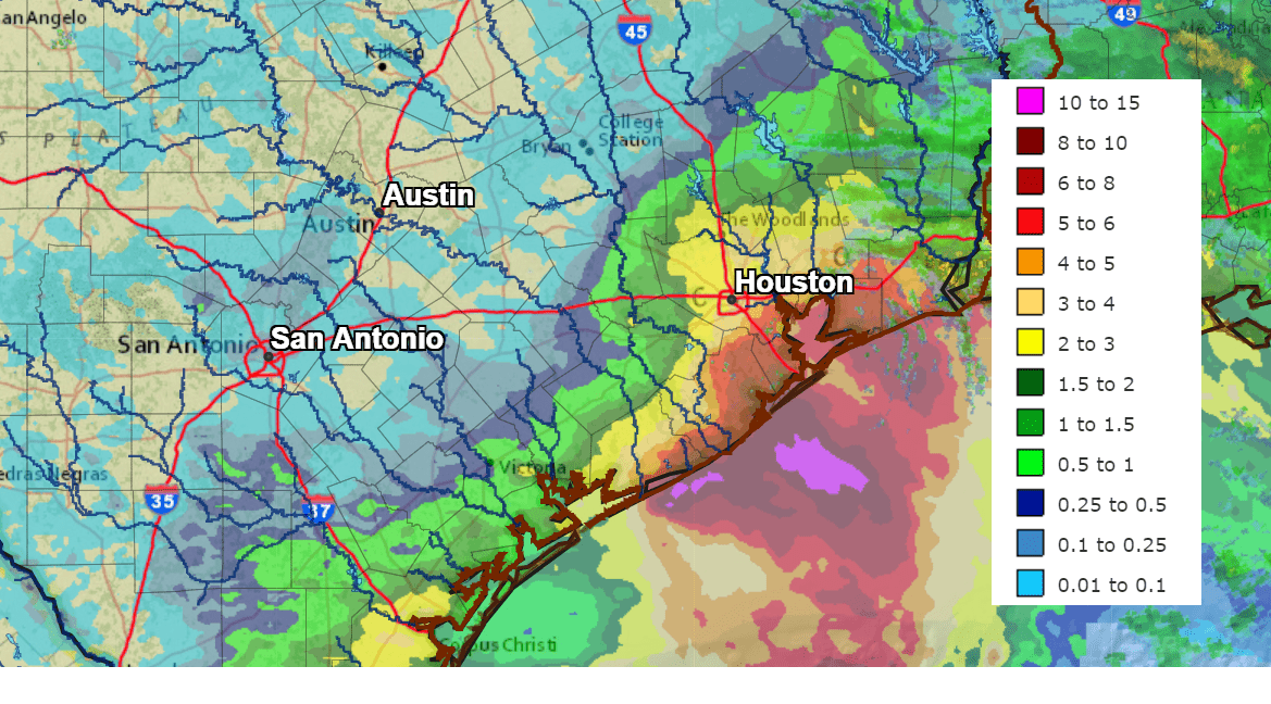
Nicholas did produce strong winds across the coastal plains. Reports include gusts of 77 mph at the Palacios Airport, 61 mph at Bay City, 46 mph at Wharton and 44 mph 12.4 miles southwest of Eagle Lake in Colorado County.
Nicholas tracked northeast into Southeast Tuesday morning and has steadily weakened. As of 1 pm, the center of Tropical Storm Nicholas was located about 30 miles southeast of Houston, close to Texas City. Nicholas was moving toward the east-northeast near 7 mph and this general motion should continue through tonight. An eastward turn is expected over Louisiana by Wednesday. The remnants of Nicholas are forecast to stall over western Louisiana late Wednesday into Thursday as steering winds fall off. Maximum sustained winds have decreased to near 40 mph with higher gusts. Additional weakening is forecast during the next couple of days, and the storm is forecast to become a tropical depression by Tuesday night.
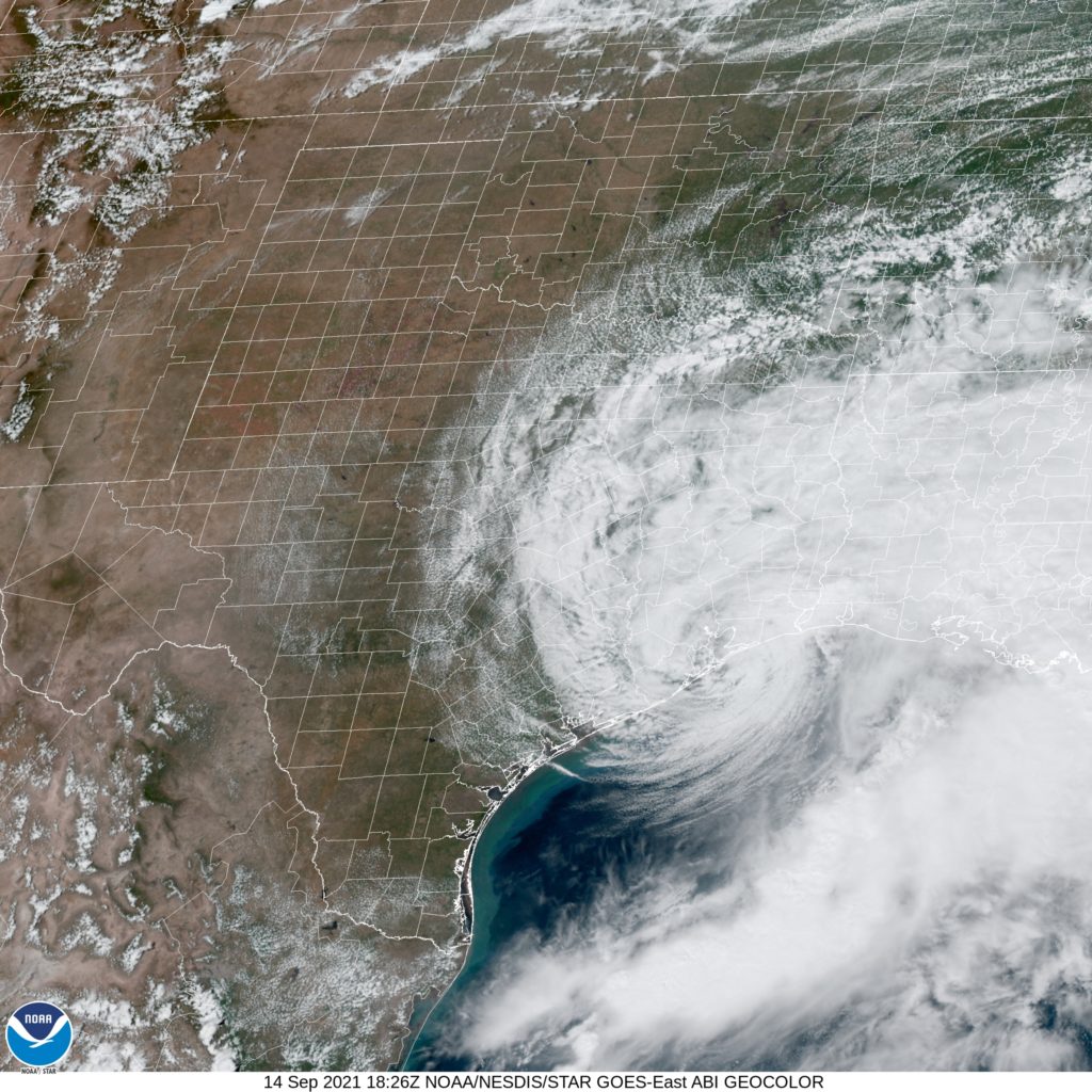
Weather radar at 2:00 pm showed the rain associated with Nicholas was located just east of Houston, and extended east to cover most of southern and central Louisiana. There was no rain indicated across the Hill Country, Central Texas or the middle Texas coast.
For the Austin/Central Texas and Hill Country regions, mostly sunny and dry weather can be expected this afternoon through Saturday as the remnants of Nicholas remain over Louisiana and eventually track further to the east. Across the coastal plains region, a few spotty rain showers will be possible each afternoon through Saturday, but rain amounts should be quite low. Unfortunately, we’re not done with warm weather just yet. High temperatures are forecast to be in the upper 80s this afternoon, be around 90 degrees Wednesday, in the low 90s Thursday, then warm to the mid-90s Friday and Saturday.
Next Sunday and Monday, there will be a slight chance for rain showers and thunderstorms across the region as an area of moisture spreads inland from the Gulf. High temperatures will remain warm in the low and mid-90s.
Forecast solutions are calling for a cold front to push south across the area the middle of next week. The front is expected to bring some showers and thunderstorms along with slightly cooler air for the second half of the week. High temperatures are forecast to fall to the upper 80s, with low temperatures in the 60s. Autumn officially begins September 22nd.
Bob
Social Media