The weather has been great this week! Although the days have been warm, the nights have been pleasantly cool and the relative humidity has been low. According to LCRA’s Hydromet, temperatures early Friday morning dipped into the 50s to low 60s at all locations. Similar conditions look to continue this weekend and all of next week.
Friday’s weather maps showed as broad, stable ridge of high pressure in the upper atmosphere located over Texas and the southern Plains states. The ridge is keeping our weather dry and very stable. Meanwhile at the surface, a Canadian air mass extends from the Great Lakes to South Texas. A weak cold front will push south through our region late Friday night that will reinforce the sunny and early fall-like pattern for Sunday and the first half of next week. Expect a light northeasterly wind today through Tuesday.
- High temperatures this afternoon through next Wednesday are forecast to be mostly in the upper 80s. A few spots along the Interstate 35, including Austin, could reach close to 90-92 degrees.
- Lows Saturday and Sunday mornings will generally be in the mid and upper 50s across the region.
- Lows Monday, Tuesday and Wednesday mornings will range from the mid-50s across the Hill Country, to the low 60s near the coast.
Forecasters are closely monitoring the progress of Tropical Storm Orlene located off the coast of Southern Mexico, roughly 270 miles southwest of Manzanillo. Orlene is currently packing top winds of 60 mph and moving toward the northwest at 5 mph. Orlene is forecast to strengthen into a hurricane Friday night or Saturday, then push inland along the west coast of Mexico sometime early Monday. Orlene is predicted to decay fairly rapidly over the mountains of northwestern Mexico Monday into Tuesday. Rain associated with the tropical system is forecast to extend across northern and north central Mexico early next week, but stay well to the south and west of Texas. However, high-level clouds associated with the decaying tropical cyclone may spread over parts of the Hill Country and Central Texas next Tuesday and Wednesday.
Another weak cold front is forecast to push south through the region next Thursday that will reinforce the sunny, dry and autumn-like weather pattern for late next week and next weekend. Expect highs around 90 degrees, with lows in the upper 50s to low 60s.
Looking out into the week of October 10th, some changes in the weather pattern look to take place around the 11th into the 12th when a trough of low pressure is forecast to track east across the southern Plains states, pulling Gulf moisture north into South and Central Texas. This will result in a chance for scattered rain showers and isolated thunderstorms. As of now, significant totals of rain are not expected. Dry and slightly cooler weather looks to follow Thursday and Friday. No significant change in the temperature is forecast throughout the week.
There are still no signs of that first “good” autumn cold front looking out through the middle of October.
Tropical Weather Update
All eyes are on Hurricane Ian. Surface observations indicate that the center of Hurricane Ian made landfall at 1:05 pm CDT near Georgetown, South Carolina with maximum sustained winds of 85 mph. Ian should weaken rapidly after landfall and transition into a post-tropical cyclone Friday night. Ian should dissipate over western North Carolina or Virginia late Saturday. Considerable flash and urban flooding, and minor river flooding is possible across coastal and northeast South Carolina, coastal North Carolina, and southeast Virginia today.
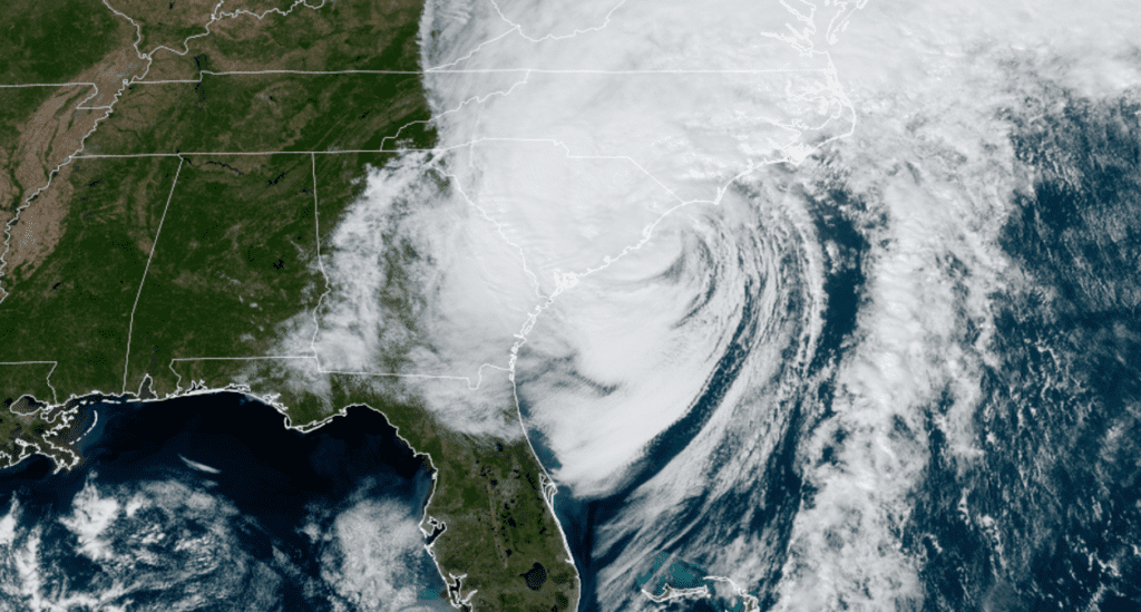
NOAA/Colorado State University/RAMMB 09/30/2022 1:10 pm CDT
Forecasters are also monitoring a tropical wave over the far eastern tropical Atlantic. This system is producing an area of disorganized showers and thunderstorms Environmental conditions are forecast to be conducive for gradual development of this system, and a tropical depression could form early next week as the system moves westward to west-northwestward over the eastern tropical Atlantic. NHC forecasters are giving this system a 60 percent chance for tropical development over the next 5 days.
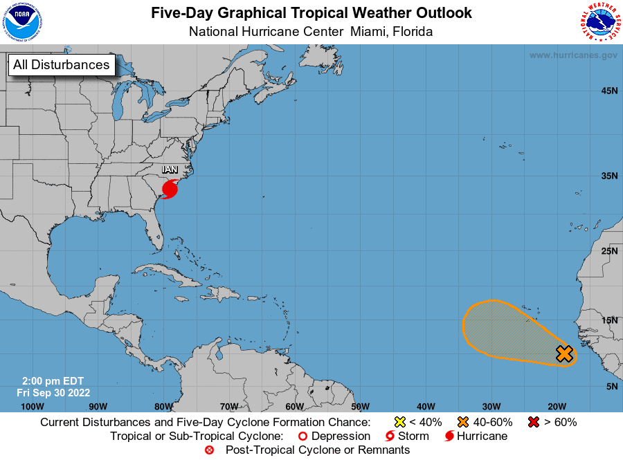
Elsewhere, conditions are quiet and tropical cyclone development is not expected over the next 5 days.
Spot the International Space Station
There will be opportunities to spot the International Space Station across Central Texas starting Sunday evening, continuing each evening next week. For times and locations to look for your specific location, visit NASA’s Spot the Station website: https://spotthestation.nasa.gov
Have a great weekend!
Bob
Social Media