Damp and cool conditions Thanksgiving Day and Friday gave way to a beautiful, sunny weekend. As we start off the new week, sunny and pleasant weather continues across Central and South Texas. Our region is currently under the influence of a very stable atmosphere in the wake of Friday night’s storm system. Sunny conditions will continue Monday afternoon. Temperatures are forecast to warm into the low and mid-70s. Expect a south breeze at 5-10 mph.
Southerly winds at the surface and in the lower atmosphere are forecast to increase this evening and overnight in advance of a trough of low pressure diving southeast out of the northern Rockies. Increasing moisture levels will cause the sky to become mostly cloudy to overcast by midnight. In addition, some patchy drizzle will be possible across Central Texas and parts of the Hill Country. Across the coastal plains, a few spotty light rain showers and drizzle are forecast after midnight. Interestingly, temperatures are expected to trend warmer overnight as a warm front lifts north from the coast. Temperatures will be in the 50s Monday evening, but are forecast to warm after midnight into the upper 50s across the Hill Country, into the low and mid-60s across Central Texas, and into the low 70s across the coastal plains.
Tuesday’s weather will start off cloudy with patchy drizzle. However, the sky is expected to become mostly sunny by afternoon as the moisture begins to move off to the east and northeast. Breezy and warm conditions are expected. High temperatures will range from the mid-70s across the Hill Country, to the low 80s across the coastal plains. Southwesterly breezes will increase to 10-15 mph, with occasional gusts to 25 mph.
Breezy and noticeably cooler conditions are forecast to develop Tuesday night when a Canadian cold front associated with the approaching trough sweeps southeast through the area. The front is forecast to move across the Hill Country around midnight and push off the middle Texas coast before sunrise Wednesday. It now appears conditions will stay dry across our region as atmospheric conditions remain unfavorable for the development of rain and storms. However, rain and storms are forecast to develop further to the east across East Texas and Louisiana.
Breezy and much cooler conditions are forecast to develop behind the cold front late Tuesday night, continuing through Wednesday afternoon. Expect a northwesterly wind at 15-20 mph, with gusts to 30 mph. Wind speeds should decrease late Wednesday afternoon. Lows Wednesday morning will range from the upper 30s across the Hill Country, to the low 40s across Central Texas, to the low 50s across the coastal plains. High temperatures Wednesday will generally be in the mid-50s.
Wednesday night looks to be the coldest night of the week. A light freeze will be possible across parts of the Hill Country and a few of the low-lying areas of Central Texas. Lows Thursday morning will include the low and mid-30s across the Hill Country, the mid and upper 30s across Central Texas, and the low 40s across the coastal plains.
Mostly sunny and cool conditions look to continue Thursday. Expect high temperatures in the low and mid-50s.
Milder temperatures will make a return Thursday night into Friday as southerly breezes return to the area. Expect a party to mostly cloudy sky across the region. Lows Friday morning will range from the mid-40s across the Hill Country, to the mid-50s towards the coast. High temperatures Friday are predicted to be in the upper 60s to low 70s.
For the upcoming weekend, forecasts call for a mostly cloudy to overcast sky Saturday and Sunday as Gulf moisture spreads inland off the Gulf ahead of a weak cold front sinking south across the Plains states. The front is forecast to stall across the Red River Valley Sunday. A couple of spotty light rain showers will be possible both days, but no significant rain is predicted. Temperatures will be mild, with highs forecast to be in the mid-70s, and lows in the upper 50s to low 60s.
Looking ahead to next week, the focus of attention will be on a fairly strong cold front that is predicted to arrive sometime early Tuesday. Much cooler temperatures are forecast behind the front Tuesday through Friday, with highs falling to the 50s to low 60s, and lows dropping into the 40s. Forecasts call for a chance for rain along the cold front, with additional chances for rain continuing Wednesday through Friday as a weak overrunning pattern develops.
Tropical Weather Outlook
Weather conditions remain very quiet across the tropical Atlantic as the 2022 hurricane season draws to a close. The season will officially come to an end Wednesday, November 30th.
A Surprisingly Wet Week Across Texas
A series of storm systems and cold fronts over the course of last brought several periods of rain. The rain culminated Friday night into Saturday morning when the main storm system moved across the state. Rain amounts over the past week have been significant, with totals of more than 5 inches recorded across parts of Wharton and Matagorda Counties. The northern Hill Country saw fairly widespread totals between 3 and 4 inches. Meanwhile, most of Central Texas saw totals of between 1 and 3 inches.
NWS Estimate of rain falling between Monday 11/21, and 9 am Monday, 11/28:
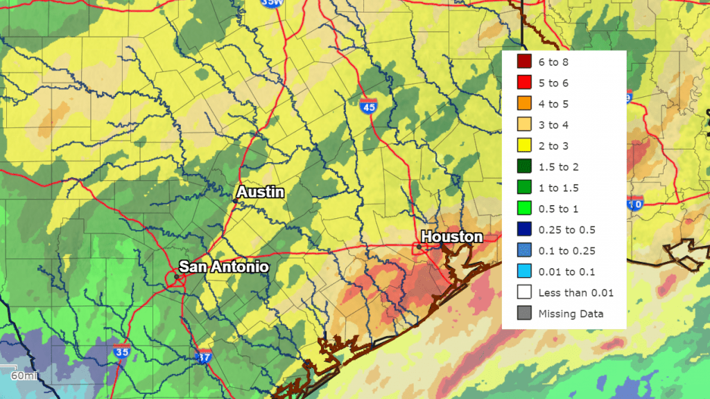
Courtesy: National Weather Service West Gulf River Forecast Center
Bob
Social Media