Could a La Niña be on the horizon? On Thursday, NOAA hoisted a La Niña Watch, meaning the forecast favors the development of La Niña conditions within the next six months. The point of a La Niña Watch is to give planners for energy, agriculture, disaster management, and other sectors a heads-up that the chance of La Niña developing is greater than the combined chance of neutral and El Niño.
During June 2020, sea surface temperatures (SST) were near average in the east-central equatorial Pacific and below average in the eastern Pacific.
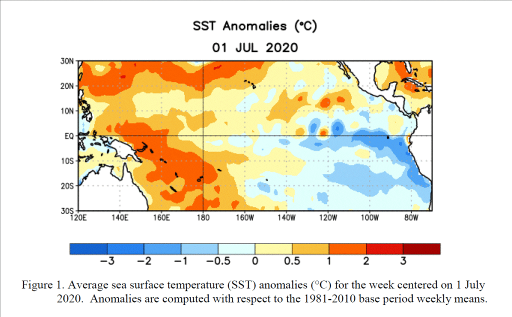
Below the surface, negative equatorial subsurface temperature anomalies (averaged across 180°-100°W) weakened from May through June. Also during the month, low-level wind anomalies were easterly across the east-central Pacific, while upper-level wind anomalies were westerly over parts of the far western and eastern Pacific. Tropical convection was suppressed over the western and central Pacific, and near average over Indonesia Overall, the combined oceanic and atmospheric system was consistent with ENSO-neutral.
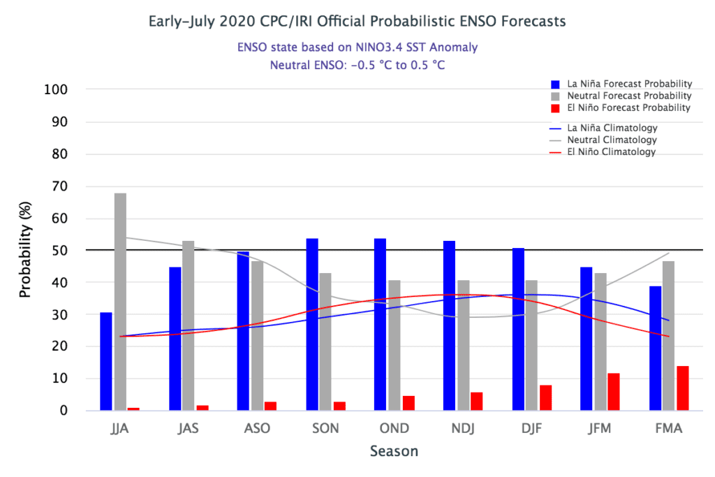
The suite of the latest oceanic/climate models are roughly split between the development of La Niña and continued ENSO-neutral (A Nino-3.4 index between -0.5°C and +0.5°C) during the fall and winter. Based largely on dynamical model guidance, the Climate Prediction Center forecaster consensus slightly favors La Niña development during the August-October season, and then lasting through the remainder of 2020.
CPC’s updated outlook calls for ENSO-neutral conditions to continue through the summer, with a 50-55% chance of La Niña development during Northern Hemisphere fall 2020 and continuing through winter 2020-21. Keep in mind, a 50-55% chance of La Niña is not a very strong probability. There is still about a 40-45% chance that neutral conditions will remain through the fall and winter, and a smaller but non-zero chance of El Niño—around 5-10%.
According to the Climate Predictions Center, one of the factors restraining the probability of La Niña in the current forecast is the lack of a substantial source of cooler-than-average water under the surface of the tropical Pacific. Subsurface temperatures are near average in the central Pacific, with some cooler-than-average water remaining in the east, as the upwelling Kelvin wave of the past couple months dissipates. The relatively conservative 50-55% chance of La Niña in part reflects this current absence of a large source of cooler water to supply the surface in the near future.
The development of a La Niña will potentially be a very important factor for Central Texas weather this fall and winter. Historically, the development of La Niña has promoted a drier and milder than normal weather pattern in the fall and winter months. Some La Niña’s have even caused the development of drought periods. Should a La Nina develop, we should expect our weather to trend drier than normal heading into fall.
Stay tuned for further updates as observations and forecasts begin to give us a better idea where the tropical Pacific will be headed this fall.
Bob
Social Media