Signals are pointing toward a mild and drier-than-normal winter for Texas. That is the latest assessment from NOAA’s Climate Prediction Center in Thursday’s annual winter weather outlook release. In the outlook, CPC forecasters indicated a moderate to strong La Niña would likely be the dominant winter weather feature influencing weather across the U.S. this year.
“With a La Niña well established and expected to persist through the upcoming 2020 winter season, we anticipate the typical, cooler, wetter North, and warmer, drier South, as the most likely outcome of winter weather that the U.S. will experience this year,” said Mike Halpert, deputy director of NOAA’s Climate Prediction Center.
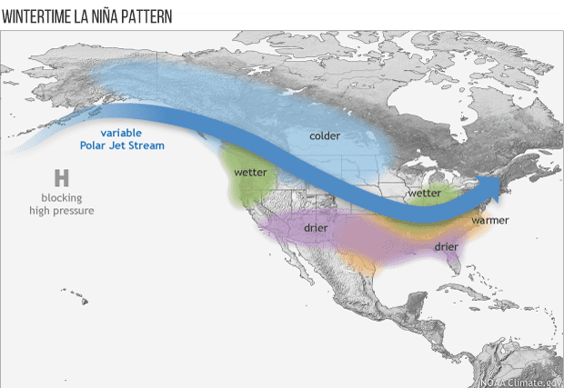
In winters featuring a moderate to strong La Nina, the Jet Stream flowing east from Asia is often displaced north up to the Pacific Northwest and western Canada instead of flowing east across the southern U.S. With most of the storm systems tracking north into Canada, the southern U.S., from California to Florida, misses out on the storms and often sees below average rainfall. At the same time, the coldest air tends to stay bottled up across Canada instead of flowing south with the jet stream.
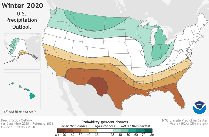
Precipitation
According to NOAA’s outlook, wetter-than-average conditions will be most likely across the northern tier of the U.S., extending from the Pacific Northwest, across the Northern Plains, Great Lakes and into the Ohio Valley, as well as Hawaii and northern Alaska. The greatest chances for drier-than-average conditions are predicted in the Southwest, across Texas, along the Gulf Coast and in Florida. In fact, Far West Texas and southern New Mexico have the highest probability for below normal rain than another other location in the U.S. More modest chances for drier conditions are forecast in southern Alaska, and from California across the Rockies, Central Plains and into the Southeast. The remainder of the U.S., including the Mid-Atlantic and Northeast, falls into the category of equal chances for below-, near-, or above-average precipitation.
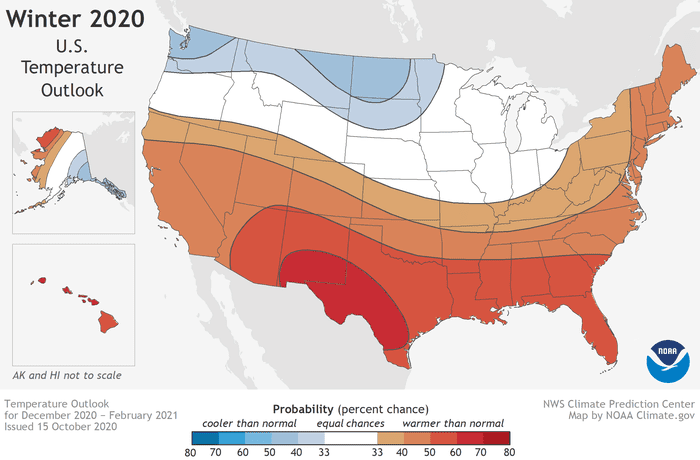
Temperature
NOAA’s outlook calls for the greatest chances for warmer-than-normal conditions to extend across the Southern tier of the U.S. from the Southwest, across the Gulf States and into the Southeast. More modest probabilities for warmer temperatures are forecast in the southern parts of the West Coast, and from the Mid-Atlantic into the Northeast. Above-average temperatures are also favored for Hawaii and western and northern Alaska.
Below-normal temperatures are favored in southern Alaska and from the northern Pacific Northwest into the Northern Plains, with equal chances for below-, near- or above-average temperatures in the remaining regions.
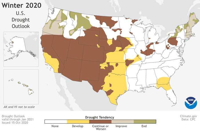
Drought
The ongoing La Nina is expected to expand and intensify drought across the southern and central Plains, eastern Gulf Coast, and in California during the months ahead. NOAA’s 3-month drought outlook, looking out through the end of January, calls for drought development across most of Texas during the next three months due to the drier than-normal and warmer than-normal weather pattern.
Keep in mind NOAA’s winter outlook is a look at general weather conditions expected between December and the end of February. Individual storm systems may bring periods of rain and colder temperatures from time to time, but conditions overall should average drier-and milder-than normal.
Stay tuned for more updates on the upcoming winter as we go through late October and November.
Bob
Social Media