It is shaping up to be a very wet week for all of Central and South Texas. Widespread moderate to heavy rain is forecast Tuesday through Wednesday, with additional periods of moderate rain expected late week and through the upcoming weekend. Widespread totals of 4-6 inches are forecast across the region through Friday. However locations along and near the Interstate 35 corridor could see totals of 8 inches or greater. In addition to the heavy rain threat, there will also be a threat for strong to severe storms across parts of the Hill Country and Central Texas this afternoon through midweek.
This week’s wet pattern is expected to develop as a large trough of low pressure located over southern Nevada tracks very slowly to the east. Forecasts call for several smaller waves of low pressure to move around the large trough and spread across Texas throughout the week, causing rounds of rain and storms. Considerable moisture is spreading into Texas out of the Gulf, setting the stage for the development of moderate to heavy rain.
As of midday, a cluster of strong thunderstorms with heavy was moving east across Llano, Burnet and Lampasas Counties. These storms have had a history of producing totals of 1-2 inches in a fairly short period of time. This activity is forecast to exit to the east by mid-afternoon.
This afternoon, the sky looks to stay mostly cloudy across the region. There will be a 30-40 percent chance for scattered rain showers and isolated thunderstorms, but most totals should remain under a half inch. Attention will turn to the Rio Grande Plains and West Texas late this afternoon and early evening where scattered strong to severe thunderstorms are forecast to develop. High-resolution forecasts call for these thunderstorms to spread east across the Hill Country through the evening hours, possibly reaching the Austin/Central Texas region close to midnight. Some of these storms may be severe, producing large to very large hail and damaging winds. The Storm Prediction Center has placed the western and northern Hill Country, under an Enhanced Risk (a 3 out of 5 risk) for severe storms this afternoon through tonight. This Enhanced risk area is generally along and west of a line stretching from Forth Worth to San Saba, to Rocksprings. SPC forecasters have placed the eastern Hill Country and the I-35 corridor, from Waco to Austin to San Antonio under a Slight Risk (a 2 out of 5 risk) for severe storms. Areas east of I-35 have been placed under a Marginal Risk (a 1 out of 5 risk). These storms will also be capable of producing moderate to heavy rain. Additional showers and thunderstorms are forecast to develop out west late this evening and spread east overnight. The storms this evening and overnight will be capable of producing totals of 1-3 inches across parts of the Hill Country and Central Texas. For the middle-Texas coast, expect a 30 percent chance for showers and thunderstorms overnight.
Tuesday through Wednesday, multiple rounds of rain showers and thunderstorms are forecast to develop and spread east across the region as the upper low approaches western Texas. Moderate to occasionally heavy rain is expected. Forecasts call for widespread totals in the range of 2-4 inches Tuesday and again on Wednesday. With the ground wet, this volume of rain will increase the threat for flooding and flash flooding. Some of the thunderstorms on Tuesday may be severe, producing large hail and damaging winds. SPC forecasters have placed the area between Brady, Austin and Dallas under a Slight Risk for severe thunderstorms. The rest of the region has been placed under a Marginal Risk.
Forecasts call for additional periods of rain showers and thunderstorms Thursday and Friday and also through the weekend as the upper trough slowly drifts east into Texas and stalls. Totals are not expected to be quite as heavy during this period, with daily amounts generally in the range of 0.5 to 1 inch. The threat for severe storms is also expected to decrease late week and into the weekend. The probability for rain Thursday through Sunday will still be near 50-60 percent.
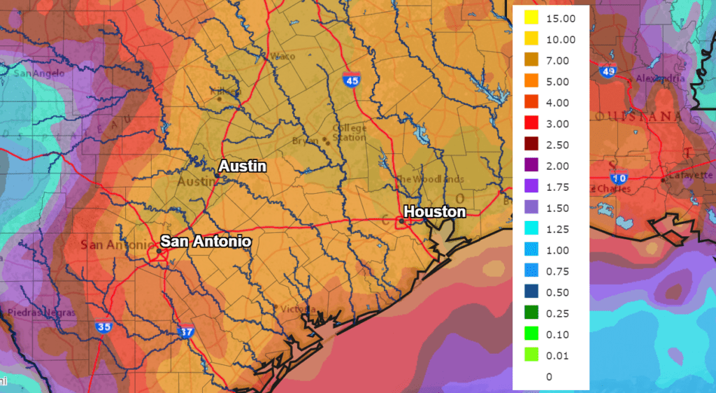
National Weather Service rainfall forecasts for the period from this afternoon through late Friday call for widespread totals of 4 to 6 inches across the entire region. These same forecasts call for 5-day totals of 6 to 8 inches for areas near and along I-35, including the Austin metro area. Some isolated totals greater than 8 inches will be possible.
NWS Rainfall Forecast for the Period 7 am Monday through 7 am Saturday:
The outlook for next week calls for more scattered showers and thunderstorms as our region remains in a very moist flow off the Gulf of Mexico.
This is a very wet forecast and the threat for flash flooding will be increasing throughout the week. Stay weather aware and remember to Turn Around, Don’t Drown.
Bob
Social Media