The weather over the past week has featured warm days, pleasant nights, and no rain. Similar conditions are forecast to continue this weekend and through the first half of next week as the storm track remains well up to our north and east.
On this Friday, we’re seeing widespread middle and high-level clouds covering Central and South Texas. These clouds are being generated by a weak trough of low pressure that is lifting northeast out of northern Mexico.
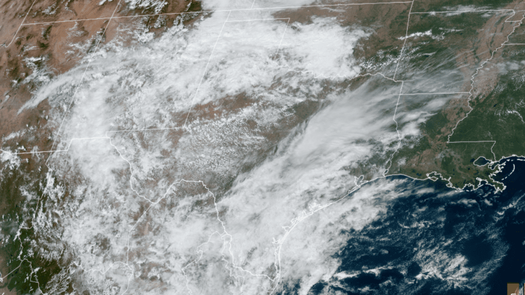
NOAA/CIRA/RAMMB 10/07/2022 1:30 pm
These clouds will cause a mostly cloudy to partly cloudy sky across the region this afternoon and evening. No rain is forecast as moisture levels in the lower atmosphere remain quite low. Despite the clouds, today’s temperature is still forecast to warm to around 88-91 degrees. Expect a light northeasterly wind at 5-8 mph. Lows Saturday morning will range from the low 60s across the Hill Country, the upper 60s across the coastal plains.
Friday’s weather maps showed a weak Canadian cold front situated across the Red River Valley that is pushing to the south. The front is forecast to spread south across the Hill Country and Central Texas regions after midnight Friday night, pushing off the middle Texas coast after sunrise on Saturday. Drier and just slightly cooler air will arrive behind the cold front. Friday’s clouds are predicted to shift to the east late Friday night, opening the door for mostly sunny conditions Saturday and Sunday. High temperatures both days are predicted to be near 88-90 degrees. Lows Sunday and Monday mornings will range from around 60 degrees across the Hill Country, to the mid-60s towards the coast. Expect an east to southeasterly breeze at 5-10 mph on both days.
Similar weather conditions are forecast Monday through Wednesday as Texas remains under a weak ridge of high pressure. Expect mostly sunny days with high temperatures near 88-90 degrees and morning lows in the low and mid-60s.
Some changes in the weather pattern are forecast to take place late next week when a large trough of low pressure moves east out of the northern Rockies. The trough will help push a somewhat stronger Canadian cold front south across Texas next Thursday. As of now, just a few showers and isolated thunderstorms are forecast along and just behind the cold front Thursday into Thursday evening. The probability for rain will only be around 20-30 percent and rain amounts should average less than a quarter inch.
There is some potential for the rain to be a bit heavier late next week. Some of today’s forecast solutions call for a portion of the remnant moisture from tropical storm Julia to get pulled north into South Texas late next week. Should this be the case, it could result in more widespread and heavier rains along the cold front. We’ll need to wait a few days to see how this situation will evolve.
Partly cloudy and somewhat cooler weather looks to follow the cold front next Friday and next weekend. Expect high temperatures to be in the low and mid-80s, with low temperatures in the upper 50s to low 60s. Longer-range forecasts call for even cooler temperatures for the week of October 17th, with highs dropping close to 80 degrees, and lows in the 50s.
Tropical Weather Outlook
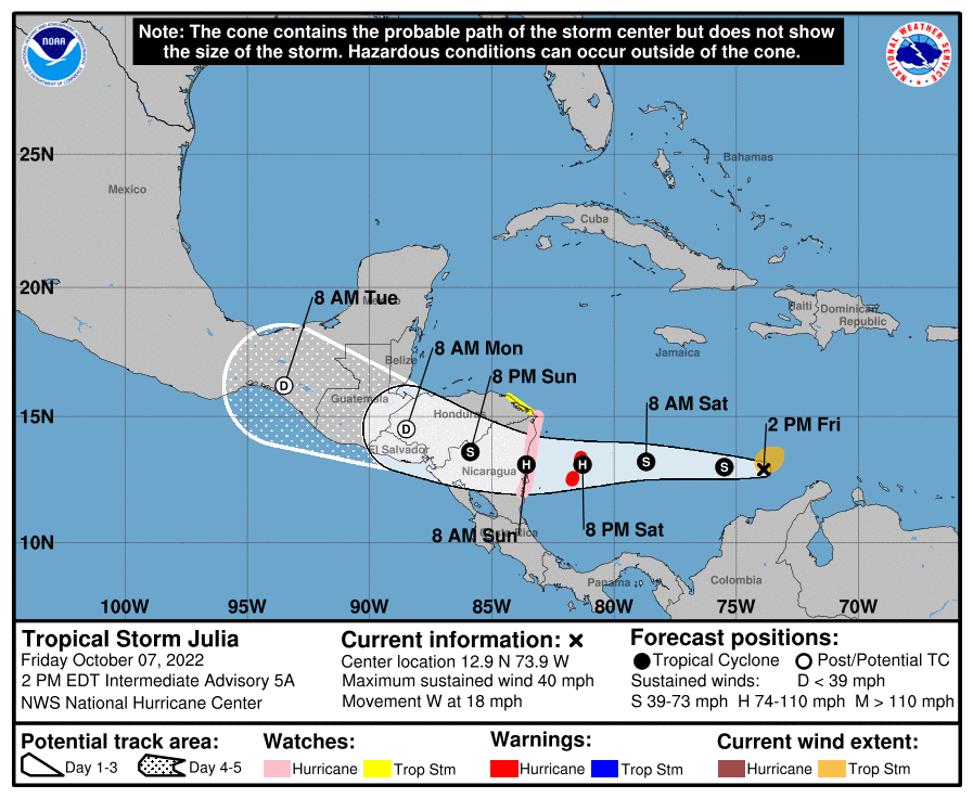
The tropical depression over the southern Caribbean Sea strengthened Friday morning and has now become Tropical Strom Julia. As of 1 pm CDT, the center of tropical storm Julia was located about 150 miles north-northeast of Barranquilla, Columbia. Julia was moving toward the west near 18 mph. A westward motion with some decrease in forward speed is expected through Sunday. On the forecast track, the center of Julia is expected to move across the southwestern Caribbean Sea during the next couple of days, passing near San Andres and Providencia Islands Saturday evening, reaching the coast of Nicaragua Sunday morning. After landfall, Julia or its remnants are expected to turn west-northwestward and move across Central America through Monday. Maximum sustained winds were near 40 mph with higher gusts. Strengthening is forecast, and Julia is expected to become a hurricane by Saturday evening before it reaches San Andres and Providencia Islands, and the coast of Nicaragua.
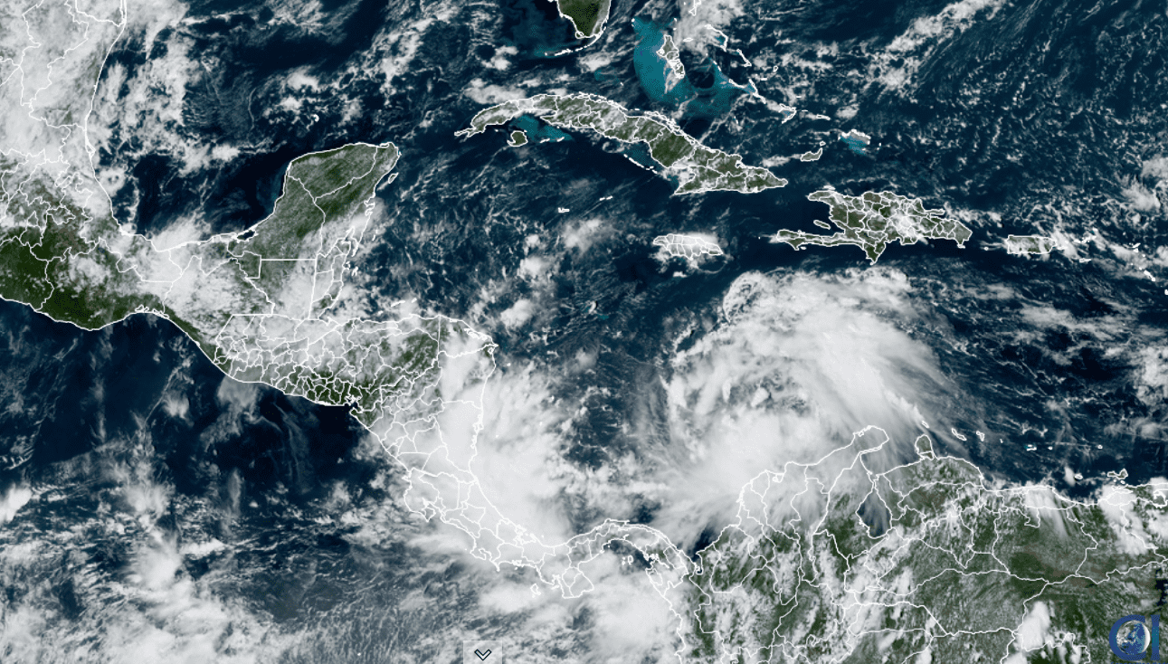
NOAA/CIRA/RAMMB 10/07/2022 1:30 pm CDT
Elsewhere across the tropical Atlantic, conditions are quiet. There are no systems in place which pose a threat for tropical development over the next 5 days.
The October Full Moon this Weekend
The October full moon, often referred to as the “Hunter’s Moon,” will take place this Sunday at 3:55 pm CDT. This means we will be treated to a nearly full moon on both Saturday and Sunday nights. The moon will rise shortly after sunset on both nights. When checking out the moon, look for very bright Jupiter almost two fists to its upper right of the moon. The two objects will move higher in the sky as evening proceeds.
Have a good weekend!
Bob
Social Media