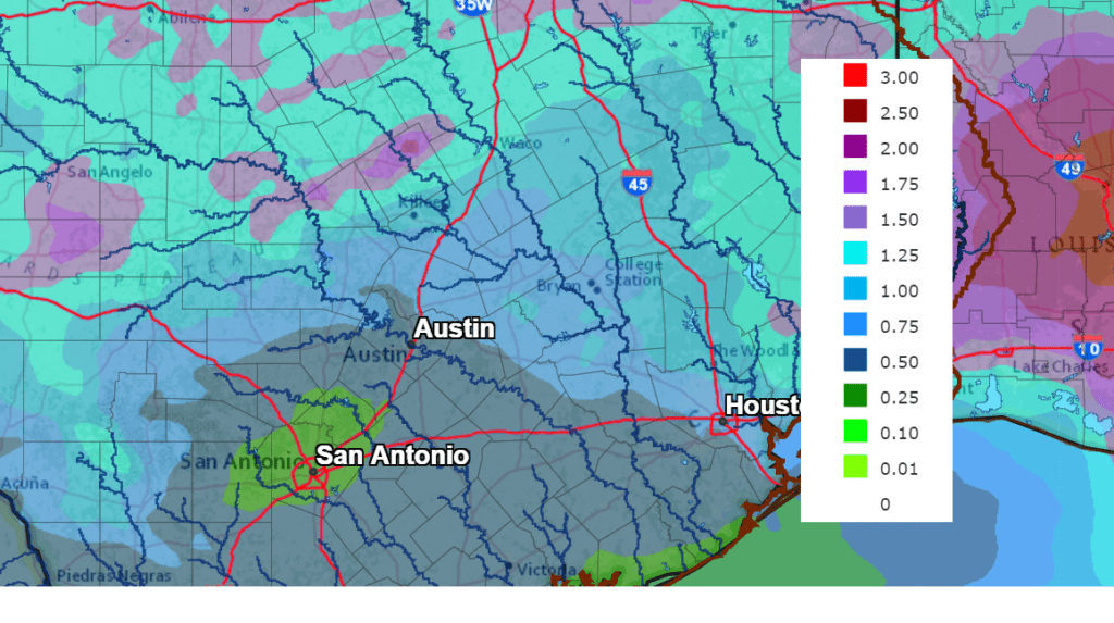
After a taste of summer-like temperatures over the past few days, cooler readings are expected this week, continuing through next week. This slightly cooler weather pattern will be in addition to a more unsettled pattern that looks to bring a chance for rain to our region each day this week. Forecasts indicate much of the area could see totals of around an inch or possibly more over the next seven days.
Monday’s weather maps showed a cold front pushing into Texas out of the southern Plains and the southern Rockies. As of late morning, the front stretched from just north of Dallas, to near Midland, then northwest to around Gallop, New Mexico. The front is predicted to sink southeast and move across the Hill Country tonight, reaching the Austin area just after sunrise Tuesday. The cold front is expected to slowly push south to the coast, pulling up stationary just off the coast on Wednesday. Slightly cooler air will filter in behind the cold front. Weak atmospheric disturbances are forecast to track across the region out of the Southwestern U.S. this week, causing widespread overrunning clouds along with periods of rain and scattered thunderstorms. The most favorable period for rain and thunderstorms is predicted to occur Friday into Saturday.
This afternoon’s weather is forecast to be partly cloudy, breezy and warm. No rain is expected as the atmosphere will be a bit too stable. High temperatures will generally be in the mid and upper 80s. Expect a southeasterly breeze at 10-15 mph.
Tonight, scattered thunderstorms are forecast to develop ahead of and along the cold front over parts of West Texas. Forecasts call for the thunderstorms to track east over parts of the Hill Country late evening and overnight. Some of these thunderstorms may become severe and produce large hail and damaging winds. The Storm Prediction Center has placed the area west of a line stretching from Fort Hood, to Burnet to Bandera under a Slight Risk (a 2 out of 5 risk) for severe thunderstorms overnight. The Austin metro area and the Instate 35 corridor has been placed under a Marginal Risk (a 1 out of 5 risk) for severe thunderstorms after midnight. The probability for rain overnight will be near 50 percent across the Hill Country, 40 percent along the Interstate 35 corridor and near 20 percent at most other locations. Totals through sunrise Tuesday are forecast to average between a quarter and a half inch across the Hill Country and the Interstate 35 corridor, and much lower elsewhere. Lows Tuesday morning are predicted to be in the upper 50s to low 60s across the Hill Country and the I-35 regions and be around 68-70 degrees at most other locations.
Tuesday, there will be a slight chance for scattered rain showers and thunderstorms across the entire region throughout the day as the cold front slowly sinks south to the coastal plains. Expect a mostly cloudy sky and somewhat cooler readings. High temperatures will range from the upper 60s to low 70s across the Hill Country, to the mid-70s across Central Texas to the low and mid-80s near the coast.
Tuesday night, forecasts call for a somewhat increased chance for scattered rain showers and thunderstorms to develop across the region as a weak wave of low pressure pushes east out of West Texas. Severe storms are not anticipated. The probability for rain will be near 30-40 percent. Totals through sunrise Wednesday are forecast to be around a quarter inch, or less. Lows Wednesday morning will include the mid and upper 50s across the Hill Country, the low 60s across Central Texas and be near 70 degrees across the coastal plains.
Wednesday through Thursday, expect a mostly cloudy sky along with periods of scattered rain showers and isolated thunderstorms as additional waves of low pressure move over the region. The probability for rain will be near 30 percent. Totals both days are predicted to average less than a quarter inch. High temperatures are forecast to be in the low and mid-70s. Lows Thursday and Friday mornings will range from the mid-50s across the Hill Country to near 60 degrees across Central Texas to the mid-60s near the coast.
Friday into Friday evening, the chance for rain and thunderstorms is forecast to increase as a wave of low pressure tracks east out of West Texas. The probability for rain will be near 50 percent. Totals are forecast to generally average between a quarter and a half inch. High temperatures Friday will be in the low and mid-70s.
The outlook for the upcoming weekend calls for continued mostly cloudy weather along with slight chance for occasional rain showers and isolated thunderstorms. A fairly strong cold front is forecast to push south across the region early Saturday morning, with the front moving into the Gulf by Saturday afternoon. More waves of low pressure approaching from the west will cause a weak overrunning pattern of clouds and rain. Weekend totals are forecast to generally average between a quarter to a third of an inch. Temperatures will be noticeably cooler, with high temperatures in the upper 60s. Lows Sunday and Monday mornings will include the mid-40s across the Hill Country, near 50 degrees across Central Texas and low/mid 50s near the coast.
The outlook for next week calls for partly cloudy and mild weather Monday through Thursday. High temperatures will be in the upper 70s to low 80s, with lows mostly in the 50s. Some of the forecast guidance points toward an increasing chance for rain late next week into the following weekend.
NWS Rainfall Forecast for the Period 7 am Monday through 7 am Next Monday:
Have a good week and enjoy the cooler temperatures.
Bob
Social Media