Heavy rains moved across the northern portion of the watershed Tuesday evening and Tuesday night, producing rain totals of 2-6.5 inches across parts of Callahan, Brown and Mills Counties. A pocket of 2-4 inch totals also occurred across southeastern San Saba, southwestern Lampasas and northwestern Burnet Counties.
Late this morning, Doppler radar showed numerous showers and thunderstorms moving from southwest to northeast across parts of the Hill Country and much of Central Texas. Additional scattered showers and thunderstorms are forecast to develop and continue through the afternoon, from the Hill Country to the middle Texas coast. High-resolution forecasts call for the activity to persist through late afternoon and evening, with most of the showers diminishing around sunset. The probability for rain will be near 60-70 percent for the Hill Country and Central Texas regions and near 30 percent for the coastal plains.
Some of today’s thunderstorms may be strong to severe and capable of procuring damaging winds and large hail. The Storm Prediction Center has placed the Hill Country and Central Texas regions under a Margin Risk (1 out of 5 risk) for severe thunderstorms through 7 am Thursday.
Some of this morning’s forecasts call for the redevelopment of thunderstorms across the northern Hill Country late this evening, with the activity spreading to the east-southeast overnight.
Rain amounts this afternoon through Thursday morning are forecast to generally average around 1 inch across the Hill Country and Central Texas regions, but isolated totals of 2-4 inches will be possible.
Thursday through Saturday, additional periods of rain and thunderstorms are predicted as our region remains in a break between ridges of high pressure located to our west and our east. The probability for rain will be near 60-70 percent Thursday and Friday, decreasing to 40 percent on Saturday. Some of this rain may at times be moderate to heavy.
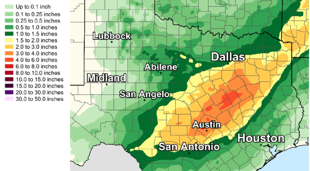
Total rain amounts this afternoon through Saturday morning are forecast to generally average between 2 and 3 inches across the Hill Country and Central Texas regions. Isolated higher totals will certainly be possible.
NWS Rainfall Forecast for the Period 7 am Wednesday through 7 am Saturday.
Just a slight chance for rain is forecast Sunday and Labor Day.
Temperatures should be less hot over the next few days, with high temperatures mainly in the low and middle 90s.
Bob
Social Media