After several days of sunny weather, a cloudy and damp pattern has now set up across Central and South Texas. This pattern is forecast to persist into early next week as a series of low pressure troughs from the Pacific spread east and move across Texas. In this new pattern, temperatures are forecast to be mild as the coldest air remains bottled up over Canada and the northern states.
Tuesday’s weather maps showed a large trough of low pressure in the upper atmosphere parked just off the coast of southern California. Circulation around the upper trough is helping to pull clouds and moisture from the Gulf of Mexico north into Texas. Meanwhile, a Canadian cold front is slowly pushing south across Central Texas. As of noon, the front stretched from north of Lufkin, to Austin to near Del Rio. The front is forecast to slowly push south across Central Texas this afternoon, reaching the coastal plains region this evening and overnight. For areas along and behind the cold front, occasional light rain showers are forecast this afternoon and tonight as a weak overrunning pattern develops. The probability for rain through Tuesday morning at any given location will be near 50 percent. Rain amounts through Tuesday morning are forecast to average near or less than a quarter inch. Tuesday afternoon’s temperature will depend on the location of the cold front. For locations behind the front, afternoon temperatures will fall into the mid-50s. For locations out ahead of the front, expect high temperatures in the low and mid-70s. Lows Tuesday morning will be in the low and mid-40s across Central Texas , but in the mid-50s across the coastal region.
Wednesday’s weather will feature a cloudy sky and cool temperatures. Occasional light rain showers are forecast throughout the day as the weak overrunning pattern persists. The overrunning pattern should diminish Wednesday night as the warm front moves back to the north. Wednesday will be the coolest day of the week with high temperatures in the mid-50s across the Hill Country and Central Texas regions and in the mid to upper 60s near the coast. Lows Thursday morning will range from the mid-40s across the Hill Country to the mid-60s near the coast.
Mostly cloudy and noticeably warmer weather is forecast Thursday. There will be a slight chance for a few showers throughout the day, but rain amounts, if any should be quite low. High temperatures will be in the low and mid-70s.
The chance for scattered rain showers and thunderstorms will increase Thursday night and continue into Friday morning as the trough low pressure that had been stalled off the California coast tracks across North Texas. Rain amounts are predicted to generally average between a quarter and a half inch. Lows Friday morning will be in the mid and upper 50s, with mid-60s expected towards the coast.
Friday afternoon into Friday night, the chance for rain looks to diminish as a Pacific cold front brings in mild and drier air. Friday afternoon temperatures are forecast to reach the mid-70s. Lows Saturday morning will be in the low and mid-50s.
Heading into the weekend, expect a partly cloudy sky and just a very slight chance for rain showers on Saturday. High temperatures will be in the mid-60s.
The chance for rain showers and scattered thunderstorms is forecast to increase Sunday afternoon and continue Sunday night into Monday afternoon as a large Pacific trough of low pressure tracks northeast across Texas. Some of the storms could possibly be strong to severe. Rain amounts through the period are forecast to average around a half inch, with isolated heavier totals. The chance for rain should end Monday evening when drier air spreads in behind a cold front. High temperatures Sunday and Monday will be in the mid-70s.
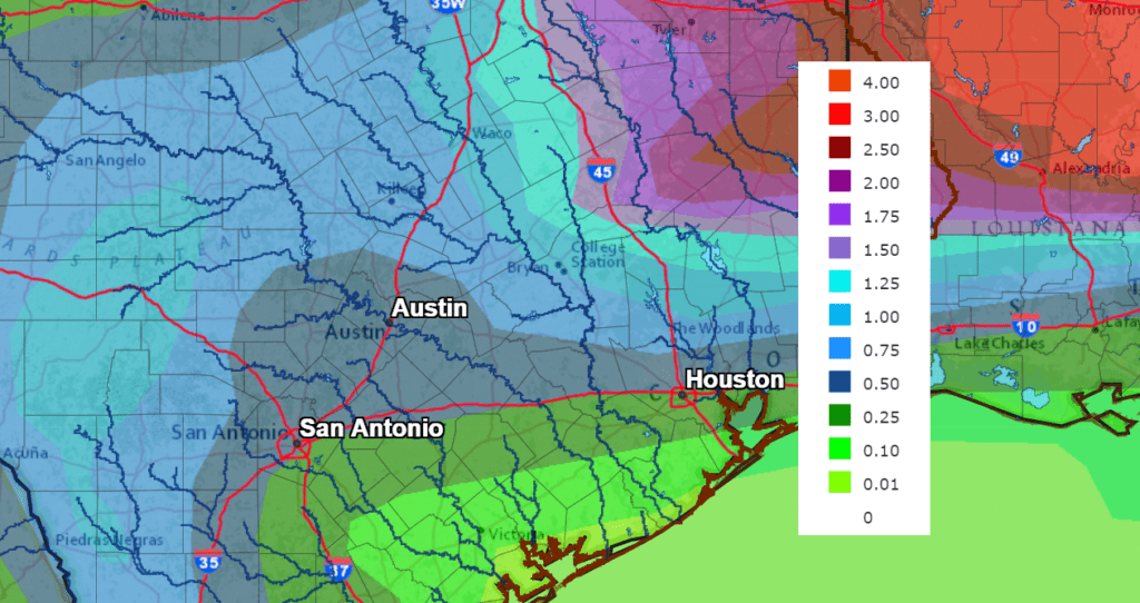
Total rain amounts over the next week are forecast to generally average around an inch across the Hill Country and Central Texas regions and be near a half inch across the coastal plains region.
NWS Rainfall Forecast for the Period 6 pm Tuesday through 6 pm Next Tuesday:
The outlook for next week calls for sunny and dry weather Tuesday and Wednesday with high temperatures in the 60s. A chance for rain is forecast next Thursday when a cold front moves across the area.
Have a good week.
Bob
Social Media