Widespread rain showers and thunderstorms developed across the region overnight as an unusually strong area of low pressure over northern Mexico created a very efficient overrunning pattern across Texas. Some of the highest totals of rain occurred along the middle Texas coast and Southeast Texas where Wednesday’s cold front pulled up stationary. As of midday Thursday, LCRA’s Hydromet showed general totals of 1-1.5 inches of rain have fallen across the Hill Country, totals of 1-3 inches across Central Texas and totals of 2-4 inches along the middle Texas coast. An area of 5-6 inch totals stretched across much of Wharton County.
At midday, weather radar showed the moderate to heavy rain that had been over the Hill Country and Central Texas regions this morning has pushed up to the north. An area of light precipitation covered a good part of the Hill Country and West Texas. Meanwhile, moderate to rains were still occurring along the middle Texas coast between La Grange and Matagorda in the vicinity of the stalled cold front.
High-resolution forecasts call for the area of low pressure currently over located over northeastern Mexico to lift north-northeast and move over West Texas and the Edwards Plateau this afternoon and evening. The low will cause occasional light to moderate precipitation to spread over the Hill Country and most of Central Texas this afternoon and evening. However, the precipitation is expected to diminish by late evening across Austin and Central Texas, and diminish across the Hill Country around midnight. The rain and thunderstorms are forecast to exit the middle Texas coast by mid-afternoon. Rainfall forecasts call for additional rain amounts of a quarter to a half inch through late evening.
Observations at 1 pm showed light snow falling across a good part of the Concho Valley, extending east to the western Edwards Plateau, between Sonora and Eldorado. Light freezing rain was being observed around Brady. Further east, all of the precipitation was being reported as rain.
The National Weather Service has posted a Winter Storm Warning for the Concho Valley, the Big Country and the western Hill Country including San Saba, Mason, Kerr, Edwards and Real Counties through 6 am Friday. Across this area, a mixture of light rain and sleet is forecast this afternoon, with the precipitation becoming mostly all snow by this evening. The precipitation should end around midnight. Snow totals of 3-6 inches are forecast for the area between San Saba and Junction.
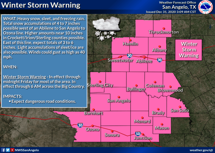
A Winter Weather Advisory has been posted for Gillespie, Llano and Burnet Counties were the light rain will become mixed with sleet, freezing rain and snow this afternoon and evening. Snow totals are forecast to be near 1 inch.
A few snow flurries may become mixed with the light rain over parts of Travis, Williamson and Hays Counties this evening, but no accumulation is expected.
There will be a light freeze across the Hill Country and parts of Central Texas Thursday night into Friday morning. Lows New Year’s Day will be near 30-32 degrees across the Hill Country, near 31-35 degrees across Central Texas and be in the upper 30s across the coastal plains.
Mostly sunny, dry and cool weather is forecast New Year’s Day, continuing through the weekend. Another freeze is expected across the Hill Country and Central Texas regions Saturday morning. High temperatures will be in the 50s Friday and Saturday, warming into the 60s on Sunday.
The next chance for rain is forecast to develop the middle of next week when another trough of low pressure tracks east across Texas. As of now, rain amounts are forecast to average between 0.25 and 0.5 inches.
I hope everyone has a Happy and Safe New Years! For folks in the Hill Country, enjoy the snow!
Bob
Social Media