Some of the hottest temperatures so far this summer are expected to develop over the weekend and early next week as the current heat wave intensifies across Texas. Potentially dangerous levels of heat, beyond what is normal for early July, are forecast.
Friday’s weather maps showed a broad subtropical ridge of high pressure, or heat dome, covering the entire southern U.S. and northern Mexico. The ridge was centered over southern Oklahoma and northeastern Texas. Observations showed the ridge has strengthened since Thursday, and it’s predicted to remain unusually strong through the weekend and Monday. Forecasts call for the center of the ridge to shift west to the Desert Southwest and the southern Rockies by Tuesday, then hang out over that general area for the remainder of next week.
With the center of the ridge spreading west across North Texas this weekend, high temperatures are forecast to trend hotter, with the hottest readings taking place on Sunday.
- High temperatures Friday afternoon are forecast to be near 101-103 degrees across the Hill Country and Central Texas regions, and near 98-101 degrees across the coastal plains.
- High temperatures Saturday are forecast to be 101-105 degrees across the Hill Country and Central Texas regions, and near 101-103 degrees across the coastal plains.
- High temperatures Sunday are forecast to be near 102- 107 degrees across the Hill Country and Central Texas regions, and near 101-104 degrees across the coastal plains.
- High temperatures Monday are forecast to be near 101-105 degrees across the Hill Country and Central Texas regions, and near 99-102 degrees across the coastal plains.
Do note that nighttime temperatures are also predicted to be unusually warm over the weekend. Lows Saturday through Monday mornings are forecast to be in the upper 70s across the Hill Country, and be around 80-82 degrees across most of Central Texas and the coastal plains.
The National Weather Service has posted a Heat Advisory for the northern Hill Country along with the area along and east of the Interstate 35 corridor, including Colorado and Wharton Counties, through 8 pm Friday evening. An additional Heat Advisory is planned for the weekend that will cover the entire region.
Generally speaking, sunny and dry weather is forecast this afternoon through Monday. However, there will be a very slight chance for the development a few scattered rain showers and thunderstorms across the northern Hill Country and the northern counties of Central Texas late Saturday afternoon and Saturday evening when a weak cold front sags south and stalls across North Texas. Showers and storms developing along the boundary could possibly track south to the northern counties of our region late Saturday. The probability for rain will only be 20 percent and rain amounts, if any, will total well below a quarter inch. Some of the thunderstorms may produce strong and gusty winds. But again, most areas will likely stay dry.
Looking ahead to next Tuesday through Friday, sunny, hot ,and generally rain-free conditions look to continue. Forecasts call for the center of the high pressure ridge to persist across the western and southwestern U.S. all of next week and next weekend. Much of Texas is predicted to be on the eastern periphery of the ridge, and as a result, readings are forecast to moderate down roughly 2-5 degrees. Some scattered afternoon showers and isolated thunderstorms will be possible Wednesday through Friday as the ridge weakens and a moist flow strengthens off the Gulf of Mexico. However, the probability for rain will only be 20 percent and rain amounts, if any, will be quite low.
- High temperatures Tuesday are forecast to be near 100-102 degrees across the Hill Country and Central Texas regions, and near 98-100 degrees across the coastal plains.
- High temperatures Wednesday are forecast to be around 100-101 degrees across the Hill Country and Central Texas regions, and in the upper 90s across the coastal plains
- High temperatures Thursday and Friday are forecast to be close to 100 degrees across the Hill Country and Central Texas regions, and in the mid-90s across the coastal plains.
Long-range forecasts for next weekend and the week of July 18th call for little overall change. The center of the upper ridge is forecast to remain over the southern Rockies, while the broad ridge will strengthen slightly across Texas. A few isolated rain showers look to continue, but no widespread or significant rain is expected. High temperatures are forecast to hold close to 100 degrees throughout the period.
Tropical Weather Outlook
Weather conditions are currently quiet across the tropical Atlantic. There are no systems in place which pose a threat for tropical development over the next five days.
Catch the Constellation Scorpius this Month
Scorpius is among the most distinctive of constellations in the zodiac. With a little imagination, you can see its stars tracing the shape of a Scorpion. The brilliant red star Antares lies at the Scorpion’s Heart. The constellation has the shape of the letter J, with the curved bottom of the J representing the Scorpion’s curved Tail. There’s even a Stinger, consisting of two stars – Shaula and Lesath – noticeable for their nearness to each other. For evening viewing, July and August are prime-time months for observing this wondrous constellation. And note, the Sagittarius Teapot follows in the sky not far behind Scorpius.
In early July, Scorpius climbs to its highest point in the sky at about 11 p.m. local time. Because the stars return to the same place in the sky about one-half hour earlier with each passing week, look for the celestial Scorpion to be at its highest in mid-July around 10 pm, and around 9 pm by late July.
Look for Scorpius low in the south-southeastern sky.
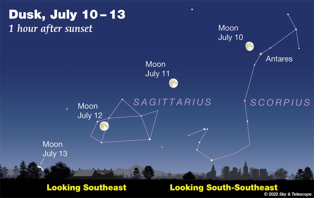
Image Courtesy Sky and Telescope
Have a good weekend. Stay hydrated and stay cool!
Bob
Social Media