Quiet weather conditions remain in place across Central Texas as our region remains under the influence of a broad ridge of high pressure in the upper atmosphere. This ridge is keeping the storm track well up the north near the U.S./Canadian border. The ridge is forecast to remain over our area through Monday before it begins moving off to the east. With that in mind, few changes in the weather are expect today through Monday. Widespread clouds and patchy fog area are forecast for areas along and east of the Escarpment (Interstate 35) each morning. This will be followed by mostly sunny conditions midday through late afternoon. High temperatures this afternoon through Monday afternoon are forecast to be in the upper 70s to low 80s. A few spots may see the middle 80s Sunday and Monday. Low temperatures will be in the 50s Saturday and Sunday mornings and in the low to mid-60s Monday and Tuesday mornings.
Some changes in our weather are forecast to take place next week when a series of low pressure troughs push inland across the western U.S. While the troughs won’t make it to Texas, they will help push a couple of weak cold fronts across the state. The first cold front is predicted to move from western Texas to the coastal plains region during the day on Tuesday. With limited moisture in place, just a slight chance for spotty light rain showers is forecast along the front from the Interstate 35 corridor, southeast to the coast. The chance for rain will diminish from west to east Tuesday afternoon. Rain amounts, if any, should only average around a tenth of an inch. Dry and just slightly cooler weather will follow the cold front Tuesday afternoon. High temperatures Tuesday will be near 80 degrees. Lows Wednesday morning will range from the mid and upper 40s across the Hill Country to the low and mid-50s across Central Texas to the mid-60s near the coast. Veterans Day weather will be sunny with high temperatures mostly in the mid and upper 70s.
Forecasts call for another weak cold front to move across the area late next Thursday into early Friday morning. There will once again be a slight chance for a few rain showers along the front, but rain amounts, if any, should be quite low. Sunny, dry and slightly cooler weather will follow the cold front Friday into next weekend. High temperatures look to be in the upper 70s while lows will be in the 50s.
The outlook for the week of November 16the calls for no significant changes in the weather pattern across our region. A progressive west-to east wind flow across the country will bring more weak cold fronts, reinforcing the mild temperature pattern. High temperatures are forecast to be in the mid and upper 70s while lows will be mostly in the 50s. No significant rain is expected through the week.
Tropical Weather Outlook
After pushing inland over Honduras Wednesday into Thursday, the remnant center of Hurricane Eta has moved back over the western Caribbean Sea and is now a tropical depression. As of 3 pm CST Friday, the center of Tropical Storm Eta was located about 115 miles east of Belize City. The depression is moving toward the northeast near 7 mph. A northeastward motion at a faster forward speed is expected trough early Sunday. On the forecast track, the center of Eta will move across the northwestern Caribbean Sea tonight, approach the Cayman Islands Saturday, and be near central or western Cuba Saturday night and Sunday.
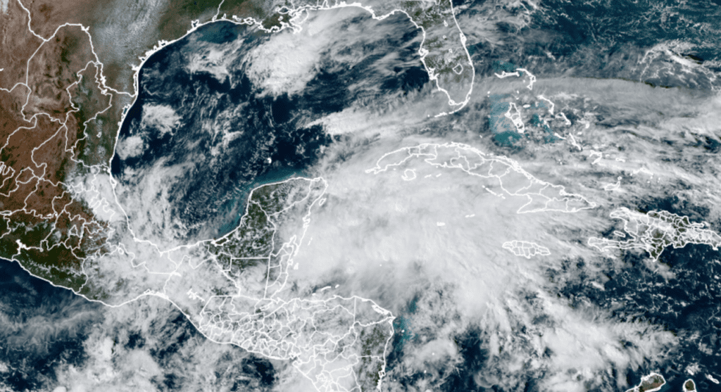
RAMMB-CIRA/Colorado State University 11/06/2020 2:00 pm CST
Reports from an Air Force Reserve Hurricane Hunter aircraft indicate that maximum sustained winds are near 35 mph with higher gusts. Eta is forecast to become a tropical storm again this tonight, with further strengthening likely through early Sunday.
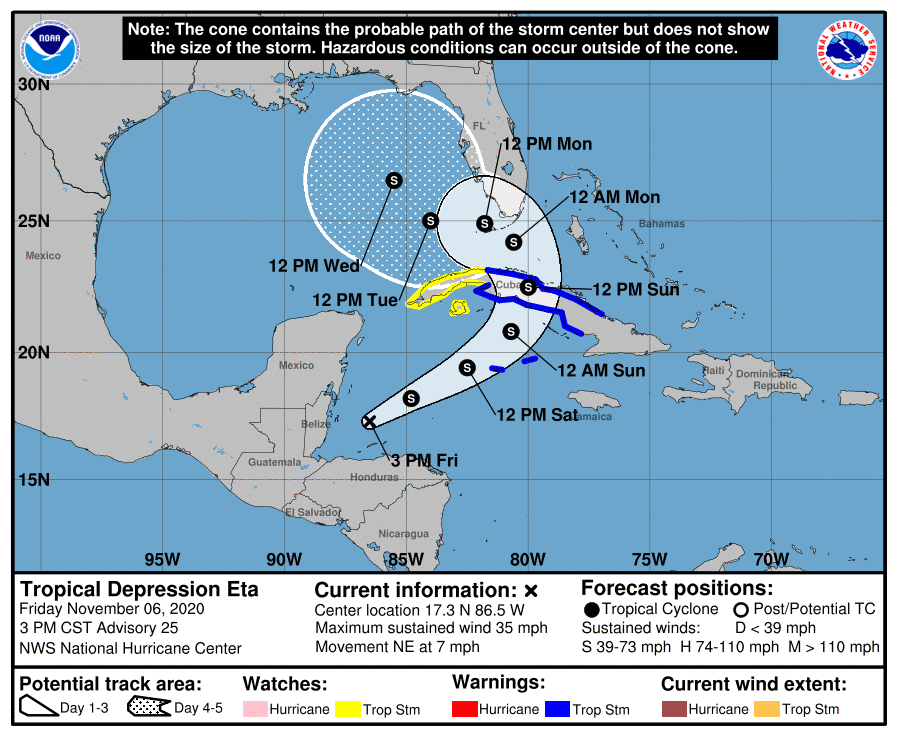
After moving across Cuba this weekend, National Hurricane Center forecasters call for Eta to bend to the northwest and move over the Florida Keys and possibly southern Florida on Monday. Eta is forecast to reach the eastern Gulf of Mexico on Tuesday. Eta is predicted to push inland somewhere over the central or eastern Gulf coast middle to late next week.
Eta does not pose a threat to the Texas coast as next Tuesday’s cold front should keep the system well to our east.
Jupiter and Saturn in the Evening Sky
Over the past few weeks, have you been watching Jupiter and Saturn draw toward each other in the evening sky? If not, catch the view this weekend. Spot them in the south-southwestern sky during and after dusk. Jupiter is the bright one; Saturn is now only about 4½° to its upper left. They were much further apart over the summer months. Watch them continue to creep toward each other for the rest of the fall. They’ll pass just 0.1° apart at conjunction on December 21st, low in twilight, as fall turns to winter.
Have a good weekend.
Bob
Social Media