Very mild temperatures will be in place today through Thursday before much cooler air arrives Friday that will likely persist through the weekend.
Warm, moist air is spreading north from the Gulf of Mexico, resulting in very humid conditions across the region. This very moist air, combined with a weak passing disturbance, caused the development of scattered rain showers and even a couple of isolated thunderstorms across the region Monday morning into Monday afternoon. Additional spotty showers look to continue across the northern counties of Central Texas and the Hill Country through late afternoon. Elsewhere, partly cloudy and warm conditions are forecast. Monday’s temperature is forecast to peak in the low and mid-80s.
The sky will be partly to mostly cloudy Monday night. Lows Tuesday morning will generally be in the mid and upper 60s.
Tuesday through Thursday, we’ll see a pattern of nighttime and early morning clouds, followed by a most sunny to partly cloudy sky in the afternoon. Humid conditions will continue. Daily high temperatures are forecast to be in the low and mid-80s, with lows in the low and mid-60s.
A big change in the weather will take place Friday morning into Friday afternoon when a strong cold front pushes southeast through our area. This front will be driven south by a large trough of low pressure moving east out of the Rockies. The front is predicted to reach the northern Hill Country just before sunrise Friday, the Interstate 35 corridor sometime mid to late Friday morning, and the coastal plains region Friday afternoon. The chance for rain along the cold front appears low due to weak convergence and limited moisture. But the trough and front will be tapping into some chilly air located across western Canada. Expect much cooler temperatures Friday and through the weekend.
- High temperatures Friday will include the mid and upper 60s across the Hill Country and Central Texas regions, and the mid-70s across the coastal plains.
- Lows Saturday morning are forecast to be in the low 40s across the Hill Country, the mid-40s across Central Texas, and around 50 degrees across the coastal region.
Saturday’s weather is shaping up to be mostly cloudy and cool. Some patchy light rain or sprinkles will possible Saturday morning into early Saturday afternoon as a weak disturbance passes over the region. Rain amounts are predicted to total under a tenth of an inch. Expect a partly cloudy sky Saturday night through Sunday.
- High temperatures Saturday are forecast to be in the mid and upper 50s.
- Lows Sunday will include the mid and upper 30s across the Hill Country, the low 40s across Central Texas, and the mid-40s towards the coast.
- High temperatures Sunday are forecast to be around 58-60 degrees.
- Lows Monday morning will include the low 40s across the Hill Country and Central Texas regions, with mid-40s across the coastal zone.
The outlook for next week calls for a partly cloudy sky and slightly warmer conditions next Monday through Wednesday. Expect high temperatures in low to mid-60s, with lows in the upper 40s to low 50s.
The next change in the weather will occur on Thursday when another strong cold front blows through the area. There will be a slight chance for rain along the front, followed by cooler temperatures late next week into the following weekend.
Tropical Weather Update
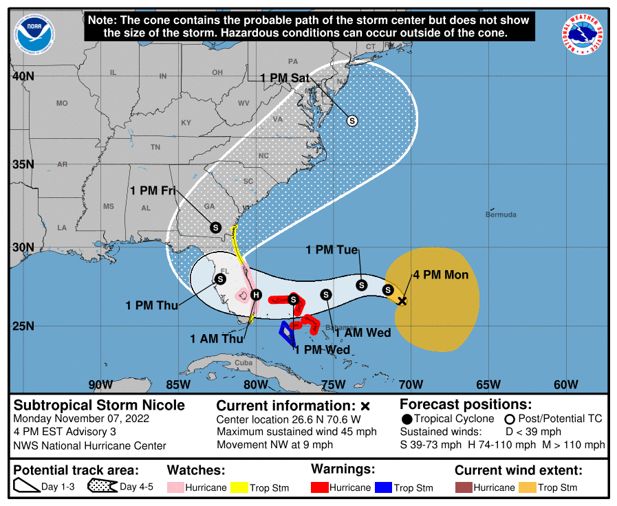
A strong disturbance located over the southwestern Atlantic has strengthened into Subtropical Storm Nicole.
As of 4 pm CST, the center of Subtropical Storm Nicole was roughly 435 miles east-northeast of the northwestern Bahamas. The storm was moving toward the northwest near 9 mph. A slower northwestward motion is expected tonight. A turn toward the west or west-southwest is forecast to begin by Tuesday night and that motion should continue through early Thursday. On the forecast track, the center of Nicole will approach the northwestern Bahamas on Tuesday and Tuesday night, move near or over those islands on Wednesday, and approach the east coast of Florida Wednesday night.
Maximum sustained winds were near 45 mph with higher gusts. Some slight strengthening is forecast tonight or Tuesday, with a faster rate of strengthening expected Tuesday night and Wednesday. Nicole is forecast to be at or near hurricane intensity by Wednesday or Wednesday night while it is moving near or over the northwestern Bahamas.
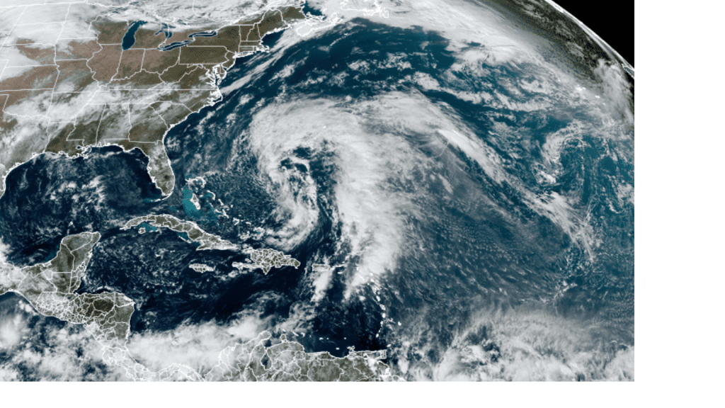
NOAA/University of Colorado/RAMMB 11/07/22 11:30 am CST
Total Eclipse of the Moon Monday Night
Earth’s shadow is about to engulf the Moon. Early Tuesday morning, there’s going to be a total lunar eclipse visible across much of North America and the entire Pacific Ocean.
Partial eclipse begins at 3:09 am CST Tuesday morning. Total eclipse will begin at 4:16 am CST; mid-eclipse is at 4:59 am CST; total eclipse ends 5:42 AM CST; partial eclipse ends 6:49 am CST. The first and last penumbral shading on the Moon may be detectable for 30 or 40 minutes before and after the partial stages — if the Moon is up at your location and the sky is not too bright. Watch for the moon to turn a blood-red color.
Bob
Social Media