A very active period of weather is forecast across the region this afternoon through Thursday evening. This afternoon a Canadian cold front is pushing southeast across the region. As of midday, the front was moving through Central Texas along a line from about College Station to Bastrop to new Braunfels. Behind the front, temperatures were mostly in the 40s. The front is forecast to slowly track southeast, arriving in La Grange area by late afternoon. The front is forecast to pull up stationary across the middle Texas coast this evening and overnight.
In advance of the cold front, scattered showers and thunderstorms are predicted to develop in a very moist and somewhat unstable atmosphere. In fact, some of the thunderstorms will have the potential to become strong or severe. The Storm Prediction Center has placed the I-35 corridor between Georgetown, Austin, San Antonio and areas to the southeast under a Marginal Risk (a 1 out of 5 risk) for severe thunderstorms through Wednesday evening. Do note the severe weather threat will continue overnight for the middle Texas coast. The main severe weather threats will be large hail and damaging thunderstorm winds.
This afternoon, scattered to numerous rain showers and thunderstorms are forecast to spread north from the coast into Central Texas and the Hill Country. Some of these showers will have the potential to produce totals to near 1-1.5 inches. Across the Hill Country region, scattered light rain showers and a couple of isolated thunderstorms are expected. This afternoon’s temperature will hold in the 40s across the Hill Country. Across Central Texas, readings will fall from the 70s into the 50s and 40s behind the front. Across the coastal region, readings will reach the upper 70s.
Beginning this evening, continuing overnight and Thursday, a fairly widespread coverage of light to moderate rain showers and isolated thunderstorms is forecast to develop and persist across the Hill Country, Central Texas and coastal regions as a powerful trough of low pressure begins to track northeast out of northern Mexico. The trough will cause a very efficient pattern of overrunning clouds and precipitation. The precipitation is forecast to taper off from west to east Thursday evening as the upper trough exits to the northeast.
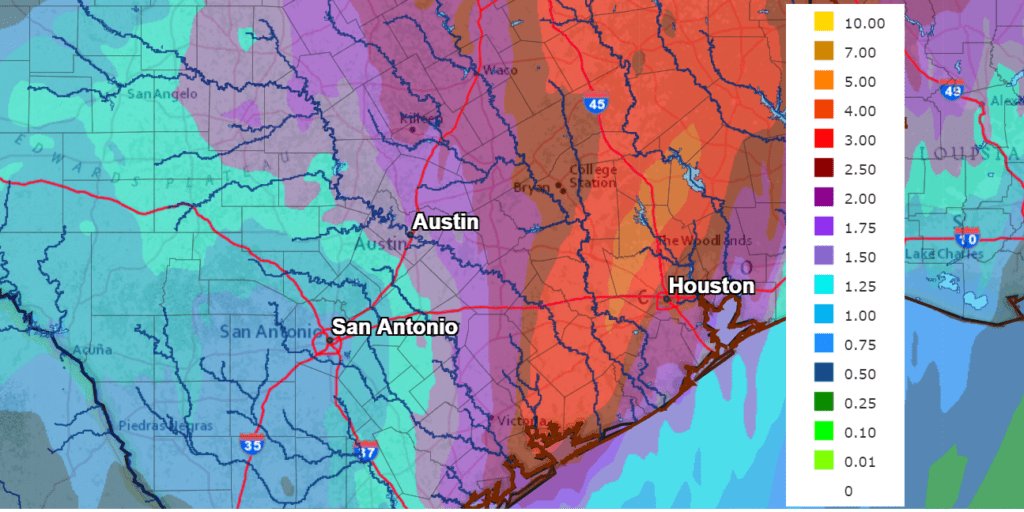
Rain amounts from Wednesday afternoon through Friday morning are forecast to be lowest across the western Hill Country and the highest along the middle Texas coast. National Weather Service forecasts call for totals of 1-1.5 inches across the western Hill Country and totals of 1-3 inches for the eastern Hill Country and Central Texas regions. Across the coastal plains, totals are forecast to average between 2 and 4 inches, with isolated totals of 4-6 inches possible. The National Weather Service has posted a Flash Flood Watch for Southeast Texas, including Colorado, Wharton and Matagorda Counties from 6 pm Wednesday through Thursday evening.
NWS Rainfall Forecast for the Period 6 pm Wednesday through 6 pm Friday:
Winter Weather Potential
Beginning late tonight, temperatures in the middle and lower atmosphere across much of the Hill Country are forecast to fall to, or just below freezing. This will allow the light rain to become mixed with sleet and snow flurries. On Thursday, the majority of the precipitation is forecast to become mostly all-snow, with the precipitation tapering off Thursday evening.
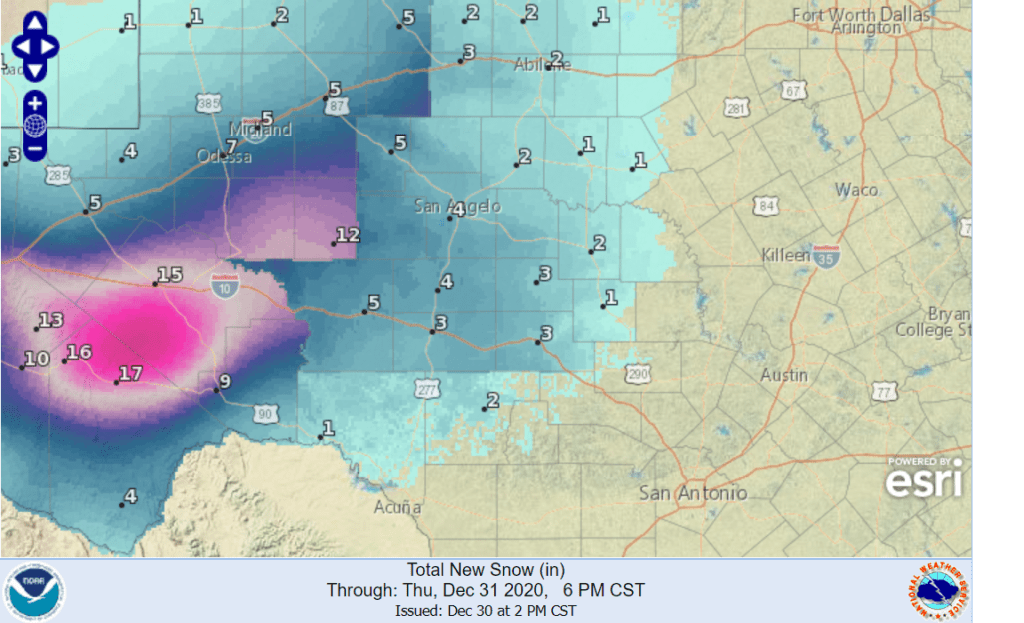
The Concho Valley and the western Hill Country will have the highest potential to see accumulating snow, where totals of 3-5 inches will be possible. Across the central and eastern Hill Country counties, totals of 1-3 inches are forecast are generally forecast. Further to the west, significantly higher snow totals are forecast along the Interstate 10 corridor, to the west of Ozona.
The National Weather Service has posted a Winter Storm Watch for Burnet, Llano and Gillespie Counties and counties to the west for Thursday afternoon and evening.
NWS Snowfall Forecast through Friday Morning:
For the Austin area and the Interstate 35 corridor, a few snowflakes will be possible late Thursday afternoon and evening, but no accumulations are forecast and no travel problems are anticipated as temperatures will be too warm.
Sunny and dry weather will be in place New Year’s Day and through the weekend.
Bob
Social Media