Ingredients are coming together that look to produce another round of rain showers and thunderstorms across our region Thursday night into Friday. Similar to the storm system Monday night, some of the storms may be strong to severe. A large tough of low pressure in the middle atmosphere that is currently located over New Mexico is forecast to track east-southeast to the Texas Panhandle tonight, then move across North Texas on Friday. Strong atmospheric lift provided from the trough and its associated cold front is expected to cause the development of widespread showers and thunderstorms.
Thursday afternoon satellite images showed a large area of low clouds covering the southern third of Texas that are quickly spreading to the north. These clouds are forecast to spread north to cover the central part of the state by late afternoon. As moisture levels increase this evening, scattered light rain showers and even a few isolated thunderstorms are predicted to develop through the evening hours and toward midnight. There will be an increased chance for shower and thunderstorm development after midnight when atmospheric lift increases and a Pacific cold front begins to push east out of West Texas. High-resolution forecasts call for widespread rain and thunderstorms to develop over the area between Coleman and Rocksprings shortly after midnight, with the rain and storms spreading east across the Hill Country between 2 am and 6 am. The widespread area of showers and storms is forecast to spread east across the I-35 corridor and Central Texas region in the hours just before sunrise, continuing through late Friday morning. The area of rain and storms should spread over the coastal plains region in the period between late Friday morning and late Friday afternoon.
While the heaviest rains will shift from west to east Friday morning into Friday afternoon, occasional light rain and isolated thunderstorms are predicted to continue across the region through late Friday afternoon as the upper low tracks across North Texas. The light rain is forecast to taper off Friday evening as the upper low exits to the northeast.
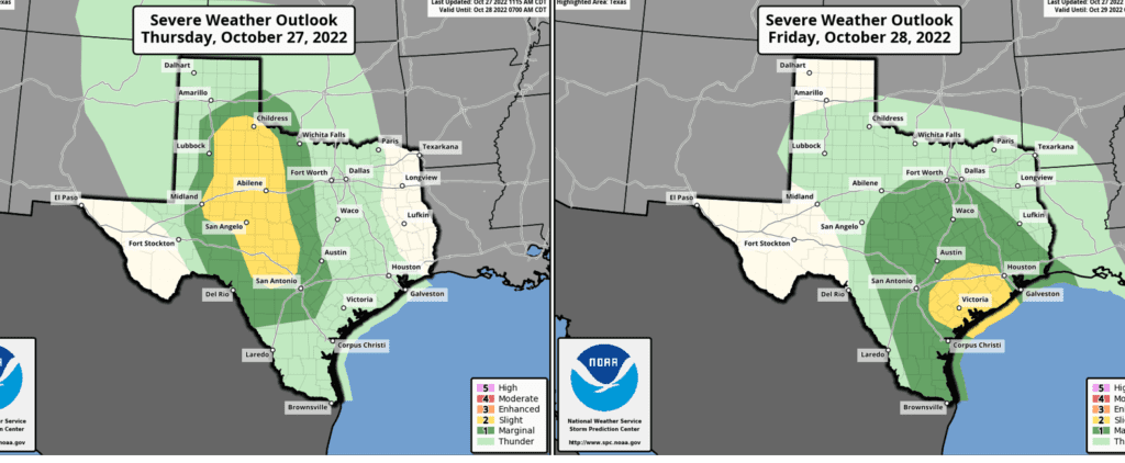
Similar to Monday, some of the thunderstorms late Thursday night through early Friday afternoon may be strong to severe. The primary severe weather threats will be large hail and damaging winds. But do note, there will also be a threat for isolated tornadoes across Southeast Texas on Friday.
- For the period through 7 am Friday, the Storm Prediction Center has placed most of the Hill Country under a Slight Risk (a 2 out of 5 risk) for severe thunderstorms through 7 am Friday. The area between Austin and San Antonio has been placed under a Marginal Risk (a 1 out of 5 risk) for severe thunderstorms.
- For the period from 7 am Friday through Friday evening, the Storm Prediction Center has placed the area between La Grange and Matagorda under a Slight Risk for severe thunderstorms. They have placed the rest of the region under a Marginal Risk for severe storms.
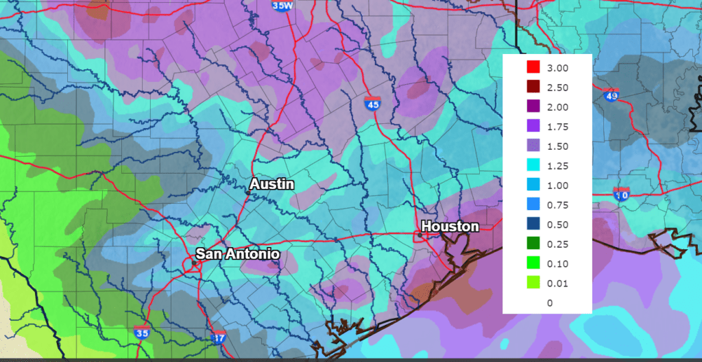
Rain totals through Friday evening are forecast to generally average around a half inch across the western and central Hill Country. Elsewhere, most amounts are forecast to average between 1 and 1.5 inches.
NWS Rainfall forecast for the period 7 pm Thursday and 7 pm Saturday:
Sunny and very fall-like weather is forecast this weekend. High temperatures both days are predicted to be between 70 and 75 degrees, with low temperatures close to 50 degrees. Similar conditions are forecast for next Monday through Wednesday.
The outlook for Halloween night calls for a clear sky with temperatures slowly falling through the 60s.
Bob
Social Media