After a three day break, rain and thunderstorms have returned to the weather forecast just in time for the Memorial Day weekend. This change in the forecast is coming about as a series of small waves of low pressure are beginning move into Texas out of the southern Rockies. Each of these low pressure waves will likely cause the development of showers and thunderstorms, followed by some periods of dry weather in between.
The first of the low pressure waves pushed into Northwestern Texas Thursday evening. It along with a weak cold front caused the development of showers and storms over parts of North, Northeast and Southeast Texas overnight, continuing into Friday. As of midday, radar showed strong to severe thunderstorms occurring across North Central Texas from north of Abilene, to east of Brownwood, to Waco, with the storms tracking to the east. Scattered rain showers and thunderstorms are occurring across the middle Texas coast into parts of Central Texas in a moist and slightly unstable atmosphere. Additional scattered, rain showers and scattered thunderstorms can be expected across the region this afternoon. Some storms across the northern Hill Country and the northern counties of Central Texas could be severe. The probability for rain will be near 50 percent. Today’s sky is forecast to remain mostly cloudy and this should keep high temperatures mostly in the mid and upper 80s.
The Storm Prediction Center has issued a Severe Thunderstorm Watch for the area north and northeast of Austin through 7 pm Friday. The watch does not include Austin, but it does include Williamson, Burnet and Lee Counties.
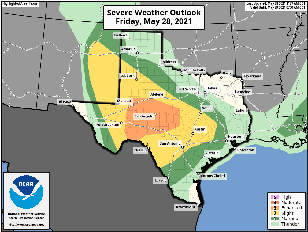
Attention turns to late Friday afternoon when the next wave of low pressure is forecast to move into West and Northwest Texas, causing the development of showers and thunderstorms across much of West Texas, the Edwards Plateau and the northern Hill Country. The leading edge of the rain and storm activity is predicted to spread south and southeast into the Austin/Interstate 35 corridor early this evening and across the rest of Central Texas in the late evening. The shower and storms are forecast to spread into the coastal region after midnight. With a moderately unstable atmosphere in place, some of the storms this evening and overnight may become strong or severe. The Storm Prediction Center has placed the western and central Hill Country, the Edwards Plateau and parts of West Texas under an Enhanced Risk (a 3 out of 5 risk) for severe thunderstorms this afternoon through sunrise Saturday. Austin, the eastern Hill Country and most of Central Texas has been placed under a Slight Risk(a 2 out of 5 risk) for severe thunderstorms through early Saturday. The middle Texas coast has been placed under a Marginal Risk (a 1 out of 5 risk) for severe thunderstorms overnight. Large hail and damaging winds will be the primary severe weather threats, although a couple of isolated tornadoes cannot be ruled out.
Showers and thunderstorms are forecast to persist across much of the area Friday night till after sunrise Saturday. Pockets of moderate to heavy rain will be possible across the Hill Country and parts of Central Texas. Rainfall forecasts call for widespread totals to near 2 inches across a large part of the Hill Country. Isolated totals over more than 3 inches will be possible. Across Central Texas, totals are forecast to be near 1-2 inches, while totals look stay under an inch across the coastal plains.
The outlook for Saturday calls for a 40-50 percent chance for scattered rain showers and isolated thunderstorms across the region as a weak cold front stalls out from around Big Spring to north of Houston. Periods of light to moderate rain and scattered thunderstorms are forecast. Totals are forecast to stay under a half inch. Expect a partly to mostly cloudy sky with high temperatures in the low and mid-80s. The chance for rain is forecast to diminish late Saturday afternoon into Saturday evening.
A break in the rainy pattern is forecast for Sunday as a stable atmosphere sets up behind Saturday’s activity. Expect a mostly sunny to partly cloudy sky with high temperatures mostly in the mid-80s. Some of Friday’s forecast solutions indicate a large complex of rain and thunderstorms will develop along the Dry Line across West Texas late Sunday afternoon when another wave of low pressure drops southeast. These solutions call for the complex of rain and storms to track southeast over parts of the Hill Country Sunday evening into Sunday night as it weakens. Should this system develop as forecast, it could bring another quarter to half inch of rain to parts of the Hill Country Sunday night.
The outlook for Memorial Day calls for a partly to mostly cloudy sky. There will be a 30-40 percent chance for scattered rain showers and thunderstorms Monday afternoon and Monday evening as another wave of low pressure tracks into Northwest Texas. Rain amounts are forecast to be around a half inch, or less. High temperatures Monday are forecast to be in the mid-80s.
The unsettled pattern looks to continue next Tuesday through Thursday when a larger trough of low pressure dips south out of the southern Rockies and moves across the southern Plains states. This system is forecast to cause periods rain showers and thunderstorms across the region, with the most significant rains occurring Tuesday and Wednesday. Rainfall over this period is currently forecast to average more than an inch. High temperatures are forecast to be mostly in the mid-80s.
Forecasts call for the chance for rain to decrease next Friday into next weekend. However, a slight chance for rain will continue each day. High temperatures are forecast to be in the mid and upper 80s.
Wishing everyone a safe Memorial Day weekend. Keep a particularly close eye on weather developments this afternoon and tonight.
Bob
Social Media