Forecasters are still anticipating quite a few changes in the weather beginning Thanksgiving, continuing through the upcoming weekend.
Wednesday’s weather maps showed a large trough of low pressure in the upper atmosphere sinking southeast out of the central Rockies. In advance of the trough, considerable middle and high-level clouds are spreading into Texas out of the eastern Pacific. In addition, lower-level clouds are spreading north from the Gulf. Altogether, today’s sky is expected to be partly to mostly cloudy. No rain is forecast but conditions will be quite breezy. Expect southerly winds at 10-20 mph, with occasional gusts to 30 mph. Afternoon temperatures are predicted to warm into the mid and upper 70s.
Drizzle, scattered rain showers and even an isolated thunderstorm or two is forecast to develop across the region late this evening, continuing overnight as the atmosphere becomes increasingly moist and unstable.
A Canadian cold front associated with the upper trough is forecast to track southeast across the region late Wednesday night through Thursday morning. The front is predicted to reach the northern Hill Country a couple of hours before daybreak Thursday, the I-35 corridor around 8 or 9 am, the La Grange area in the late morning and the coast in the early afternoon.
Showers and a few isolated thunderstorms are predicted across the Hill Country as the front moves through the area. The rain should end here by about mid-morning. Rain amounts are forecast to generally average around a quarter inch or less.
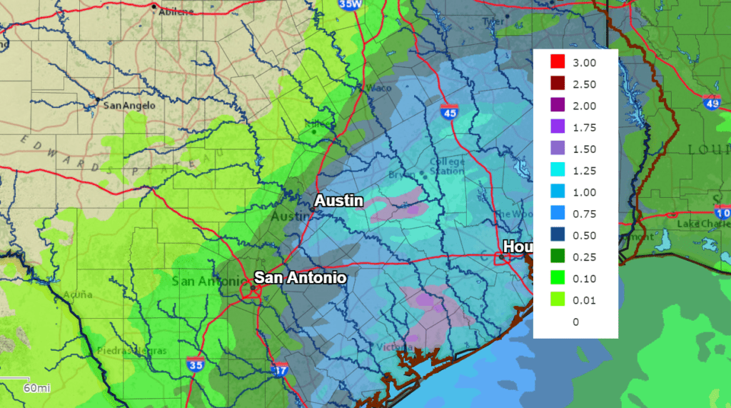
A more widespread coverage of rain showers and thunderstorms is forecast over the area from the Austin/Interstate 35 corridor, southeast to the coast. Here, some of the rain may become locally heavy. The rain is forecast to taper off across Central Texas by about midday and the coastal region by late afternoon. Rain amounts are forecast to generally average around 1-1.25 inches, with isolated totals to around 2 inches possible.
NWS Rainfall Forecast to the Period 6 am Wednesday through 6 am Friday:
The sky is forecast to become mostly sunny across the Hill Country Thursday morning, while mostly sunny conditions should develop across the Austin/Central Texas region by early afternoon. Thanksgiving Day weather will be breezy and noticeably cooler! Expect northerly winds at 15-25 mph, with gusts to 35 mph. Afternoon temperatures will only warm to around 60-62 degrees.
Expect a mostly clear sky and cold temperatures Thursday night. Freezing temperatures will be possible across many of the low valleys throughout the Hill Country. Lows Friday morning will include the mid-30s across the Hill Country, the upper 30s to around 40 degrees across Central Texas, with low and mid-40s across the coastal plains.
Friday’s weather will include a partly to mostly cloudy sky as high-level clouds spread east out of Mexico. Temperatures will be cool, with highs near 58-60 degrees. Expect light northeasterly winds. Lows Saturday morning will generally be in the low 40s.
The outlook for Saturday calls for a mostly cloudy to overcast sky as a large area of mid-level clouds spreads into Texas ahead of a weak area of low pressure moving northeast out of northern Mexico. There will be a 30-40 percent chance for light rain showers across the entire region Saturday afternoon, continuing through Saturday night. The chance for rain should taper off from west to east late Saturday night as the trough exits the region. Rain amounts through the period are forecast to average around a tenth of an inch across the Hill Country, be close to a quarter inch across Central Texas and total up to a half inch across the coastal plains. Highs Saturday will be near 58-62 degrees. Lows Sunday morning will range from the mid-40s west, to the low 50s near the coast.
Sunday’s weather is shaping up to be mostly sunny and slightly warmer, with highs in the mid-60s.
The outlook for next week calls for mostly sunny weather Monday and Tuesday. Highs will be in the 60s, with lows in the 40s. We will likely see another chance for light rain developing sometime late next week when another trough of low pressure lifts north from Baja, California. No significant change in the temperature is forecast mid to late week.
Have a safe and happy Thanksgiving!
Bob
Social Media