The weather is quiet across Texas as we close out the workweek. The cold front which pushed across our area late Wednesday is now stationary along the middle Texas coast. Dry and slightly cooler air spreading south behind the front allowed temperatures early Friday morning to cool into the 40s and 50s across the Hill Country and Central Texas regions. According to LCRA’s Hydromet, readings across the western and northern Hill Country reached the mid-40s, with one gauge in northern Menard County reaching 42 degrees! These fall-like readings are a preview of much cooler air that will be headed our direction the first half of next week.
A mostly sunny sky and warm temperatures will be in place this afternoon as the cold front along the coast begins to slowly lift back to the north. High temperatures will generally be around 88-91 degrees. Expect east and southeasterly breezes at 5-10 mph. Clouds and humidity will increase Friday evening and Friday night as southerly breezes pull moisture inland from the Gulf. Lows Saturday morning will be in the mid and upper 60s.
Saturday looks to start off with a partly to mostly cloudy sky, but the clouds will give way to a mostly sunny sky late morning through afternoon. Breezy and warm conditions are forecast, with temperatures predicted to top out around 90-92 degrees. Expect a south wind at 10-20 mph, with occasional gusts to 25 mph. Lows Sunday morning will be in the upper 60s.
Changes in the weather will begin to take place Sunday.
A deep trough of low pressure traveling east across the Great Lakes region this weekend will be helping to push a strong Canadian cold south into Texas. Forecasts call for the cold front to push south of the Red River just after sunrise Sunday morning, reaching the northern Hill Country sometime late Sunday afternoon. The front is predicted to sink south across the rest of the Hill Country and the Central Texas region Sunday evening, reaching the coastal plains after midnight Sunday night.
In advance the cold front, Sunday’s weather is expected to be partly cloudy and warm. However, Increasing moisture levels ahead of the cold front will cause a 30-40 percent chance for scattered afternoon rain showers and isolated thunderstorms. High temperatures are forecast to be near 88-90 degrees.
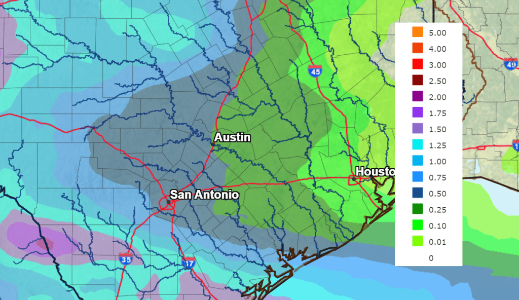
The chance for rain and thunderstorms will increase to 60 percent Sunday evening and Sunday night as the cold front presses south through the region. The chance for rain and isolated thunderstorms is forecast to continue Monday into Monday evening as a trough of low pressure over the Four Corners region tracks northeast to the southern Plains states Monday into Monday, creating an overrunning pattern across much of Texas. Waves of rain showers and isolated thunderstorms can be expected Monday, with the rain then tapering off from northwest to southeast Monday evening. Forecasts call for the highest moisture content Monday to reside across the Rio Grande Plains and the Edwards Plateau region, with lower values expected across Central and Southeast Texas. With that in mind, rain totals Sunday through Monday are forecast to be heaviest out west and lightest towards the east. The National Weather Service’s rainfall forecast For Sunday and Monday calls for totals between 0.5 and 1 inch for locations across the Hill Country, and between 0.25 and 0.5 inch for areas along and east of Interstate 35.
NWS Rainfall Forecast for the Period 7 pm Friday through 7 pm Wednesday:
Much cooler air will begin spreading into our area behind the cold front Sunday night with the cool air expected to stick around through late next week. Tuesday and Wednesday nights are shaping up to be coolest nights of the week.
- Lows Monday morning will range from the upper 50s west, to the upper 60s near the coast.
- Lows Tuesday morning are forecast to range from the upper 40s west, the upper 50s near the coast.
- Lows Wednesday and Thursday mornings will include the low 40s across the Hill Country, the mid-40s across Central Texas and the upper 40s across the coastal plains.
- Lows Friday morning are forecast to be close to 50 degrees.
- High temperatures Monday are forecast to be in the upper 60s and low 70s across the Hill Country and Central Texas, and in the mid to upper 70s towards the coast.
- High temperatures Tuesday and Wednesday are forecast to be near 70 degrees.
- High temperatures Thursday and Friday are predicted to be around 78-82 degrees.
Sunny and dry weather is forecast Tuesday through Friday. Sunny and warmer weather will follow next weekend with highs returning to the mid-80s.
Tropical Weather Outlook
Forecasters continue to keep a close watch on Tropical Storm Karl in the Bay of Campeche. Karl poses no threat to Texas. As of 1 pm CDT, the center of Tropical Storm Karl was located about 85 miles northwest of Ciudad Del Carmen, Mexico. Karl was moving toward the south near 6 mph. A southward or south-southwestward motion is expected tonight and early Saturday over the Bay of Campeche. On the forecast track, the center of Karl should reach the coast of southern Mexico late Friday night or early Saturday.
Data from an Air Force Reserve Hurricane Hunter aircraft indicated maximum sustained winds had decreased to near 40 mph with higher gusts. Little change in strength is expected before the center of Karl reaches the coast. Steady weakening is expected after the storm crosses the coastline, and the system is forecast to dissipate over southern Mexico by Saturday night.
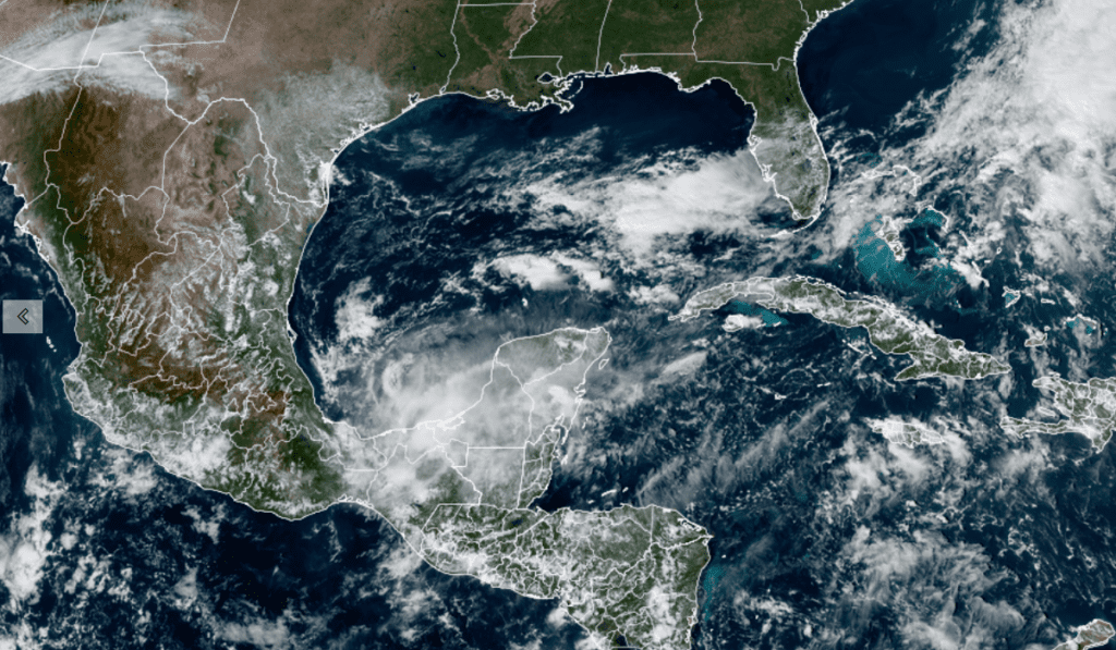
NOAA/CIRA/RAMMB 10-14-2022 1:40 pm CDT
Forecasters are monitoring an area of showers and thunderstorms associated with a tropical wave out across the far eastern tropical Atlantic, several hundred miles southwest of the Cabo Verde Islands. The showers and thunderstorm activity actually decreased in intensity Friday morning. Environmental conditions appear only marginally conducive for gradual development through the weekend while the wave moves generally westward at about 10 mph. Further development will become unlikely by early next week due to increasing upper-level winds. NHC forecasters are giving this system just a 10 percent chance for tropical development over the next 5 days.
Elsewhere conditions are quiet and tropical cyclone development is not expected for the next 5 days.
Mars has Returned to the Nighttime Sky
After spending several months in the early morning sky, Mars has returned to the evening sky. Mars, magnitude –0.9, and quite bright, is located in eastern Taurus and clears the east-northeast horizon around 9 pm. The planet gains altitude for the rest of the night.
Orange Aldebaran sparkles to Mars’s upper right, by about a fist and a half, at magnitude +0.9. Which of the two seems to you to have the slightly deeper tint?
Bob
Social Media