A wet and unsettled weather pattern remains in place across our region. Since late last week, Central and South Texas has been situated in a break between ridges of high pressure located over the eastern Gulf of Mexico and northwestern Mexico. Considerable moisture spreading north from the Gulf between the ridges has resulted in periods of moderate to heavy rain for areas from the eastern Hill Country to the middle Texas coast. The highest 7-day totals have occurred across the coastal plains region where most locations received between 3 and 7 inches of rain.
Early this afternoon, radar showed a large area of light to moderate rain showers and scattered thunderstorms spreading north across Central Texas, the eastern Hill Country and the coastal plains region. A wave of low pressure tracking north out of northeastern Mexico is helping pull a slug of moist, tropical air into the region, resulting in widespread rain. Periods of rain showers and thunderstorms are forecast to continue this afternoon, with the activity decreasing this evening. The probability for rain will only be around 30 percent for the northern and western Hill Country and near 70 percent across the rest of the area. Today’s rain totals will generally stay below a half inch across the Hill Country. Elsewhere, most totals should be between 0.5 and 1.5 inches, with isolated totals to near 3 inches possible. Today’s temperature is forecast to top out in the upper 80s.
The weather looks to trend drier on Saturday as the ridge high pressure over the eastern Gulf expands to the west, closing the gap between the two ridges. There will be a slight chance for a few spotty afternoon rain showers for locations east of Interstate 35 due to some lingering tropical moisture. However, most locations should be partly cloudy, dry and breezy. High temperatures Saturday will generally be near 90-92 degrees. Expect a south wind at 10-15 mph, with occasional gusts to 25 mph.
There will be a slight chance for a few spotty rain showers and isolated thunderstorms Sunday when a weak trough of low pressure tracks to the east out of West Texas. The probability for rain will be near 20 percent and most rain amounts should total less than a quarter inch. Expect a partly to mostly cloudy sky with high temperatures in the low 90s. Breezy south winds at 10-15 mph will continue.
A generally dry weather pattern is forecast across the region next Monday through Friday as the ridge of high pressure centered over the Gulf shifts west to Texas. A few spotty afternoon rain showers will still be possible across the coastal plains region, but most other areas look to stay dry. Expect a partly cloudy to mostly sunny sky each day. High temperatures across the Hill Country and Central Texas are predicted to be in the mid-90s Monday through Wednesday, rising to the upper 90s Thursday and Friday. High temperatures across the coastal plains will be mostly in the low 90s.
The outlook for the Fourth of July weekend calls for more partly cloudy and hot weather. However, locations east of Interstate 35 could see a slight chance for rain and thunderstorms on both days as the center of high pressure ridge shifts to Arizona and New Mexico, opening the door for some disturbances to slide southeast out of Colorado. Confidence in this threat for rain is currently low, so I certainly wouldn’t change any outdoor plans. High temperatures look to be in the mid and upper 90s.
The first full week of July is shaping up to be partly cloudy, hot and generally dry. That slight chance for rain showers over the weekend will continue into the first part of the week. Otherwise, expect very typical July-type weather with high temperatures in the upper 90s.
Tropical Weather Outlook
Weather conditions are quiet across the tropical Atlantic, the Caribbean Sea and the Gulf of Mexico. A large belt of Saharan just covers much of the tropical Atlantic between the west coast of Africa and the Greater Antilles.
Tropical cyclone development is not forecast for at least the next 5 days.
Saharan Dust Update
The large plume of Saharan dust that has been spreading west across the Caribbean and the Gulf of Mexico this week has made it to the Texas coast and is forecast to spread inland to Central and North Texas tonight and Saturday. At midday, hazy conditions and reduced visibility were being reported from Brownsville to Victoria, Houston and Beaumont.
The highest concentration of dust is forecast across our area Saturday, with conditions improving some on Sunday. The TCEQ reports that heavy amounts of African dust will expand across most of the state on Saturday. Due to the high amount of dust, the daily PM2.5 Air Quality Index is forecast to reach the lower to middle end of the “Unhealthy for Sensitive Groups” range in parts of the Austin, Brownsville-McAllen, Corpus Christi, Dallas-Fort Worth, Laredo, Victoria, and Waco-Killeen areas. People with respiratory issues are advised to stay indoors as much as possible.
On Sunday, the daily PM2.5 Air Quality Index is forecast to reach the middle to upper end of the “Moderate” range in parts of the Austin, Big Bend, Brownsville-McAllen, Dallas-Fort Worth, Laredo, San Antonio, Tyler-Longview, and Waco-Killeen areas.
The outlook for next week calls for moderate amounts of Saharan dust to continue spreading across Central Texas throughout the week. Look for more colorful sunrises and sunsets along with a more grey colored sky.
A visible true-color satellite image from 1 pm Friday:
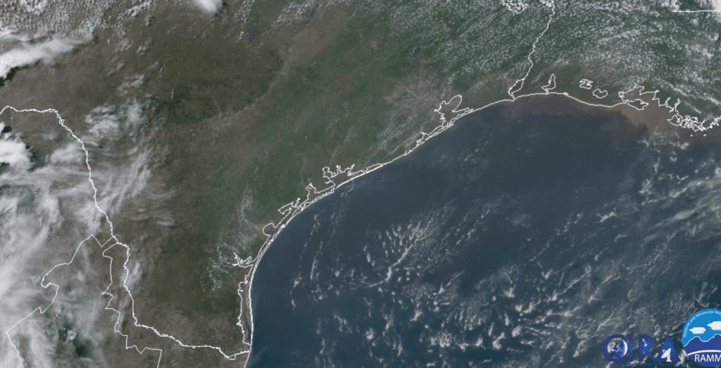
RAMMB-CIRA 06/26/20 1:00 pm CDT
Comet NEOWISE
This year has seen two comets make their way through the solar system, only to disintegrate as they approached the Sun. Recently NASA’s NEOWISE telescope discovered a new comet which is also plunging toward the sun for a close encounter near the orbit of Mercury on July 3rd. Observations from NASA’s Solar and Heliospheric Observatory’s (SOHO) telescope, indicate the comet is looking healthy and intact. Recently, the comet brightened to magnitude +2.4. This means it is likely to be an easy naked-eye object when it emerges from the sun’s glare in mid-July. Stay tuned for more updates. Hopefully, the third time (comet) will be the charm to seeing a naked-eye comet.
Have a good weekend.
Bob
Social Media