A wet weather pattern has begun take shape as a large plume of deep, tropical moisture spreads inland off the Gulf of Mexico. This area of moisture is being driven inland by a non-tropical area of low pressure located just off the lower Texas coast. As the first wave of moisture spread inland Sunday, widespread showers and tropical downpours developed across the region, with some amounts totaling between 1 and 3 inches. Forecasts call for considerable tropical moisture to spread across the region this afternoon through Tuesday, followed by decreasing moisture levels Wednesday through Friday.
This afternoon through Tuesday, expect periods of showers and scattered thunderstorms—especially in the afternoon and evening. Due to the tropical nature of the atmosphere, some of the rain may at times be quite heavy. Rainfall forecasts between this afternoon and Wednesday morning call for general totals of 0.5 to 1 inch across the Hill Country and most of Central Texas, with totals of 1-2 inches expected across the coastal plains. Isolated totals 2-4 inches will be possible. The sky will be mostly cloudy both days, keeping high temperatures mostly in the mid and upper 80s.
The chance for widespread rain is forecast to decrease beginning Wednesday as the flow of moisture off the Gulf slows. At the same time, a weak ridge of high pressure in the upper atmosphere is forecast to spread over Texas out of the southeastern U.S. Mainly afternoon and evening showers and thunderstorms are predicted, The probability for rain is forecast to be near 50 percent Wednesday, decreasing to around 30 percent Thursday and Friday. Daily rain amounts Wednesday through Friday are forecast to average between 0.25 and 0.5 inches. High temperatures Wednesday through Friday are forecast to be around 90-93 degrees.
The chance for rain is forecast to increase again this weekend as an unusual cold front sinks south and stalls somewhere around the Red River. Forecasts call for showers and thunderstorms to develop along the front, with the activity tracking south into Central and South Texas Saturday through Monday. The highest probability for rain is expected to occur on Sunday, Independence Day—near 60 percent. Totals of 0.25 to 0.5 inches are forecast on all three days. The holiday weekend is not expected to be a total washout, but do know there will be periods of rain and thunderstorms. High temperatures are forecast to be near 88-90 degrees.
The outlook for next week calls for scattered showers the first half of the week, followed by dry and warmer weather Thursday and Friday, with high temperatures returning to the mid-90s.
Tropical Weather Outlook
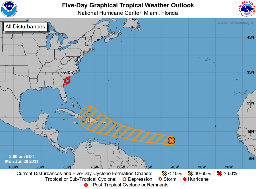
An area of disturbed weather and associated low pressure system that has been in place off the coast of South Carolina the past couple of days has developed into a tropical storm. At 4:00 PM CDT, the center of Tropical Storm Danny was centered about 35 miles south-southwest of Charleston, South Carolina. Danny is moving toward the west-northwest near 16 mph and this general motion is expected to continue into Tuesday. On the forecast track, Danny will make landfall along the southern coast of South Carolina early Monday evening, and move into east-central Georgia late Monday night and early Tuesday morning.
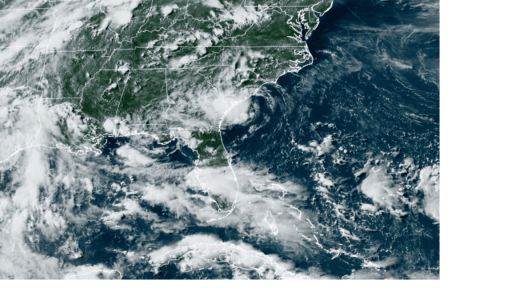
Colorado State University/RAMMB 06/28/2021 4:20 pm CDT
Data from NOAA Doppler radars and reconnaissance aircraft indicate that maximum sustained winds have increased to near 45 mph with higher gusts. No change in strength is expected until landfall occurs in a few hours. Rapid weakening is forecast after Danny moves inland.
Elsewhere, a broad area of low pressure associated with a tropical wave is producing a small cluster of showers and thunderstorms over the central tropical Atlantic Ocean. Some slow development is possible through the end of the week while this system moves quickly westward to west-northwestward at about 20 mph, likely reaching the Lesser Antilles Wednesday night. NHC forecasters are giving this system a 40 percent chance for tropical development over the next 5 days.
Bob
Social Media