An unsettled weather pattern is beginning to take shape that looks to bring our region periods of showers and thunderstorms beginning late this afternoon and evening, continuing through late Wednesday afternoon. Scattered strong to severe thunderstorms will be possible across parts of the Hill Country and Central Texas regions this evening and across the entire region on Tuesday.
Monday morning’s weather maps showed a cold front bisecting the state, stretching from Longview to just south of Austin to near Rocksprings. Temperatures behind the front were generally in the 60s and 50s, while readings to the south were in the 70s and 80s. Forecasts call for the cold front to sag very slowly to the south this afternoon, pulling up stationary somewhere between La Grange and Columbus tonight. Meanwhile, all eyes are on a wave of low pressure in the middle and upper atmosphere located over northern Mexico. This feature is forecast to move across Texas late tonight into Tuesday and is predicted to initiate the development of thunderstorms along with overrunning clouds and widespread showers.
For this afternoon, expect the sky to remain mostly cloudy across the Hill Country and Central Texas regions, while the sky will become partly cloudy across the coastal plains. A couple of isolated rain showers and thunderstorms will be possible, but nothing organized is expected. High temperatures will range from the upper 60s across the northern Hill Country to the mid and upper 70s across Central Texas to the upper 80s across the coastal.
Mid to late this afternoon, high-resolution forecasts call thunderstorms to develop around Del Rio and across the western Edwards Plateau. These storms will have a good potential to become severe, producing large hail and damaging winds as they track generally to the east and northeast across the Hill Country and parts of Central Texas. The Storm Prediction Center has placed the area west of a Menard to Fredericksburg to San Antonio line under a Slight Risk (a 2 out of 5 risk) for severe thunderstorms overnight. SPC has placed the eastern Hill Country, all of Central Texas and the coastal plains region north of US 59 under a Marginal Risk (a 1 out of 5 risk) for severe storms this evening and overnight. Do note the area from Del Rio to Kerrville to Eagle Pass has been placed under an Enhanced Risk (a 3 out of 5 risk) for severe storms this afternoon and overnight. In addition to the threat for severe weather, the scattered storms are expected to produce rain totals averaging between 0.5 and 1 inch, with isolated totals of 2-3 inches. Most of the thunderstorms are predicted to diminish late tonight. The probability for rain this evening and overnight will be near 50-60 percent.
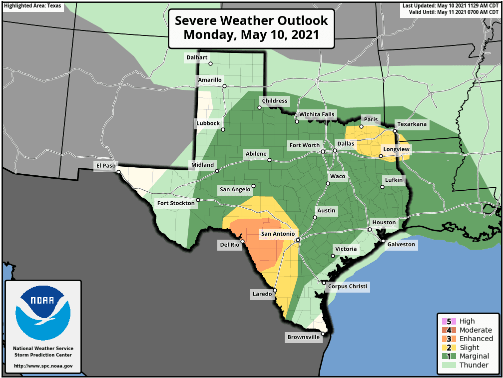
Tuesday and Tuesday night’s weather is shaping up to be cloudy with periods of rain and scattered thunderstorms as an overrunning pattern sets up behind the cold front. Forecasts call for the development of widespread showers and thunderstorms across much of the Hill Country and Central Texas regions Tuesday morning, with the activity persisting and slowly shifting south to include the middle Texas coast Tuesday afternoon and Tuesday night. Some of scattered thunderstorms may be strong to severe, capable of producing large hail. The Storm Prediction Center has placed the entire region under a Marginal Risk (a 1 out of 5 risk) for severe thunderstorms Tuesday through Tuesday night. Rain amounts Tuesday through Tuesday night are forecast to generally average between 1 and 2 inches, with a few isolated heavier totals possible. High temperatures will be in the low and mid-70s, with middle 80s expected towards the coast.
For Wednesday, periods of rain showers and isolated thunderstorms will continue as the overrunning pattern persists. The chance for rain is forecast to diminish from west to east late Wednesday afternoon into Wednesday evening as the upper trough finally exits to the east. The threat for severe storms Wednesday is expected to be low. Rain amounts Wednesday are predicted to average around a half inch. Temperatures are shaping up be noticeably cooler as a second cold front moves through the area. Expect high temperatures in the upper 60s across the Hill Country and in the upper 60s to low 70s across Central Texas and the mid-70s towards the coast.
Rain totals between this afternoon and Wednesday evening are forecast to generally average between 1 and 2 inches across the Hill Country and the Interstate 35 corridor. However, a few isolated totals of 3-4 inches will possible—especially for areas that see strong storms Monday evening. Slightly lower totals are forecast for the area between the I-35 and the middle Texas coast.
NWS Rainfall Forecast for the Period 7 pm Monday through 7 pm Thursday:

Lows Thursday morning will include the low and mid-50s across the Hill Country, the upper 50s across Central Texas and the low 60s near the coast.
Mostly sunny weather is forecast Thursday through Friday as a stable ridge of high pressure spreads over the area out of Mexico. High temperatures are predicted to be in the mid-70s Thursday and close to 80 degrees Friday. Lows Friday morning will range from the low 50s Hill Country to the low 60s near the coast.
The outlook for the upcoming weekend calls for mostly sunny weather Saturday, with a high temperature in the low 80s. A mostly cloudy sky is forecast Sunday. There looks to be 30-40 percent chance for scattered showers and thunderstorms Sunday as moisture returns ahead of a small trough moving out of Mexico. Rain amounts are forecast to average between a quarter and a half inch. Expect a high temperature in the mid-80s.
Looking out into next week, today’s forecasts call for the weather pattern to stay fairly unsettled throughout the week. A series of low pressure troughs out of the Pacific are forecast to track east and move across Texas throughout the week. These systems are forecast to cause periods of showers and scattered thunderstorms. High temperatures are predicted to generally be in the mid to upper 80s.
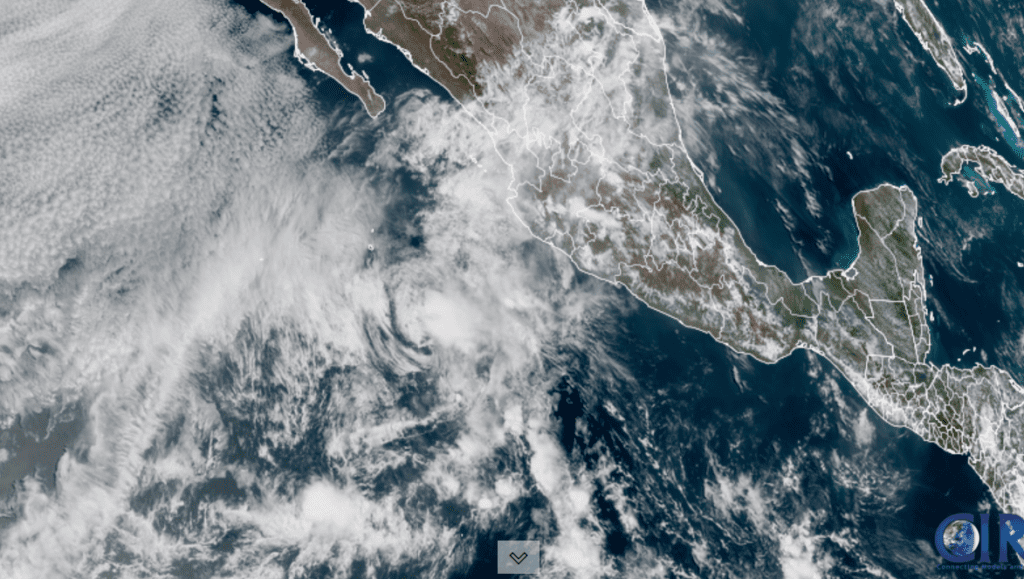
The First Tropical Storm of the Season Forms in the Eastern Pacific
Tropical Storms Andres developed in the eastern tropical Pacific on Sunday. As of 10 am CDT Monday, the center of Tropical Storm Andres was located about 520 miles south of the southern tip of Baja, California. Andres was moving toward the north-northwest near 6 mph. A turn to the northwest and west-northwest is expected on Tuesday, followed by a westward motion on Wednesday.
Maximum sustained winds are near 40 mph with higher gusts. Weakening is expected to begin later today, and Andres is forecast to become a remnant low on Tuesday. Andres is not expected to have an impact on any land areas.
Have a good week.
Bob
Social Media