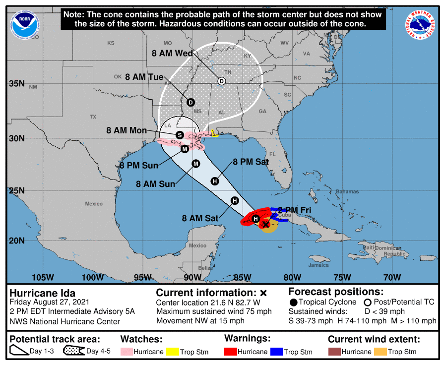
All eyes will be on Hurricane Ida this weekend, as the storm tracks toward the central or southeastern coast of Louisiana. Over the past 24 hours, confidence has increased substantially in the storm’s forecast track and it appears now that a path towards the Texas coast is very remote.
As of 1 pm Friday, Tropical Storm Ida was located across the northwestern Caribbean Sea, just south of western Cuba. Ida just made landfall on the Isle of Youth. Ida was moving toward the northwest near 15 mph, and this general motion should continue over the next few days. Reports from Air Force Reserve reconnaissance aircraft indicate the maximum sustained winds are near 75 mph with higher gusts. Additional strengthening is forecast before the center moves over western Cuba late Friday. Steady to rapid strengthening is expected when Ida moves over the southeastern and central Gulf of Mexico over the weekend, and Ida is expected to be a major hurricane when it approaches the northern Gulf coast late Sunday. On the latest forecast track, the center of Ida will pass over the Isle of Youth this afternoon, move over western Cuba late Friday afternoon, and move over the southeastern and central Gulf of Mexico tonight and Saturday. Ida is forecast to make landfall along the U.S. northern Gulf coast on Sunday. Once Inland, Ida is forecast to track to the north and northeast across the Mississippi and Tennessee Valley regions.
A Hurricane Watch is in effect for the Gulf coast, from Cameron, Louisiana to the Mississippi/Alabama border, including Lake Pontchartrain, Lake Maurepas, and Metropolitan New Orleans.
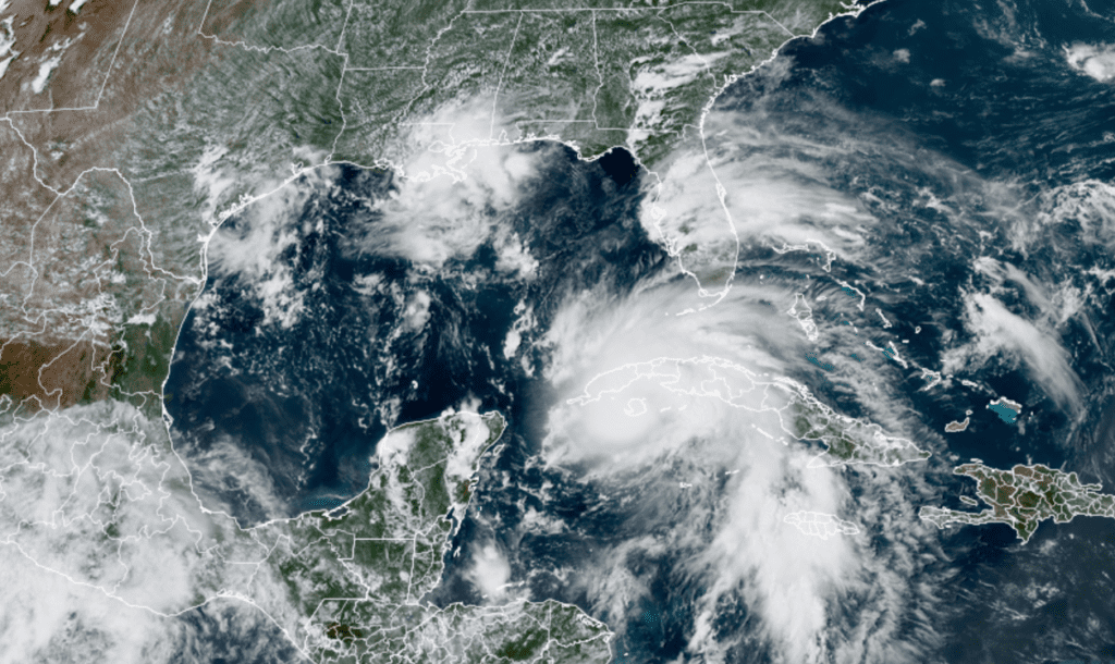
NOAA/Colorado State University/RAMMB 08/27/2021 2:00 pm CDT
Back across Central and South Texas, a fairly active weather pattern, unrelated to Ida, is forecast this afternoon and Saturday. Friday’s weather maps showed a non-tropical wave of low pressure pushing inland along the middle and upper Texas coast. This low is helping push a large area of tropical moisture well inland. The increased moisture and a slightly unstable atmosphere is expected to cause the development of scattered rain showers and thunderstorms across the region this afternoon and again on Saturday. The probability for rain will be near 20/30 percent across the western and northern Hill Country and near 40/50 percent at most other locations. Rain amounts on each day are forecast to average between a quarter and a half inch, with isolated downpours of 1-2 inches possible. Expect a partly cloudy sky both days, with high temperatures in the mid-90s.
For Sunday, lingering tropical moisture is forecast to cause additional scattered rain showers and thunderstorms across the region. However, areal coverage is expected to be a little less, with the probability for rain at any given location predicted to be near 30 percent. Sunday’s temperature is forecast to again reach the mid-90s. Winds on Sunday are forecast to be out of the northeast at around 5-10 mph, due to the outer circulation from Ida.
Sunny, hot and generally dry weather is forecast next Monday through Friday as the remnants of Ida take off to the mid-Atlantic and a moderate ridge of high pressure sets up across the northern Texas and the southern Plains states. There will be a slight chance for showers each afternoon across the coastal plains region, while most other locations stay dry. Daily rain amounts look to average less than a quarter inch.
- High temperatures Monday are predicted to be in the upper 90s, with mid-90s expected towards the coast.
- High temperatures Tuesday and Wednesday are predicted to be near 98-100 degrees across the Hill Country and Central Texas regions and in the mid-90s towards the coast.
- High temperature Thursday and Friday are forecast to be in the upper 90s, with mid-90s expected towards the coast.
The early outlook for Labor Day weekend calls for mostly sunny and hot weather, with high temperatures in the mid and upper 90s. There will be a slight chance for showers—mainly for areas along and east of Interstate 35.
Longer-range forecasts call for a somewhat better chance for rain and less hot temperatures developing just after Labor Day.
Tropical Weather Outlook
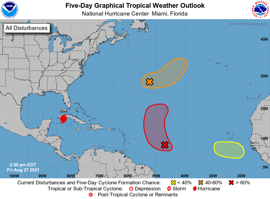
In addition to Tropical Storm Ida, National Hurricane Center forecasters are closely monitoring three other systems across the Atlantic. Neither feature poses a threat to the Gulf of Mexico or the Texas coast.
The first feature is an elongated area of low pressure located over the central Atlantic, about 600 miles east of Bermuda. This system is producing a large area of disorganized showers and thunderstorms. Environmental conditions are expected to be marginally conducive for development, and a tropical depression could form over the weekend. The system is expected to drift eastward through tonight and Saturday, then accelerate northeastward Sunday toward the central north Atlantic. NHC forecasters are giving this system a medium chance (a 60 percent chance) for tropical development over the next 5 days.
The second feature is located over the central tropical Atlantic, about midway between the Cabo Verde Islands and the Lesser Antilles. Here, a tropical wave is producing an area of limited showers and thunderstorms. Gradual development of this system is expected and a tropical depression is likely to form during the next couple of days. However, the system is forecast to move into an environment of stronger upper-level winds and slightly cooler waters early next week. The disturbance is forecast to move west-northwestward today, then turn northward into the central Atlantic Saturday. NHC forecasters are giving the system a high chance (an 80 percent chance) for tropical development over the next 5 days.
Finally, the third feature is a tropical wave that is forecast to emerge off of the west African coast by the middle of next week. Afterwards, environmental conditions appear marginally conducive for gradual development toward the end of next week as the system moves west-northwestward to northwestward at 10 to 15 mph. NHC forecasters are giving this system a slight chance (a 20 percent chance) for tropical development over the next 5 days.
Enjoy this last weekend of meteorological summer!
Bob
Social Media