It’s been quite a week of weather for Texas and Louisiana, with tropical threats from hurricanes Marco and Laura. With those threats now behind us, our very hot August weather pattern is resuming at full force. Friday’s morning’s weather maps showed the remnants of Laura have tracked north to the Middle Mississippi river valley. Meanwhile, the large ridge of high pressure which has been parked over the Southwestern U.S. for the past couple of weeks is spreading back east to Texas and the southern Plains states. With the ridge over our region, another period of very hot weather is developing. Fortunately, this upcoming period of extremely hot temperatures is only expected to last into the first half of next week. Forecasts call for the heat ridge to weaken early next week as a large trough of low pressure begins to develop south out of western Canada. This trough and its associated cold front is expected to bring “less hot” and somewhat cooler temperatures to our region the second half of next week, continuing through the Labor Day weekend.
This afternoon through Monday, a sunny , very hot and generally dry weather pattern will persist across our region. Daily high temperatures across the Hill Country and Central Texas regions are predicted to be near 100-105 degrees. Across the coastal plains, high temperatures will be in the mid to upper 90s. Low temperatures will be mostly in the upper 70s. There will be a slight chance for a few isolated rain showers and thunderstorms each afternoon across the coastal plains region as the Sea Breeze remains active. Rain amounts should average less than a quarter inch.
Some changes in the pattern will begin to take place Tuesday as the ridge weakens and a cold front starts to sink south out of North Texas. The front is forecast to spread across Central Texas Tuesday and stall somewhere over the coastal plains Wednesday. Scattered rain showers and thunderstorms are predicted to develop ahead of and along the cold front Tuesday into Tuesday night, with a slight chance for rain lingering into Wednesday. Rain amounts are forecast to average around a half inch, with isolated heavier totals. High temperatures are forecast to be near 100 degrees Tuesday, falling to the mid and upper 90s on Wednesday.
The outlook for late next week and Labor Day weekend calls for mostly sunny and dry weather with less hot temperatures. Highs through the period are predicted to be mostly in the mid and upper 90s.
Tropical Weather Outlook
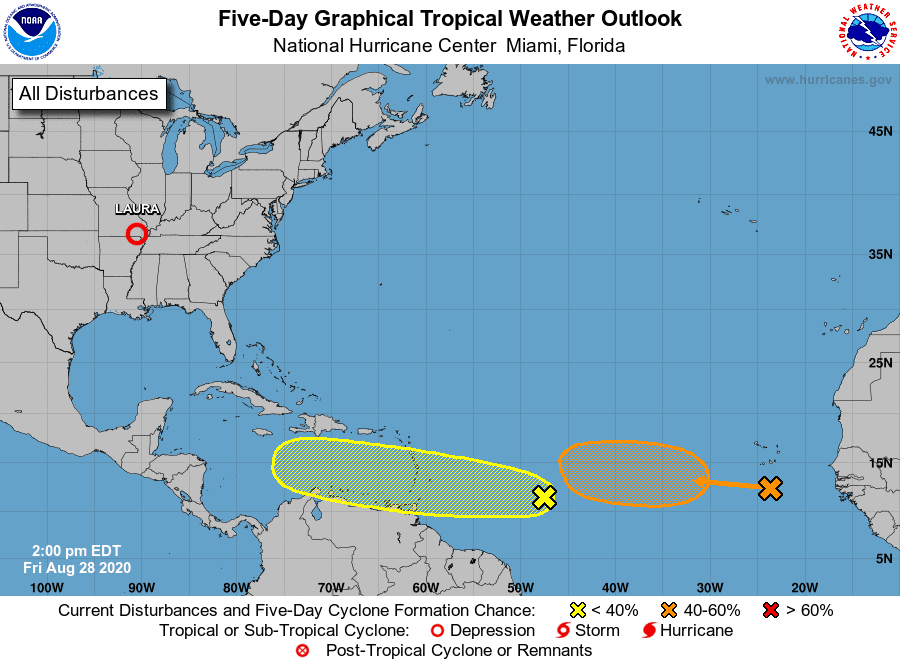
As of 10 am CDT, the center of Tropical Depression Laura was located over southeastern Missouri, about 85 miles northwest of Memphis, Tennessee. The depression was moving toward the east-northeast near 20 mph and this motion is expected to continue as Laura tracks along and south of the Ohio Valley through tonight. Maximum sustained winds were down to 30 mph with some occasional higher gusts. Eventually, the remains of Laura will cross the central Appalachians Saturday, before becoming absorbed by an approaching cold front that is forecast to move off the mid-Atlantic coastline by late Saturday.
National Hurricane Center forecasters are keeping an eye on a fairly strong tropical wave located about 850 miles east of the Windward Islands. This system is producing a disorganized area of showers and thunderstorms. Some gradual development of this system will be possible over the next several days as it moves westward at about 15 mph toward the eastern Caribbean islands. NHC forecasters are giving this system a 30 percent chance for tropical development over the next 5 days.
Satellite image show another strong tropical wave is located over the eastern Atlantic Ocean, just west of the Cabo Verde Islands. The northern part of the wave, which should move rapidly westward over the central Atlantic during the next few days, is not forecast to develop as it moves through an area of unfavorable environmental conditions. However, the southern part of the wave is expected to be nearly stationary south of the Cabo Verde Islands for the next several
days, and some development of this system is possible early next week when it begins to move slowly westward over the eastern and central tropical Atlantic. NHC forecasters are giving this system a 40 percent chance for tropical development over the next 5 days.
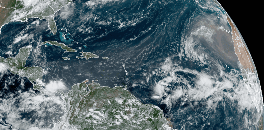
NOAA-RAMMB 08/28/2020 11:50 am CDT
Elsewhere, conditions are quiet and there are not features which pose a threat for tropical development over the next 5 days.
Evening Sky Show: Tonight, after the sun goes down, step outside and look toward the southern sky. The nearly full Moon will be there, forming a skinny triangle with Saturn and Jupiter. The three brightest objects in the evening sky are putting on a good show. Don’t miss it! By around 10 pm, brilliant Mars will be rising along the eastern horizon. It will emerge orange and be the brightest object in the eastern sky.
Have a good weekend.
Bob
Social Media