Weather conditions have been mostly cloudy, warm and breezy across the region this afternoon. Although the atmosphere is quite moist, a stable layer in lower atmosphere has been keeping a lid on shower and thunderstorm development across most of the area. However weather radar as of 3:30 pm showed scattered thunderstorms developing across the northern Hill Country, to the west and northwest of Brownwood. The Storm Prediction Center has issued a Tornado Watch for this general area through 9 pm. The watch includes, Brown, Coleman and Concho Counties.
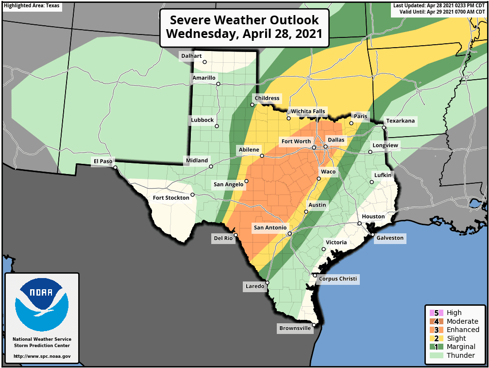
As of late Wednesday afternoon, thunderstorms were also beginning to develop along the mountains of northeastern Mexico, just to the west and north of Del Rio. High-resolution forecasts call for these thunderstorms to increase in intensity and areal coverage this afternoon and evening as winds in the middle atmosphere take the storms off to the northeast. The atmosphere over the Edwards Plateau and the Hill Country is quite moist and unstable. Many of these developing storms are forecast to quickly become severe as they spread into the Hill Country and close to the Austin/I-35 corridor late this evening and overnight. Forecasts call for numerous clusters of thunderstorms to develop and track across this area overnight. As mentioned at the top, the threat for severe storms has increased. The Storm Prediction Center has placed all of the Hill Country under an Enhanced Risk (a 3 out of 5 risk) for severe thunderstorms overnight. Austin and the Interstate 35 corridor has been placed under a Slight Risk (a 2 out of 5 risk) while a marginal risk (1 out of 5 risk) extends east to Seguin, Bastrop and Cameron. Severe storms are not forecast for the area southeast of La Grange.
The Storm Prediction Center recently issued a Tornado Watch for portions of the Hill Country and the Edwards Plateau until 11 pm. A tornado watch means conditions are favorable for tornadoes and severe thunderstorms in and close to the watch area. Persons in these areas should be on the lookout for threatening weather conditions and listen for later statements and possible warnings.
Large to very large hail, damaging winds to 80 mph and isolated tornadoes will all be possible from storms late this afternoon and overnight.
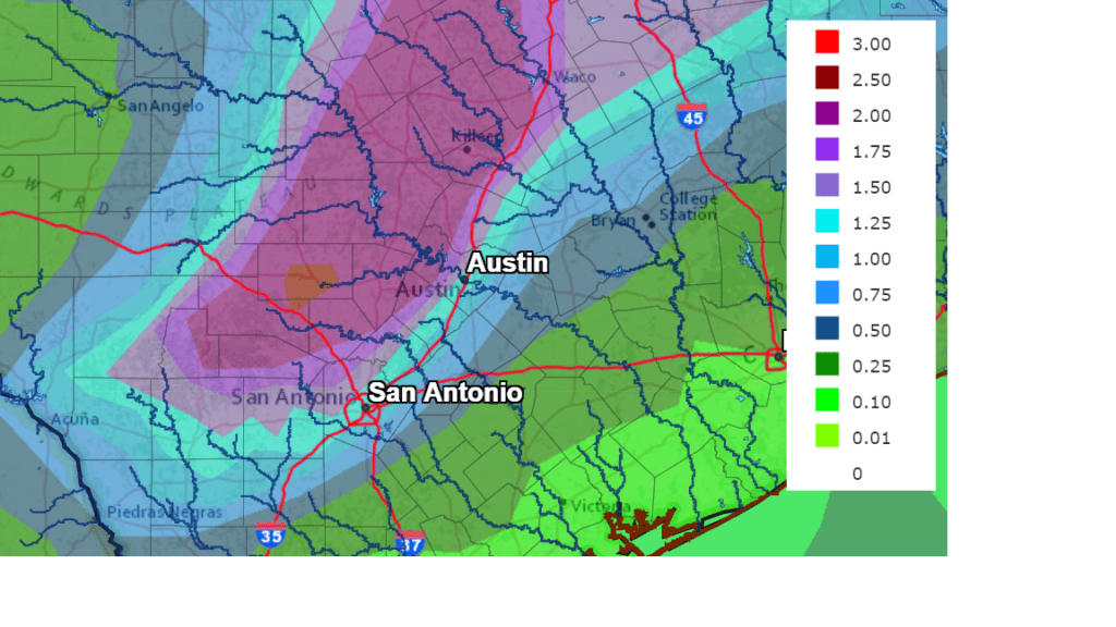
With numerous storms forecast to track northeast across the Hill Country overnight into Thursday morning, significant totals of rain will be possible—especially in locations where the storms may train over the same area. Rainfall forecasts through sunrise Thursday call for totals between 2 and 4 inches across the Hill Country, with a couple of isolated totals of 5-6 inches possible. The heaviest rains are forecast to stay west of the Austin/Interstate 35 corridor, where totals are forecast to average closer to a quarter to half inch. By sunrise Thursday, the heaviest rains are forecast to have exited our region off to the northeast.
NWS Rainfall Forecast for the Period 7 pm Wednesday through 7 pm Thursday:
Periods of rain showers and isolated thunderstorms are forecast across the region Thursday through Friday as a cold front pushes through the area and an overrunning pattern sets up. The chance for rain will be near 50 percent Thursday, decreasing to 30 percent on Friday. Additional rain amounts of a quarter to a half inch are forecast.
The chance for widespread rain showers and thunderstorms is forecast to increase Saturday into Saturday night as trough of low pressure lifts northeast out of Mexico and begins moving across Texas. The chance for rain looks to continue into Sunday, with the rain diminishing Sunday afternoon. The probability for rain will be near 50 percent Saturday and Saturday night, decreasing to 30 percent on Sunday. Forecasts call for additional rain amounts of 1-1.5 inches this weekend.
Dry and warm weather is forecast Monday, but a slight chance for rain will return to the forecast mid-week.
Bob
Social Media