…Strong and Severe Thunderstorms Forecast to Develop and Track East Across the Region Monday Afternoon into Monday Evening…
…Large Hail, Damaging Straight Line Thunderstorm Winds and a Couple of Tornadoes Will be Possible…]
A significant severe weather threat will be developing across the eastern Hill Country, the Austin/Central Texas area, and the coastal region this afternoon and this evening. Forecasters are monitoring a strong trough of low pressure that was located Monday morning over central New Mexico. This system is tracking to the east, pulling considerable moisture north from the Gulf. Ahead of this system, an advancing dry line out of West Texas, strong atmospheric lift, and a turning of the wind field with height are all expected to cause developing thunderstorms to become severe.
The Storm Prediction Center has placed the Austin area, the Interstate 35 corridor and all of Central Texas, plus Colorado and Wharton counties under an Enhanced Risk (a 3 out of 5 risk) for severe thunderstorms this afternoon through tonight. A Slight Risk (a 2 out of 5 risk) for severe thunderstorms covers the central and eastern Hill Country along with the area adjacent to the middle Texas coast.
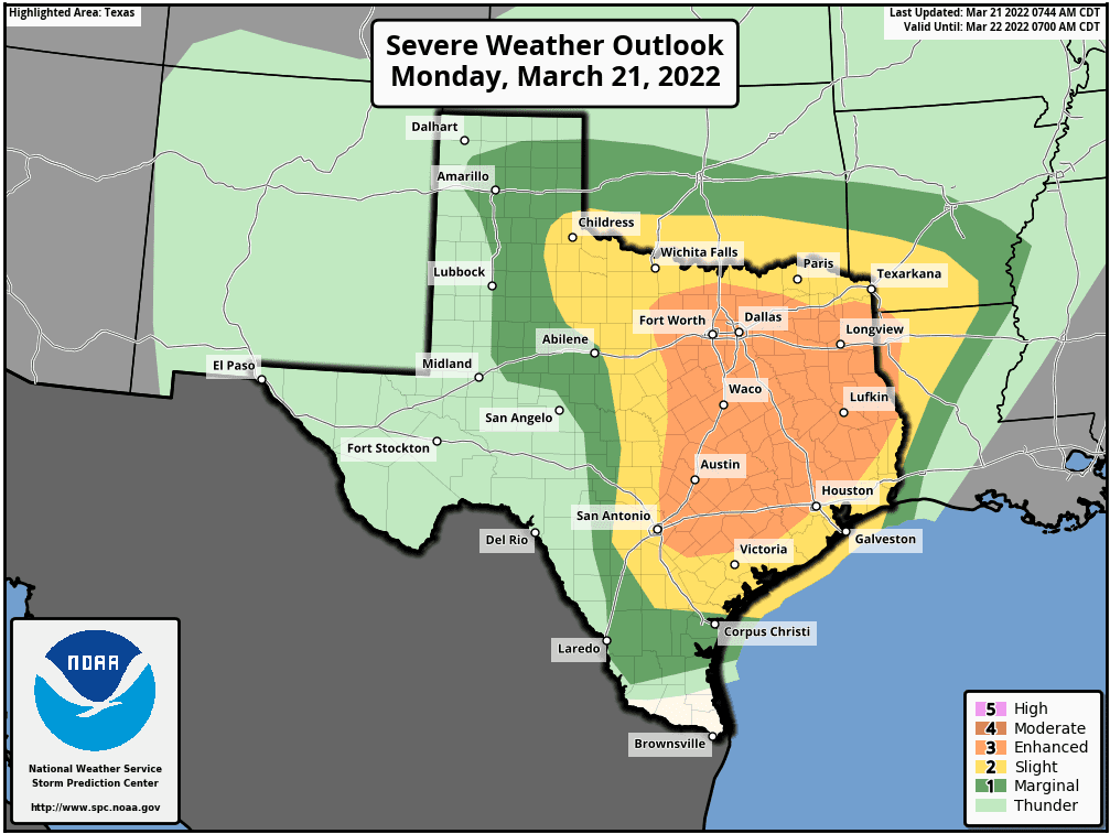
High-resolution forecasts call for an area strong to severe thunderstorms to develop in the vicinity of U.S. Highway 281,from north of San Antonio, to near Burnet, between 1 and 4 pm. The storms are predicted to track to the east, bringing the storms in the Austin/Interstate 35 corridor in the late afternoon, and over the area between Bastrop and La Grange in the early evening.
Large hail greater than 2 inches in diameter, damaging straight line thunderstorm winds in excess of 60 mph and isolated tornadoes will all be possible from today’s storms.
We all need to increase our severe weather awareness for this afternoon into tonight—primarily from mid-afternoon through the evening hours. Please have more than two sources available to receive National Weather Service watches and warnings. Also, I recommend, given the evening rush hour timing of this event, folks adjust their evening drive home to a little earlier or perhaps a little later.
There will be a slight chance for additional rain showers and scattered thunderstorms across the Hill Country and Central Texas regions late this evening and toward midnight when a Pacific cold front sweeps southeast out of Northwest Texas. Here, the chance for rain should diminish before sunrise Tuesday. The rain is forecast to be the heaviest and most persistent this evening and overnight across the coastal plains region, in a zone of enhanced moisture. The rain here is forecast to diminish shortly after sunrise Tuesday.
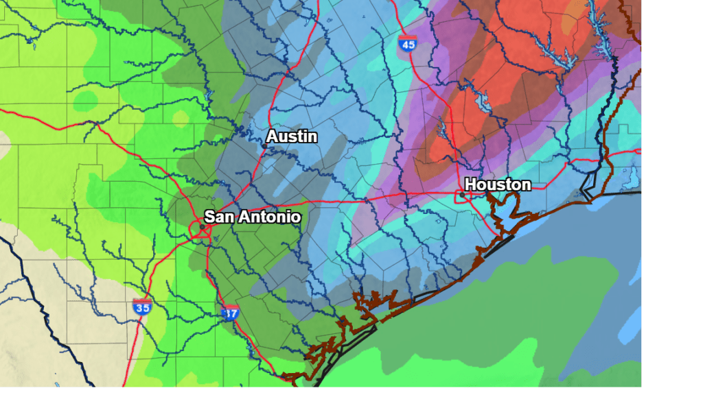
Rain amounts from this afternoon and tonight’s storms are forecast to be lowest across the western Hill Country, and highest across the coastal plains. Out across the western and central Hill Country, totals are predicted to average less than a tenth of an inch. Totals of 0.25 to 0.5 inches are forecast for the eastern Hill Country. For the Austin/Central Texas region and the middle Texas coast, totals are forecast to generally average between 0.5 and 1 inch. Isolated totals of 2-3 inches will be possible across the coastal plains.
NWS Rainfall Forecast for the Period 7 am Monday through 7 am Wednesday:
Sunny, breezy and cooler weather will follow Tuesday and Wednesday. Expect northwesterly winds of 15-25 mph, with gusts to 30 mph Tuesday, and speeds of 10-20 mph Wednesday. High temperatures both days are forecast to be in the upper 60s. Lows Wednesday and Thursday mornings will be in the low 40s.
Bob
Social Media