This week’s weather certainly hasn’t felt like mid-December, with high temperatures near 80 degrees and low temperatures around 68-70 degrees. Daily averages have been running more than 20 degrees above normal! But change is on the horizon as a weekend cold front is expected to bring our region a shot of rain and a blast of cooler air. Unfortunately, warm temperatures are forecast to make a return in advance of Christmas.
Friday’s weather maps showed Central and South Texas under the influence of warm and sticky breezes originating off the Gulf of Mexico. It’s shaping up to be another day warm day, with temperatures expected to peak close to 80 degrees. Satellite images show considerable clouds spreading northeast from the eastern Pacific as well as the Gulf of Mexico. These clouds will keep today’s sky mostly cloudy to occasionally partly cloudy. Gusty southerly winds of 10-20 mph are forecast this afternoon into tonight.
All eyes are on a Canadian cold front that was located across the Southwestern and Central U.S. Friday morning. A large trough of low pressure pushing east across the northern and central Rockies is expected to move the cold south through Texas Friday night into Saturday morning. Forecasts call for the front to reach the northern Hill Country a little after midnight, the Austin area just after daybreak Saturday, and the La Grange area in the late morning. The front is predicted to move off the middle Texas coast mid-afternoon Saturday. Atmospheric conditions appear favorable for a solid area of rain showers and scattered thunderstorms to develop along and behind the cold front as it presses south through our region. Overall, the setup doesn’t appear to be very favorable for the development of severe thunderstorms. However, the Storm Prediction Center has placed the Hill Country the Austin/Central Texas region and the middle Texas coast under a Marginal Risk (a 1 out of 5 risk) for severe thunderstorms. The risk period ends daybreak Saturday for the Hill Country, but continues Saturday morning into Saturday afternoon for the rest of the region. If severe storms happen to develop, the primary severe weather threats will be large hail and damaging downburst winds.
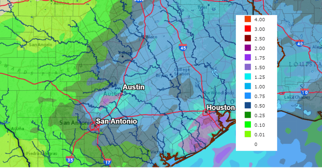
Moderate rain is forecast behind the front, with the rain tapering off from west to east Saturday morning through late Saturday afternoon. Rain totals through Saturday evening are forecast to generally average around 1-1.25 inches across the eastern Hill Country, Central Texas and coastal regions. Totals of 0.25 to 0.5 inches are forecast across the western and northern Hill Country.
NWS Rainfall Forecast for the Period 6 pm Friday through 6 pm Saturday:
Sharply colder and windy conditions will follow Saturday’s cold front with temperatures quickly falling into the 50s. Expect a strong north wind with speeds of 15-20 mph and gusts to 35 mph through Saturday evening. A partly to mostly cloudy sky is forecast Saturday night. Lows Sunday morning will range from the low and mid-30s across the Hill Country to the upper 30s across Central Texas, to the low and mid-40s across the coastal plains.
A chance for light rain showers is predicted to develop across the entire region Sunday afternoon, continuing till about sunrise Monday as a weak wave of low pressure tracks across Texas out of northern Mexico. The probability for rain will be near 20-30 percent Sunday afternoon, increasing to 40 percent Sunday night into early Monday. Rain amounts through Monday morning are predicted to average less than a quarter inch.
- High temperatures Sunday will range from the upper 40s west, to the mid-50s near the coast.
- Low temperatures Monday morning will again include the low and mid-30s across the Hill Country , the upper 30s across Central Texas and the low 40s across the coastal plains region.
A sunny sky is predicted to return Monday afternoon as the wave of low pressure moves off to the east. High temperatures Monday will generally be near 58-60 degrees. Lows Tuesday morning are forecast to be in the mid and upper 30s across the Hill Country and Central Texas regions and near 40 degrees towards the coast.
For next Tuesday through Friday, mostly sunny and dry weather is forecast as our region comes under the influence of a stable ridge of high pressure located over the Southwestern U.S. A warming trend is expected as southerly breezes return.
- High temperatures are predicted to be in the low 60s Tuesday, warming to the upper 60s Wednesday, and the low to mid-70s next Thursday and Friday.
- Low temperatures will be in the upper 30s Wednesday morning, warming to the upper 40s Thursday morning, and into the 50s Friday and Saturday morning.
The outlook for Christmas Day and next Sunday calls for mostly sunny and mild weather. Expect high temperatures in the low 70s, with lows in the 50s.
Looking out into the week after Christmas, the mild and dry pattern looks to continue, with highs in the 70s and lows in the 50s.
The Line of Planets Continues in the Evening Sky
The Jupiter-Saturn-Venus line of planets at dusk continues to slowly evolve. Saturn is now a little closer to Venus; a month ago it was closer to Jupiter. And the whole line is sliding farther to the lower right.
But the line is now growing longer again, not shorter. If you were hoping Jupiter was on its way to a conjunction with Venus, it is not. Venus is now diving away back down toward the Sun (it passes the Sun in daytime on January 8th). As for Jupiter and Saturn, their own next conjunction doesn’t come until November 2, 2040.
The December full moon will occur Saturday night at 10:36 pm CST. However, the moon will appear full Friday and Sunday nights as well. Saturday evening, the full moon will meet the line of 3 planets across the evening sky.
Have a good weekend.
Bob
Social Media