Rain showers and isolated thunderstorms spread across the Hill Country and Central Texas over the weekend in advance of a Pacific cold front. The rain tapered off from west to east Sunday afternoon. According to LCRA’s Hydromet, the highest rain totals occurred across northern Hill Country, between Abilene and Brownwood, where a few locations received between 1 and 1.25 inches. Totals to near three quarters of an inch were noted between Brady, Menard and Sonora. Elsewhere, most totals averaged between a tenth and a third of an inch. Drier and slightly cooler air behind the front allowed Monday morning’s temperatures to fall into the 30s and 40s across the Hill Country and Central Texas. Towards the coast, low temperatures were generally in the 50s to near 60 degrees.
Sunday’s cold front stalled just off the middle and upper Texas coast Sunday night. Shallow moisture near and just behind the front resulted in the development of widespread and persistent fog across the coastal plains Monday morning. The fog is forecast to slowly lift midday and through the early afternoon. Once the fog lifts, the sky is expected to remain mostly cloudy through late afternoon. A couple of spotty light rain showers will be possible. For the Hill Country and Central Texas regions, this afternoon’s weather will be sunny and breezy. Temperatures are forecast to warm into the low and mid-80s across the entire region. Expect south and southwesterly breezes at 10-15 mph, with occasional gusts to 25 mph.
The stalled front along the coast is predicted to lift back to the north as a warm front Monday night into Tuesday morning. This will bring a return of warmer and more humid air. The sky looks to become cloudy by midnight. Patchy fog will be possible across parts of Central Texas and the middle Texas coast. Lows Tuesday morning will generally be in the low and mid-50s, with mid-60s expected towards the coast.
Tuesday will start off with widespread clouds and patchy fog. The sky should become partly to mostly cloudy in the afternoon. Winds will pick up to around 10-15 mph in the afternoon. High temperatures will generally be in the low 80s.
Forecasts call for a slight chance for rain showers and isolated thunderstorms Tuesday evening, with an increasing chance for showers and thunderstorms occurring after midnight. A trough of low pressure currently located along the West Coast is forecast to dip southeast to a position over New Mexico Tuesday night, then lift northeast into the southern Plains on Wednesday. The trough will help drag a Pacific cold front across the state Tuesday night into Wednesday morning. Forecast solutions indicate some similarity in the atmospheric setup with what occurred Saturday night into Sunday morning. Showers and thunderstorms are forecast to develop along and just behind the cold front, with the activity ending from west to east Wednesday morning. Sunshine should develop Wednesday afternoon. Wednesday’s temperature is predicted to warm to the mid-70s.
Rainfall forecasts call for most totals to average between a quarter and a half inch, with some isolated totals to near 1 inch possible.
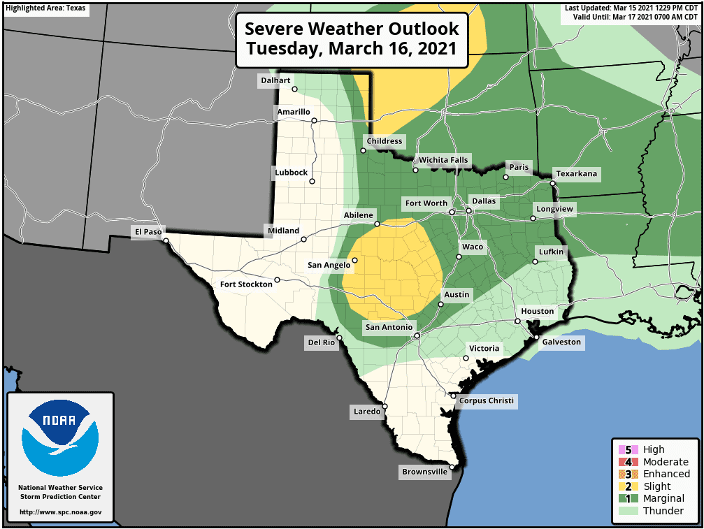
Do note some of the thunderstorms moving across the Hill Country and close to Interstate 35 corridor could be severe. The Storm Prediction Center has placed this area under a Slight Risk (2 out of 5 risk) for severe thunderstorms. The primary severe threat appears to be large hail. The severe weather threat is considerably less for most of Central Texas and the middle Texas coast.
Sunny weather is forecast Thursday, Friday and through the upcoming weekend as a weak ridge of high pressure sets up over Texas and the Southwestern U.S. Daytime temperatures will be mild, but with drier air in place, nighttime temperatures will be cool. High temperatures Thursday and Friday are forecast to be around 70 degrees, warming to the low 70s over the weekend. Low temperatures Friday, Saturday and Sunday mornings will range from the low 40s across the Hill Country to the upper 40s near the coast.
The outlook for next week calls for a somewhat unsettled pattern. Another large trough of low pressure along the West Coast is forecast to dig south into northern Mexico early next week. The trough is predicted to push east across Texas Tuesday into early Thursday, and is expected to cause the widespread development of showers and thunderstorms. Some strong storms will be possible. Forecast solutions are showing a better potential for significant rain with this system, compared to the one this week. Solutions currently call for totals of at least an inch and possibly higher. We’ll have to see how this system evolves over the coming week. Dry and mild weather is forecast late next week. Temperatures look to stay mild throughout the week, with highs in the 70s and lows in the 50s.
Beware the Ides of March? Why?
The Ides of March are today, March 15th. We in modern times probably wouldn’t know about them – or know we’re supposed to beware of them – if it weren’t for William Shakespeare. But why? In ancient Rome, the Ides of March were equivalent to our March 15th. In the Roman calendar, this date corresponded to several religious observances. The Romans also considered the Ides of March as a deadline for settling debts. But – for our modern world – if you’ve heard of the Ides of March, it’s probably thanks to William Shakespeare. In his play Julius Caesar, a soothsayer attracts Caesar’s attention and tells him to beware of the ides of March. Two acts later, Caesar was assassinated on the steps of the Senate. In the play – and in reality – Julius Caesar was indeed assassinated on the ides of March – March 15 – in the year 44 B.C. (courtesy EarthySky.org)
Vernal Equinox Occurs Saturday
At 4:37 am CDT on Saturday, March 20th, the Sun will cross the celestial equator towards the north. This moment will mark the Northern Hemisphere’s spring equinox and the first day of astronomical spring.
Have a good week.
Bob
Social Media