Following a nearly picture-perfect weekend, clouds and moisture made a quick return off the Gulf of Mexico Sunday night. The sky is forecast to remain cloudy to mostly cloudy across the Hill Country and Central Texas regions this afternoon and tonight. There will be a slight chance for a few spotty rain showers, but no significant rain is expected. The sky will be partly cloudy sky the coastal plains region this afternoon, turning cloudy overnight. Today’s high temperature will range from the lower 60s across the northern Hill Country to the upper 60s across Central Texas to the low and mid-70s near the coast. Lows Tuesday morning will be in the 50s.
Tuesday’s weather will feature a mostly cloudy sky as moisture continues to stream inland ahead of a large trough of low pressure located over the Desert Southwest and northwestern Mexico. There will be a 20-30 percent chance for some scattered light rain showers throughout the day across the region, but rain amounts should total less than a tenth of an inch. Southeasterly breezes will increase to 10-15 mph in the afternoon. Occasional gusts to 30 mph will be possible. High temperatures will be in the upper 60s to low 70s. Lows Wednesday morning will be in the low 60s.
A very active period of weather is forecast to take place Wednesday into Thursday as the upper trough over the southwest tracks east across Texas. In advance of the trough, a strong Canadian cold front is predicted to sink south across our region Wednesday morning into Wednesday afternoon. Increasing atmospheric moisture and a favorable thermodynamic profile in the atmosphere will lead to an increasing chance for rain and thunderstorms across the Hill Country Wednesday morning, with the activity spreading east across Central Texas and the coastal plains region in the afternoon. Some of the storms may be strong to severe for areas along and east of Interstate 35 Wednesday afternoon. The primary severe weather threats will be large hail and damaging downburst winds. The Storm Prediction Center has placed the Interstate 35 corridor and areas to the east under a Marginal Risk (1 out of 5 risk) for severe thunderstorms through Wednesday evening.
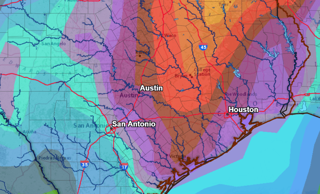
Moderate to occasionally heavy rain will be possible along and behind the cold front Wednesday morning and Wednesday afternoon. Rainfall intensity should decrease from west to east late Wednesday afternoon into Wednesday evening. Rainfall amounts over this period are forecast to average between 0.5 and 1 inch across the western and central Hill Country. For the eastern Hill Country, Central Texas and the middle Texas coast, totals are forecast to average between 1 and 2 inches. Some isolated heavier totals will be possible for the coastal plains region.
NWS Rainfall Forecast for the Period 7 am Monday through 7 am Saturday:
The temperature will turn colder Wednesday afternoon as the cold front pushes southeast across the region. Readings in the 60s Wednesday morning will fall into the 50s and 40s during the afternoon.
A Threat of Snow for the Hill Country and the Interstate 35 Corridor Wednesday night into Thursday Afternoon
Forecasts call for the upper trough to remain to over northern Mexico and southern New Mexico late Wednesday into Thursday. The trough is not expected to push east of our region until Thursday night. With the cold front to our south, a pattern of overrunning light precipitation is forecast to set up across the region. The latest forecasts indicate the atmosphere will be cold enough for the development of a rain/snow mixture across parts of the Hill Country and possibly as far east as the Interstate 35 corridor, including Austin Wednesday night through Thursday afternoon. At the surface, the temperature is predicted to stay above freezing, so little to no accumulation is expected. It is too early to tell if there will be any impacts to roads or travel, especially along and west of Interstate 35. Overall, the confidence for snow is low at this time.
And with temperatures stay above freezing, no ice is expected. Lows Thursday morning will be in the low 30s across the Hill Country, the mid-30s across Central Texas and the low 40s towards the coast. High temperatures Thursday will be mainly in the low to mid-40s and be near 50 degrees towards the coast.
The precipitation is forecast to end from west to east late Thursday afternoon, with the sky clearing Thursday evening. A freeze is forecast at most locations Friday morning. Lows Friday morning will include the low and mid-20s Hill Country, the upper 20s to 30 degrees Central Texas and the lower 30s coastal plains. New Year’s Day weather will be sunny and cool with high temperatures in the low and mid-50s.
Sunny, dry and cool weather is forecast Saturday and Sunday. Lows Saturday morning will be near or below freezing. Lows Sunday morning will be mostly in the 30s. High temperatures will be in the 50s Saturday, warming to the low 60s Sunday.
The outlook for next week calls for the weather to stay sunny and dry. High temperatures will be in the 60s with lows in the 40s.
Bob
Social Media