The combination of a stalled cold front and an unusually moist air mass caused the development of persistent and heavy rains across Southeast Texas, including the middle Texas coast, late Thursday night through Friday morning. According to LCRA’s Hydromet, totals of 3-4 inches fell over the area between La Grange and Bay City.
Friday’s weather maps showed a stalled area of low pressure located over northern Mexico and a stationary front stretching from Tyler, to La Grange to Rockport. With a very moist and unstable air mass in place along and east of the front, the atmospheric setup across the coastal plains became quite favorable for the development of rain showers and thunderstorms. As of mid-afternoon, the heavy rain over the coastal region had weakened. However, additional showers and thunderstorms are forecast to develop across the region this evening and overnight as a wave of low pressure rotates north out of Mexico. The rain is expected to be moderate to occasionally heavy in intensity. Additional totals of 1-2 inches is forecast through early Saturday morning. Due to the high risk for flash flooding, the National Weather Service has posted a Flash Flood Watch for the coastal region and all of Central Texas, plus the Hill Country counties of Bandera, Kendall, Kerr, Gillespie and Blanco through Saturday night.
Saturday’s weather is shaping up to be wet and quite active across the entire region. The area of low pressure parked over northern Mexico is forecast to begin tracking to the east across Texas. A large area of rain showers and thunderstorms is predicted to develop across West Texas and the Edwards Plateau early Saturday morning. The area of rain and storms is forecast to slowly spread east across the Hill Country, Central Texas and coastal areas Saturday through Saturday evening. Out ahead of this area of rain, showers and thunderstorms are forecast to continue over parts of Central Texas and the coastal plains. Forecasts call for the rain to taper off across the Hill country and Central Texas regions Saturday evening through Saturday night. Across the coastal plains, the rain is predicted to end before noon on Sunday.
Some of the storms on Saturday may be strong to severe across the region. The Strom Prediction Center has placed the Hill Country, Central Texas and the middle Texas coast under a Marginal Risk (a 1 out of 5 risk) for severe thunderstorms. It’s quite possible the threat for severe storms will be increased by WPC forecasters on Saturday. Large hail, damaging winds and even a few isolated tornadoes will all be possible.
Widespread moderate to occasionally heavy rain is forecast across the region Saturday into Saturday evening. Additional totals of 1-3 inches, with isolated heavier totals, are forecast across the Hill Country , Central Texas and coastal regions.
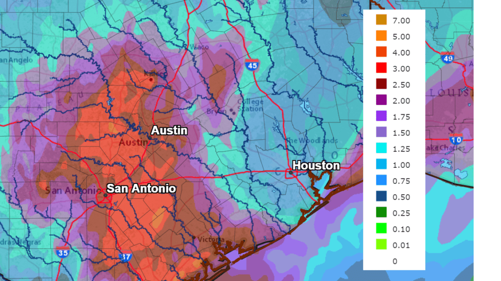
NWS Rainfall Forecast for the Period 7 pm Friday through 7 pm Sunday:
As the upper low exits the area, sunny and warmer weather is forecast to develop Sunday afternoon and persist through Monday. High temperatures are forecast to be in the mid-80s Sunday, warming to the low 90s on Monday.
Scattered rain showers and a few thunderstorms are expected to develop over area areas along and east of Interstate 35 Monday night through Tuesday afternoon. Forecasts call for a weak trough of low pressure and a weak cold front to move across the area at that time. As of now, rain amounts are forecast to average between a quarter and a half inch.
In the wake of this system, sunny and dry weather is forecast Wednesday, continuing through next weekend. High temperatures are forecast to be mostly in the low 80s, with low temperatures in the low 60s.
Have a good weekend.
Bob
Social Media