A strong trough of low pressure currently digging into northern Mexico is forecast to slowly push east across Texas Wednesday and Thursday, producing a variety of weather from heavy rains and possible severe weather over Southeast Texas, to snow over the Texas Hill Country and much of West Texas. Considerable moisture is spreading north from the Gulf in advance of the trough, setting the stage for an active period of weather.
This afternoon’s weather will feature a mostly cloudy sky along with breezy south winds at 10-15 mph. A few spotty light rain showers will be possible, but rain amounts should average less than a tenth of an inch.
A cold front currently located across New Mexico is forecast to push east/southeast this afternoon and tonight, reaching the western Hill Country Wednesday morning. The front is predicted to reach the Austin area in the early to mid-afternoon and the La Grange/Columbus area by evening. Rain showers and scattered thunderstorms are forecast to develop across the region out ahead of and along the cold front Wednesday morning and continue through Wednesday afternoon and evening. The Storm Prediction Center has placed the Austin/San Antonio area and locations to the southeast under a Marginal Risk (1 out of 5 risk) for severe thunderstorms on Wednesday. Large hail and damaging winds will be the primary severe weather threats. The threat for severe storms will decrease late Wednesday afternoon and evening as cooler air spreads in behind the cold front.
Widespread moderate to occasionally heavy rain is forecast across the region Wednesday, continuing through Wednesday night. The precipitation is expected to trend lighter across the Hill Country and Central Texas regions after midnight Wednesday night. A widespread coverage of mostly light precipitation is forecast across the region Thursday, with the precipitation diminishing Thursday evening.
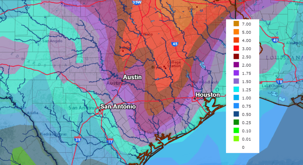
Rain between Tuesday afternoon and Friday morning is forecast to generally total between 1 and 1.5 inches across the western and central Hill Country while totaling between 2 and 3 inches across the eastern Hill Country, Central Texas and the middle Texas coast. Isolated totals of 3-5 inches can be expected across the coastal area.
NWS Rainfall Forecast for the Period 6 pm Tuesday through 6 pm Friday:
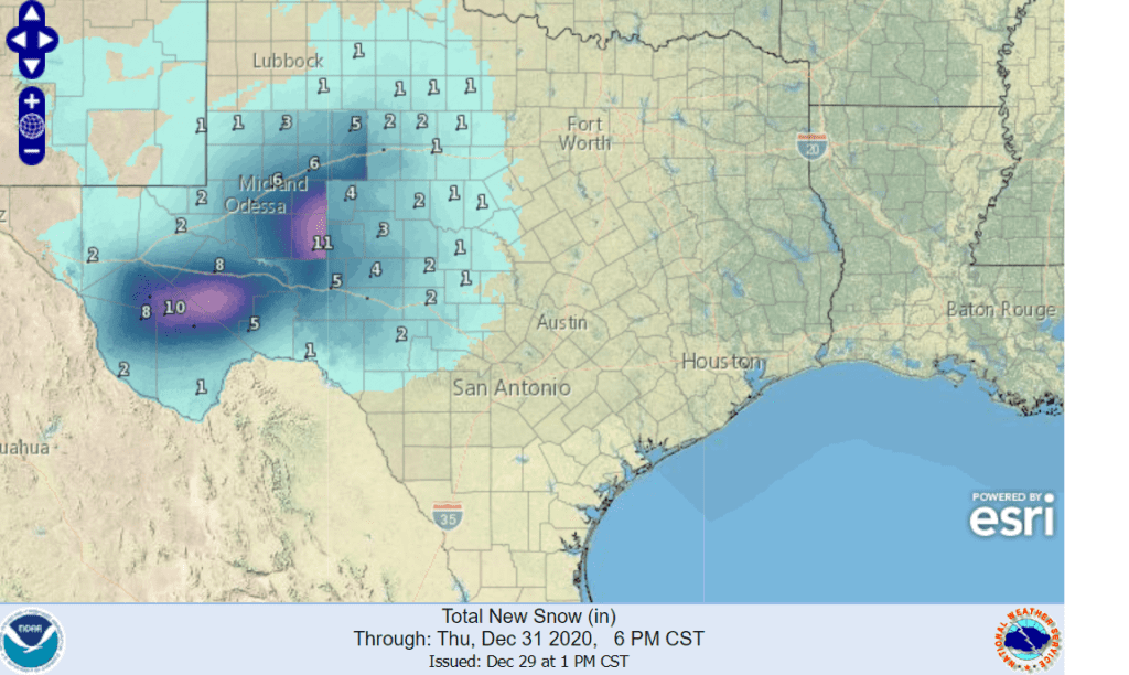
The eventual track of the upper trough over Mexico will be critical to where mixed precipitation and snow develops. The latest forecasts call for the trough to move across the southern half of the Hill Country and Central Texas during the day on Thursday. As the trough pushes east, the atmosphere over much of the Hill Country is forecast to cool sufficiently to allow for the light rain to become mixed with light snow and sleet beginning early Thursday morning. Forecasts call for accumulating snow to develop across the western and northern Hill Country during the day Thursday, mainly to the west of a line stretching from San Saba to Rocksprings. Here, totals of 1-3 inches and possibly higher are forecast. Mainly a light dusting of snow with accumulations to near 1 inch is forecast across the eastern Hill Country.
The following National Weather Service snowfall forecast shows the highest snow totals to occur to the west of San Angelo and also across the mountains of Far West Texas
For the Austin area and the Interstate 35 corridor, forecasts now indicate the atmosphere will be too warm for measurable snow to develop and make it to the ground. While a few flakes of snow cannot be ruled out, most of Thursday’s precipitation is expected to be just a cold rain. High temperatures Thursday will range from upper 30s across the Hill Country to the upper 40s towards the coast.
All of the precipitation is expected to come to an end Thursday evening, with the sky clearing by Friday morning. A light freeze is forecast across the Hill Country and Central Texas regions Friday morning. Lows will be near 28-30 degrees across the Hill Country, the lower 30s across Central Texas and the mid to upper 30s near the coast.
Sunny and cool weather looks to continue Saturday and Sunday.
Bob
Social Media