We’re now about two-thirds the way through meteorological summer and the “Dog Days” continue to have a hard time setting up across our area. Earlier this week, it appeared we were about to settle into a long stretch of hot and dry weather. But over the past couple of days, the forecast began to change, taking note of an unusual early-August cold front that is forecast to push into the area early next week. The front will be arriving at what is typically the hottest point of summer for most of Central and South Texas. Clouds and scattered showers next week are predicted to keep our high temperatures mostly in the low to mid-90s, rather than the 98-100 degree readings more typical for the first week of August. In addition to the lower temperatures, rain accumulations to around an inch or so will be possible. Warmer temperatures do look to return next weekend, but widespread triple-digit temperatures are not forecast as the center of the summertime heat dome is expected to remain to the west of Texas.
Friday’s weather maps showed a sprawling ridge of high pressure, or heat dome, stretching from the Pacific Northwest, southeast to Florida and Cuba. The heat dome was centered over northern Oklahoma and southern Kansas. A clockwise wind flow around the periphery of the ridge is steering a moist flow from the Gulf of Mexico into South and Central Texas. On Thursday, the combination of tropical moisture and a slightly unstable atmosphere caused the development of scattered afternoon rain showers and thunderstorms across the region. A similar setup is forecast to be in place this afternoon, Saturday and Sunday, with moisture spreading inland off the Gulf leading to a slight chance for scattered showers and thunderstorms. The chance for rain at any given location will be 20 percent. Developing thunderstorms will be capable of producing gusty winds of 40-50 mph. And while most rain amounts should average less than a quarter inch, a couple of locally heavy downpours with totals to 1.5 inches, will be possible.
Aside from the slight chance for rain, weather conditions this afternoon, Saturday and Sunday are shaping up to be mostly sunny and hot. High temperatures each day are forecast to be in the mid to upper 90s. High humidity levels will cause peak heat indices to be near 105-108 degrees.
The much talked about cold front is predicted slide slowly south of the Red River late Sunday night and spread across North Texas on Monday. The front is forecast to move into the Hill Country and Central regions Tuesday and pull up stationary. Showers and thunderstorms developing along the front are forecast to spread south into the Hill Country, Central Texas and coastal regions Monday afternoon and Monday night. The probability for rain will be near 50-60 percent across the Hill Country and Central Texas regions and near 30 percent towards the coast. Rain amounts are forecast to generally average between 0.25 and 0.5 inches, with isolated totals to 1 inch possible. High temperatures Monday will be in the mid-90s.
Tuesday through Thursday, forecasts call for a partly to mostly cloudy sky across the region. High temperatures are predicted to be in the low 90s. There will be a 40-50 percent chance for scattered rain showers through the period as the front remains stalled across the area. Daily rain amounts are forecast to average between 0.25 and 0.5 inches.
A slight chance for rain showers and isolated thunderstorms is forecast next Friday as the stalled front begins moving back to the north. Rain amounts, if any, should total around a tenth of an inch. Expect high temperatures to be in the mid-90s.
Looking out into next weekend and the week of August 9th, forecast solutions call for the heat dome, which had been pushed out the West Coast, to return to the southern Rockies and the central Plains states. For our region, this means mostly sunny and hot weather, with just a few isolated afternoon showers around the region. High temperatures are predicted to be mostly in the mid and upper 90s. Some might say the “Dog Days” might be trying to make a comeback.
Tropical Weather Outlook
Weather conditions remain quiet across the tropical Atlantic, the Caribbean Sea and the Gulf of Mexico.
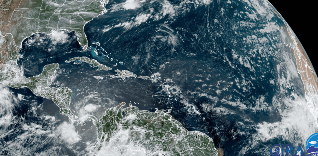
NOAA/Colorado State University/RAMMB 07/30/2021 12:30 pm CDT
There are no features in place which pose a threat for tropical development over the next 5 days.
Get Ready for the Perseids!
The August Perseids are the most beloved meteor shower of the year for the Northern Hemisphere. They’re a rich meteor shower, and they’re steady. And this year is expected to be an excellent year for the shower as the moon will have set long before the show. The 2021 Perseid meteor shower is projected to produce the greatest number of meteors on the mornings of August 11, 12 and 13. Make plans now to scope out a dark spot to enjoy the best meteor shower of the year.
This weekend and all of next week, the International Space Station will be making passes across our Central Texas sky. Friday night’s pass will be low and won’t occur until 11:14 pm. But passes on Saturday and Sunday will be a little higher and a little earlier: 10:27 pm Saturday and 9:40 pm Sunday. More information can be obtained through NASA’s Spot the Station webpage: spotthestation.nasa.gov
Have a good weekend.
Bob
Social Media