The atmosphere across the Hill Country and Central Texas will become favorable for thunderstorm development this afternoon in advance of a trough of low pressure tracking east out of the Desert Southwest. Overnight, moisture surged north from the Gulf of Mexico, resulting in widespread clouds, drizzle and fog. At the same time, a warm front began lifting north from the coastal plains, bringing warmer and more humid air. In short, the atmosphere has become quite moist and is becoming increasingly unstable. Scattered rain showers and a few isolated thunderstorms will be possible across the region from late morning through the late afternoon in this moist and unstable environment. And some of these storms could become strong to severe.
High-resolution forecasts call for an area thunderstorms to develop across the central Hill Country around midday as the dry line pushes east out of West Texas. The area of thunderstorms is forecast track slowly to the east-north and approach the Austin/Interstate 35 corridor by about mid-afternoon. The area of showers and storms is predicted to spread across Central Texas in the late afternoon, reaching the coastal plains this evening. The rain and thunderstorms are expected to push east of the Hill Country and Central Texas regions this evening and clear the coastal plains region before midnight.
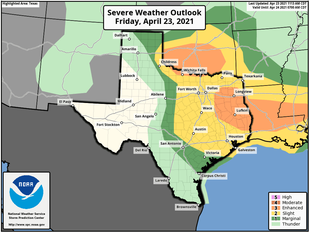
The Storm Prediction Center has placed the central and eastern Hill Country, Central Texas and the middle Texas coast under a Slight Risk (a 2 out of 5 risk) for severe thunderstorms this afternoon and tonight. Large to very large hail and damaging winds are forecast to be the primary severe weather threats, although there will be a low-end threat for a couple of isolated tornadoes. SPC forecasters have highlighted the eastern Hill Country and the I-35 corridor, including the Austin area, for an increased risk for significant hail.
Rainfall forecasts haven’t change appreciably since Thursday. The forecast calls for general totals of a quarter to a half inch across the Hill Country and Central Texas, with totals of 0.75 to 1 inch across the coastal plains. Very isolated totals of 1-2 inches will possible.
A Pacific cold front is forecast spread across the area Friday night into early Saturday morning, bringing drier and more stable air. Sunny, dry and warm weather is forecast across the region Saturday through Monday.
- Lows Saturday morning will range from the mid-50s across the Hill Country to the mid and upper 60s near the coast.
- High temperatures Saturday will range from the upper 70s west, to the mid-80s near the coast.
- Lows Sunday morning will range from the low 50s across the Hill Country to the upper 50s near the coast.
- High temperatures Sunday and Monday will be in the upper 80s.
- Lows Monday morning will be in the low 60s.
Forecast solutions call for another trough of low pressure to sink south into the Desert Southwest early next week. This system is predicted to track across northern Texas late Tuesday into Wednesday and is expected to bring our region another period of rain and thunderstorms. Forecasts call for Gulf moisture to surge north into Texas Tuesday, causing a partly to mostly cloudy sky. Showers and isolated thunderstorms are predicted to develop Tuesday night, with a good chance for rain and thunderstorms expected Wednesday into Wednesday night. There are indications this system could bring our region another threat for severe storms on Wednesday. Forecasts are indicating this system may be a little wetter, compared to today’s storm system. Forecasts call for general totals of 0.5 to 1 inch. These totals could go a bit higher if the system moves slower than currently forecast. The rain is predicted to end from west to east Wednesday night into Thursday morning.
High temperatures Tuesday will be in the upper 80s, falling to the low 80s Wednesday and the upper 70s Thursday. Lows will be in the mid-50s to mid-60s.
Sunny, dry and warm weather looks to develop Thursday and continue through the following weekend. High temperatures will be in the upper 70s Thursday, warming to the mid and upper 80s by the weekend.
Looking out into week of May 3rd, forecasts call for a generally dry and warm week as a ridge of high pressure sets up over Texas. High temperatures will be in the upper 80s to 90 degrees.
GEOMAGNETIC STORM WARNING: NOAA forecasters say that G2-class geomagnetic storms will be possible on Sunday, April 25th when a coronal mass ejection (CME) is expected to hit Earth’s magnetic field. The CME was hurled in our direction yesterday by a C3.8-class flare from sunspot AR2816. If the geomagnetic storm occurs as predicted, auroras could dip into northern-tier US states from Maine to Washington Sunday night.
Have a good weekend.
Bob
Social Media