A summer-like weather pattern is currently in place across the region thanks to a warm, moist wind flow off the Gulf of Mexico. Fortunately, this parting visit from summer will be fairly short-lived, thanks to a cold front arriving sometime late Tuesday night into Wednesday morning. Cooler and drier air is expected for the second half of the week, continuing into the weekend. In fact, after today and Tuesday, no additional 90-degree temperatures are forecast over the next couple of weeks.
The widespread area of low clouds which developed across Central and South Texas Sunday night are forecast to dissipate early this afternoon. This will be followed by a sunny sky and unseasonably warm temperatures, with readings climbing to near 90-92 degrees. The sky will be clear this evening, but widespread low clouds look to develop again after midnight. Lows Tuesday morning will range from the upper 60s across the Hill Country to the low 70s near the coast.
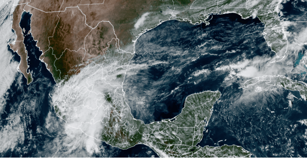
Tuesday’s sky is forecast to remain mostly cloudy throughout the day as a large area of mid and high-level clouds spreads northeast across Texas out of Mexico. These clouds will be associated with the some of the remnants from eastern Pacific Tropical Storm Rick, which made landfall Monday morning along the southern coast of Mexico, northwest of Acapulco. Rick is forecast weaken rapidly this afternoon and tonight as it encounters the mountainous terrain of southern Mexico. A strong southerly flow developing in advance of a large trough of low pressure pushing east out of western U.S. is predicted to pull middle and high-level remnant clouds from Rick northeast across Texas Tuesday into Tuesday night. In addition, there will be a 20 percent chance for a few spotty rain showers and isolated thunderstorms for areas along and east of Interstate 35 Tuesday afternoon. Rain amounts should total less than a tenth of an inch. High temperatures Tuesday are predicated to reach the mid and upper 80s.
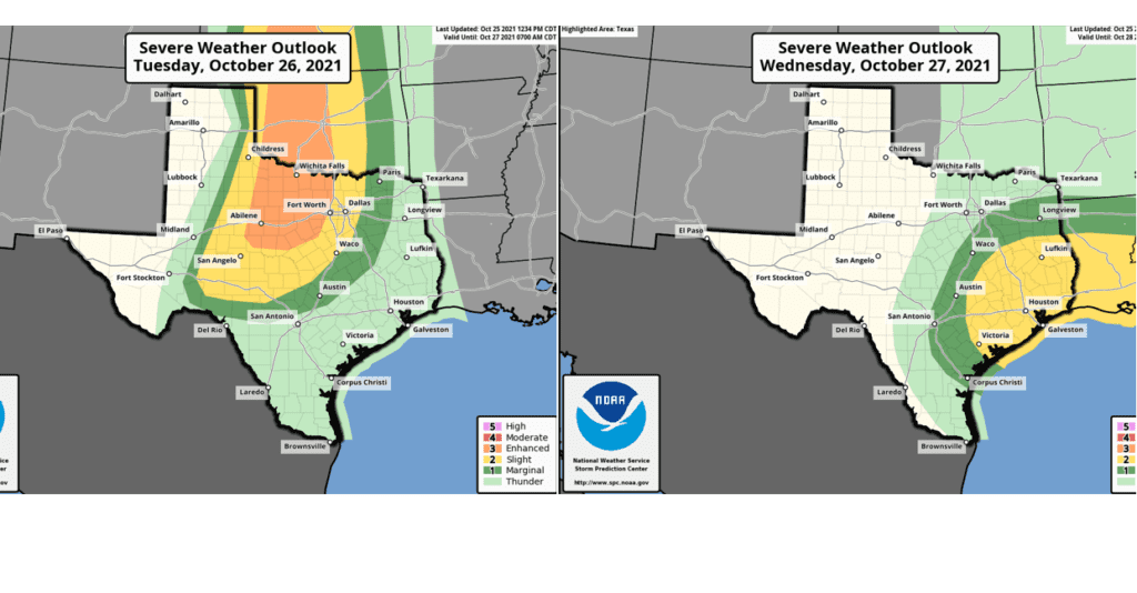
Attention turns to Tuesday night through Wednesday morning when a Pacific cold front associated with the large trough out west pushes east across the state. Ahead of the front, the atmosphere is forecast to become quite moist and fairly unstable. Forecasts call for the development of strong to severe thunderstorms across parts of West Texas Tuesday evening. The rain and storm activity is forecast to expand in coverage and shift east-southeast into the Hill Country and the Interstate 35 corridor after midnight Tuesday night. The highest threat for severe storms is predicted to be across North Texas, extending south to the area between Abilene and Brownwood. The Storm Prediction Center has placed this area under an Enhanced Risk (a 3 out of 5 risk) for severe thunderstorms. SPC has placed the Edwards Plateau and the northern half of the Hill Country under a Slight Risk, (a 2 out of 5 risk) for severe thunderstorms Tuesday night. The Interstate 35 corridor, from just north of San Antonio, through Austin, to near Waco has been placed under a Marginal Risk (a 1 out of 5 risk) for severe thunderstorms Tuesday night.
The threat for strong to severe thunderstorms is forecast to shift east of the Interstate 35 corridor after sunrise Wednesday as the cold front slowly pushes to the east. The Storm Prediction Center has placed the area east of a line stretching from Victoria, to Bastrop to Franklin under a Slight Risk (a 2 out of 5 risk) for severe thunderstorms.
The primary severe weather threats will be large hail, damaging winds and locally heavy downpours.
The rain and storms are forecast to taper off across the Hill Country before sunrise Wednesday. Across Central Texas, the rain should taper off from west to east Wednesday morning. Across the middle Texas coast, the rain should end early Wednesday afternoon.
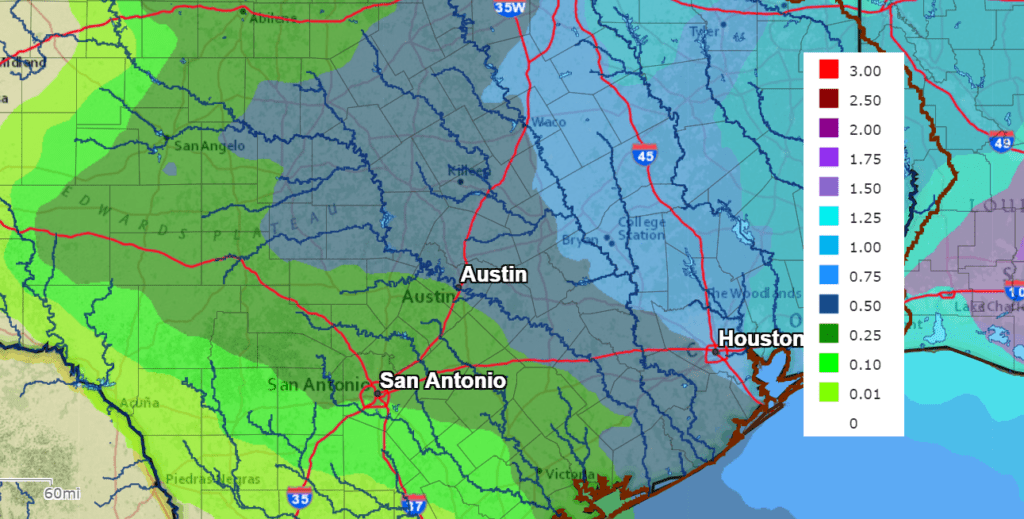
The National Weather Service’s rainfall forecast calls for totals Tuesday into Wednesday to generally average between 0.5 and 1 inch. Somewhat lower totals are forecast for the Edwards Plateau.
NWS Rainfall Forecast for the Period 7pm Monday through 7 pm Wednesday:
Clouds will clear from west to east Wednesday as drier and slightly cooler air spreads in behind the cold front. Expect a northwesterly wind at 15-25 mph to develop Wednesday afternoon. Wednesday’s high temperature will range from the mid-70s Hill Country to the low 80s near the coast. Breezy and cooler weather will follow Wednesday night. Lows Thursday morning will include the low 50s across the Hill Country, the low and mid-50s across Central Texas and the mid-50s towards the coast.
Sunny, breezy and fall-like weather is forecast Thursday and Friday as a dome of Canadian high pressure builds south into Texas. Do note that breezy to windy conditions can be expected both days as a moderate pressure gradient sets up behind the departing storm system. Expect northwesterly winds at 15-25 mph Thursday, decreasing to 10-20 mph on Friday. High temperatures both days will be in the mid and upper 70s. Lows Friday and Saturday mornings will include the mid and upper 40s across the Hill Country, the upper 40s to low 50s across Central Texas and the low 50s across the coastal plains.
Sunny, dry and slightly warmer weather is forecast for the upcoming weekend. Expect high temperatures near 80-82 degrees, with low temperatures in the low and mid-50s. The outlook for the Sunday night trick or treaters calls for clear and cool weather, with temperatures falling through the 60s.
The outlook for next week calls for mostly sunny weather Monday with a high temperature in the low 80s. A cold front is forecast to sweep south across the area Tuesday, possibly causing a few light rain showers. Sunny, dry, and fall-like weather will follow Wednesday through Friday. High temperatures are forecast to be in the 70s, with low temperatures in the 40s to low 50s.
Tropical Weather Outlook
Weather conditions are quiet across the Gulf of Mexico and the Caribbean Sea.
National Hurricane Center forecasters indicate a non-tropical low pressure system is expected to form off the East Coast of the United States by tonight. The frontal low is forecast to move generally north-northeastward through early this week, and the system will likely bring rain and wind impacts to portions of the mid-Atlantic and northeast U.S. coast. The system should then begin to move eastward away from the U.S. coast by midweek. By the end of the week, the low could acquire some tropical or subtropical characteristics while it moves eastward or southeastward over the central Atlantic. NHC forecasters are giving this system a medium chance, a 40 percent chance, for tropical or subtropical development over the next 5 days.
In the eastern tropical Pacific, Tropical Storm Rick moved inland over southern Mexico early Monday morning. As of 1 pm CDT, the center of Rick was located about 105 miles north of Lazaro Cardenas, Mexico. Rick is moving toward the north near 10 mph. A generally northward motion is expected over the next 12 to 24 hours. On the forecast track, the center of Rick will move farther inland over Mexico today and Monday night. Maximum sustained winds have decreased to near 60 mph with higher gusts. Continued weakening is expected this afternoon and evening, and Rick is forecast to dissipate over the mountainous terrain of Mexico Monday night.
NOAA/Colorado State University/RAMMB 10/25/21 2:10 pm CDT
Bob
Social Media