A wet pattern continued over the holiday weekend, with additional rounds of rain showers and thunderstorms pushing south across the region. Some of highest totals of rain occurred across the coastal plains region, where totals of 2-3 inches occurred across parts of Colorado and Wharton Counties. Significant totals also occurred over the Hill Country, generally between Burnet, Llano, and Saba, where totals of 1-1.75 inches were noted. Elsewhere, most totals were considerably lower.
The weather pattern which brought much-needed rain for the past couple of weeks appears to be fading away. In its place, warmer and drier weather conditions are poised to make a quick return. While there will still be a slight chance for scattered rain showers and thunderstorms this afternoon and Wednesday, generally dry conditions are forecast to set up Thursday and persist into next week.
For this afternoon and evening, there will be a 20 percent chance for scattered showers and thunderstorms across the Hill Country and Central Texas regions as a small disturbance tracks south out of North Texas. Rain amounts, if any, should total well below a quarter inch. The chance for scattered showers and thunderstorms will be higher across the coastal plains region, where scattered rains are predicted to spread inland from coast. Here, the probability for rain will be near 40 percent, with totals averaging less than a half inch. Expect a mostly sunny to partly cloudy sky across the area, with high temperatures ranging from the upper 80s near the coast, to the mid-90s across parts of Central Texas.
Another slight chance for scattered rain showers and thunderstorms is forecast for the Hill Country and Central Texas region Wednesday when yet another wave of low pressure tracks south across the state. However, the most favorable area for rain is expected to be to the east of Interstate 35, in a zone of increased moisture. The probability for rain will again be around 20 percent locally, with totals averaging less than a quarter inch. Meanwhile, a better chance for rain will continue across the coastal region, with the probability for rain near 40-50 percent. Totals will generally average around a half inch. High temperatures Wednesday will range from 90 degrees near the coast, to the mid-90s across parts of Central Texas.
Mostly sunny, dry and warm weather is forecast Thursday as an area of low pressure closes off over the lower Mississippi Valley region and a ridge of high pressure begins spreading eastward from the Desert Southwest. With moisture levels decreasing, the chance for rain is expected to diminish. Expect a mostly sunny sky and warm temperatures, with readings generally reaching the low and mid-90s.
Similar weather conditions are forecast Friday, this weekend, and all of next week as the summer heat dome, or ridge of high pressure, begins to once again set up across Texas. No rain is forecast through the period. Expect daily high temperatures mostly in the low and mid-90s, with low temperatures in the low 70s. Long-range forecasts suggest a few showers could return the weekend of September 17th and 18th, but as of now, no significant rain is expected.
In the eastern tropical Pacific, tropical storm Kay developed south of Mexico late Sunday. The system strengthened Monday and became a hurricane Tuesday morning. The center of Kay is expected to pass to the west of the southern Baja California peninsula on Wednesday, and be near the west-central coast of the Baja California peninsula Thursday and Friday. Kay is then forecast to turn west-northwest and weaken off the coast of southern California Friday into Saturday. The moisture and rain associated with Kay is forecast to stay well to the west of Texas through the upcoming weekend.
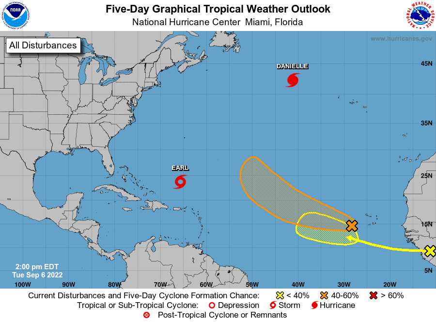
Tropical Weather Outlook
There are no systems in place which pose a threat to the Gulf of Mexico or the Texas coast over the next 5-7 days.
The National Hurricane Center is closely monitoring the progress of Hurricane Danielle located over the north-central Atlantic, to the west of the Azores. Forecasters are also monitoring tropical storm Early. Earl is currently located to the north of the Lesser Antilles and is forecast to pass near or just east of Bermuda late this week.
An area of disorganized showers and thunderstorms continues near the Cabo Verde Islands, extending southwestward several hundred miles. This disturbed weather is associated with a broad area of low pressure located over the area. Environmental conditions are conducive for some development of this system, and a tropical depression could form in a few days while moving westward to west-northwestward at 15 to 20 mph over the eastern and central tropical Atlantic. Upper-level winds are forecast to become less conducive for development late this week. NHC forecasters are giving this system a 60 percent for tropical development over the next 5 days.
Finally, a tropical wave is currently located over western Africa and is forecast to emerge offshore into the eastern Atlantic in a day or two. Environmental conditions appear generally conducive for some slow development of this system as the system moves west-northwestward over the eastern tropical Atlantic. NHC forecasters are giving this system a 20 percent chance for tropical development over the next 5 days.
Have a good, short week.
Bob
Social Media