The wet weather pattern a week ago transitioned directly into a hot and dry summer-like weather pattern early this week. This transition seems to have taken place almost overnight. A ridge of high pressure in the upper atmosphere that had previously been parked over northern Mexico and the Desert Southwest strengthened and quickly expanded east across Texas this week, causing the development of the July-like weather.
Friday’s weather maps showed the large ridge of high pressure covering all of the south central and southwestern U.S., with the ridge being centered between Midland and El Paso. Sinking air underneath the ridge is causing a dry, stable atmosphere along with very hot temperatures. Forecasts call for the ridge to hold nearly stationary through Sunday, then slowly shift west to the central and southern Rockies early next week.
For this afternoon through Sunday, expect a pattern of nighttime and morning low clouds, followed by mostly sunny and hot afternoons. Temperatures each day are predicted to generally reach the mid-90s. But do keep in mind due to the high relative humidity levels, afternoon heat index readings will peak at around 100-105 degrees. There will be a nice southerly breeze at 10-20 mph Friday afternoon and Friday night. But wind speeds are predicted to decrease to around 5-10 mph on Saturday and Sunday.
Monday through Wednesday, little change in the weather is expected across the Hill Country and Central Texas regions as the ridge slowly weakens. Mostly sunny, dry and hot weather will continue, with high temperatures in the mid to lower 90s. Across the middle Texas coast, there will be a 30-40 percent chance for scattered, mainly afternoon showers and thunderstorms each day as a weak cold front sinks into East and Southeast Texas. Some of the showers developing along the front are forecast to spread south and southwest to the middle Texas coast. Daily rain amounts will be low, with most totals around a tenth of an inch or less.
The outlook for late next week calls for partly cloudy and less hot weather as the ridge pulls further away to the west. Expect high temperatures to be close to 90-92 degrees.
Focusing on the Gulf of Mexico Next Week
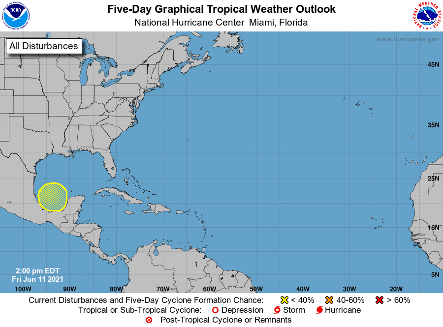
There has been lots of talk recently about the potential for some sort of tropical system to form in the Gulf of Mexico late next week. National Hurricane Center forecasters are now closely monitoring the Bay of Campeche and the southwestern Gulf of Mexico where an area oof low pressure is expected to form early next week. This is the same location where there is a growing consensus among the global forecast model solutions for an area of low pressure to develop early next week. The model solutions call for the system to gradually strengthen as it moves toward the northwest Gulf coast mid and late next week. The low is predicted to reach the coast sometime next Friday or Saturday.
While there is a lot to be worked out on the “when”, “where” and “how organized” this system will be, there continues to be enough consistency in the guidance to signal that something may develop. Regardless of development, a significant surge of tropical moisture toward the middle and upper Texas coast looks possible by the end of next week. This will likely cause an increase in rain chances along with gusty winds.
National Hurricane Center forecasters are currently giving this potential system a 20 percent chance for tropical development over the next five days.
This is definitely something we will want to keep a close eye on over the weekend and early next week.
Elsewhere across the tropical Atlantic, weather conditions are quiet and tropical cyclone development is not expected over the next five days.
Catch a Great Pairing of the Moon and Venus Friday Evening
The bright planet Venus and the thin crescent Moon will form a mystic pair low in the west-northwest sky in twilight Friday evening. The two will be just 2° or 3° apart! Your best view will come about 35 to 45 minutes after sunset, (approximately 9 pm CDT), before the two get too low in the sky.
Venus has now returned to our evening sky. You can catch it every evening, shortly after sunset in the west-northwestern sky. Venus is the third brightest object in our sky, behind the sun and the moon.
Have a good weekend.
Bob
Social Media