Scattered rain showers and thunderstorms spread east across the area Friday and Saturday, bring some very welcome rain to parts of the region. Totals across the Hill Country generally averaged around a half inch, with some isolated totals of 1-2 inches. Across the rest of the region, most totals averaged around a quarter inch, with a few isolated 1-2 inch totals. The weather pattern which allowed for the weekend rain has shifted away from our area and no additional rain is on the horizon for at least the next week.
Some of the hottest temperatures so far this year are predicted to develop this week as a ridge of high pressure and its associated sinking air spreads over Texas out of Mexico. The ridge will cause a very stable atmosphere along with a generally sunny sky. The biggest news this week will be the near-record to record heat. A mass of hot air in the lower atmosphere situated over Mexico is predicted to spread east across Texas, helping surface temperatures to rise into the triple digits across the Hill Country and Central Texas regions. Monday and Tuesday’s temperature looks to be quite hot, with some slight moderation in the temperature expected Wednesday and Thursday.
- High temperatures Monday and Tuesday are forecast to be near 102-105 degrees across the Hill Country, near 100-103 degrees across Central Texas, and in the low to middle 90s across the coastal plains.
- Low temperatures Tuesday and Wednesday morning are forecast to be in the mid-70s across the Hill Country and Central Texas regions, and the upper 70s across the coastal plains.
Due to the forecast for such hot temperatures, the National Weather Service has posted an Excessive Heat Warning for the northern and western Hill Country from 1 pm till 9 pm this Monday. The NWS has posted a Heat Advisory for the central and eastern Hill Country plus the Interstate 35 corridor, including Austin, from 1 pm till 8 pm Monday evening. The very hot temperatures may cause heat illnesses to occur.
Sunny and hot weather is forecast to continue Wednesday and Thursday, although the temperature may moderate down a couple of degrees.
- High temperatures Wednesday and Thursday are forecast to be near 100-102 degrees across the western and northern Hill Country, be near 100 degrees across Central Texas, and in the middle 90s across the coastal plains.
- Low temperatures Thursday and Friday mornings will range from the low 70s across the Hill Country, to the upper 70s across the coastal plains.
Friday through Sunday, sunny and very hot weather will be in place as the ridge strengthens over Texas and the Southwestern U.S. There are some indications a weak cold front will sag south into Central Texas and stall over the weekend. However, the atmosphere is expected to be too dry and stable for the development of any rain.
- High temperatures Friday through Sunday are forecast to be near 103-105 degrees across the northern and western Hill Country, be near 100-103 degrees across the central/eastern Hill Country along with most of Central Texas, and be in the upper 90s across the coastal plains.
- Low temperatures will generally be in the mid-70s.
Looking ahead to next week, little change in the very hot and dry weather is expected as the heat ridge remains parked over Texas and the Southwestern U.S. High temperatures throughout the week are forecast to be around 100-103 degrees across the Hill Country and Central Texas regions, and in the upper 90s across the coastal plains.
Longer-range forecasts suggest this heat wave may very well continue into the week of June 20th.
Tropical Weather Outlook
As of 1 pm CDT, Tropical Storm Alex was located over the west-central Atlantic, about 220 miles northeast of Bermuda. Alex was moving toward the east-northeast near 29 mph and this general motion is expected to continue into Tuesday. Maximum sustained winds have decreased to near 60 mph with higher gusts. Some weakening is forecast, and Alex is expected to become an extratropical low later today.
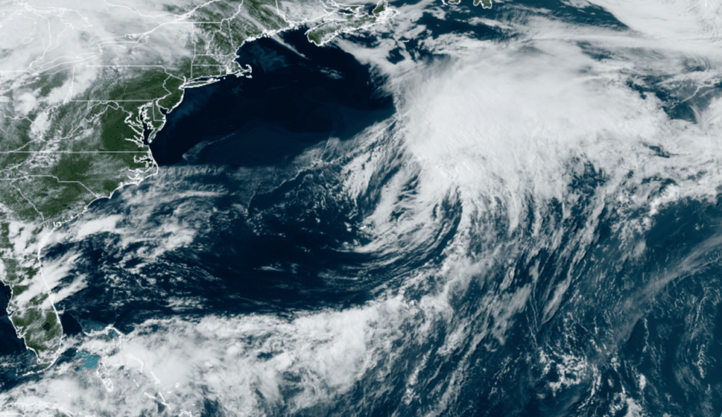
NOAA/Colorado State University/RAMMB 06/06/2022 2:10 pm CDT
Elsewhere across the tropical Atlantic, weather conditions are quiet and tropical cyclone formation is not expected for at least the next 5 days.
Heat Related Precautions/Preparedness Actions
Drink plenty of fluids, stay in an air-conditioned room, stay out of the sun, and check up on relatives and neighbors. Young children and pets should never be left unattended in vehicles under any circumstances.
Take extra precautions if you work or spend time outside. When possible reschedule strenuous activities to early morning or evening. Know the signs and symptoms of heat exhaustion and heat stroke. Wear lightweight and loose fitting clothing when possible. To reduce risk during outdoor work, the Occupational Safety and Health Administration recommends scheduling frequent rest breaks in shaded or air conditioned environments. Anyone overcome by heat should be moved to a cool and shaded location. Heat stroke is an emergency! Call 911.
Bob
Social Media