It’s been a quiet week of weather across Central Texas. Although the days have been warm, the nights have been quite pleasant, with lows in the 50s and 60s. We’ve even seen a break from the humidity. Heading into the weekend, it appears summer-like weather is going to make an appearance as a large ridge of high pressure builds north across Texas this afternoon through Sunday. The ridge will cause more sunny, dry and quiet weather. However, the temperature is expected to trend warmer and relative humidity levels higher as moisture returns off the Gulf.
- High temperatures Friday afternoon will generally be in the low 90s, with upper 80s expected towards the coast.
- High temperatures Saturday and Sunday will generally be in the low and mid-90s, with upper 80s expected towards the coast.
- Low temperatures Saturday morning will be in the mid and upper 60s.
- Lows Sunday morning will be in the upper 60s to low 70s.
Light south breezes at 5-10 mph are forecast this afternoon. Wind speeds look to increase to 10-20 mph Saturday, continuing through Sunday afternoon.
A change in the weather pattern is forecast to take place late Sunday into Monday as the ridge of high pressure over Texas shifts east to the Gulf of Mexico. At the same time, a trough of low pressure lifting northeast out of the Four Corners region will help drag a Pacific cold front east into Texas. The front is forecast push into western Texas Sunday afternoon, then slowly track southeast across the Hill Country late Sunday night. The front is predicted to push about 75 miles east of Interstate 35 Monday morning then pull up stationary. An area of rain showers and scattered thunderstorms is forecast to develop along the front when it tracks across the Hill Country and Central Texas regions Sunday night into Monday morning. The probability for rain will be near 50 percent. The rain is expected to shift away from Central Texas Monday morning, moving to the coastal plains region Monday afternoon. Rain amounts are forecast to generally average less than a third of an inch, with a couple of isolated totals to around 1 inch. Expect a mostly sunny sky across the Hill Country and Central Texas regions Monday afternoon. Towards the coast, the sky will be mostly cloudy.
- High temperatures Monday will be near 88-90 degrees.
- Lows Tuesday morning will be in the low 70s.
Monday’s cold front is forecast to lift back to the north on Tuesday, bringing a quick return of the warm and muggy Gulf air. A few spotty rain showers will be possible Tuesday afternoon. Otherwise, expect a partly cloudy and summer-like day, with high temperatures in the low 90s.
Forecasts indicate a second, stronger trough of low pressure will lift northeast from the Four Corners region Wednesday into Thursday, dragging another cold front into Texas Wednesday into Thursday. In advance of the front, a large area of moisture is forecast to spread north into Texas Wednesday. This will result in a 30-40 percent chance for scattered rain showers and thunderstorms across the region Wednesday afternoon and Wednesday night. The chance for rain and thunderstorms is expected to increase to around 70 percent Thursday when the cold front slowly pushes into the central part of the state and stalls.
The chance for rain and thunderstorms is expected to continue into next Friday as a trough of low pressure tracks southeast out of the northern Rockies and forces a stronger cold front south into Texas. Showers and thunderstorms are expected ahead of and along the front, with the chance for rain diminishing Friday evening.
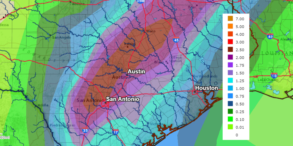
Significant amounts of rain are forecast Wednesday through Friday, with most totals expected to average between 1 and 2 inches. Higher totals will be possible, depending on how these two systems eventually evolve. In addition, forecasters will be closely monitoring the potential development of a tropical cyclone in the eastern Pacific, to the south of Mexico over the next few days. Some high-level moisture from this system could get pulled north into Texas late week, possibly enhancing the rain across the state. Stay tuned for more details on this possibility.
Sunny, dry and cooler weather is forecast next weekend, continuing into the week of October 18th in the wake of next Friday’s cold front. High temperatures are predicted to fall into the 70s to low 80s. Low temperatures are forecast to fall into the 40s and 50s.
Tropical Weather Outlook
Weather conditions have recently turned quiet across the much of the tropical Atlantic. The season is far from over, but no organized storms are ongoing at this time.
National Hurricane Center forecasters are monitoring an area of low pressure system located a couple of hundred miles east of the coast of South Carolina. Satellite images and surface observations Friday afternoon indicated this system is gradually becoming better defined. Although the associated shower and thunderstorm activity is currently disorganized, environmental conditions could briefly become marginally conducive for the low to acquire subtropical characteristics by Saturday night and early Sunday. By early next week, the low is expected to interact with a frontal boundary, which should end the opportunity for any subtropical or tropical formation. The low is forecast to meander offshore the Carolinas today, and then slowly move back toward the west-northwest and northwest on Saturday, bringing the system closer to the coast of North Carolina. Regardless of development, intermittent periods of locally heavy rains and gusty winds will affect eastern portions of the Carolinas through the weekend. An Air Force Reserve reconnaissance aircraft is scheduled to investigate the system Saturday afternoon, if necessary. NHC forecasters are giving this system a medium chance, a 40 percent chance, for development over the next 5 days.
Elsewhere, there are not features in place which pose a threat for tropical cyclone development over the next 5 days.
In the eastern tropical Pacific, NHC forecasters are monitoring a tropical wave located a few hundred miles south of the coasts of Guatemala and southern Mexico. This system is currently producing an area of disorganized showers and thunderstorms. Environmental conditions are forecast to be conducive for development, and a tropical depression or tropical storm is expected to form by late this weekend or early next week while the system moves westward to west-northwestward at about 15 mph south of the coast of Mexico.
NHC forecasters are giving this system a high chance, a 90 percent chance, for tropical development over the next 5 days.
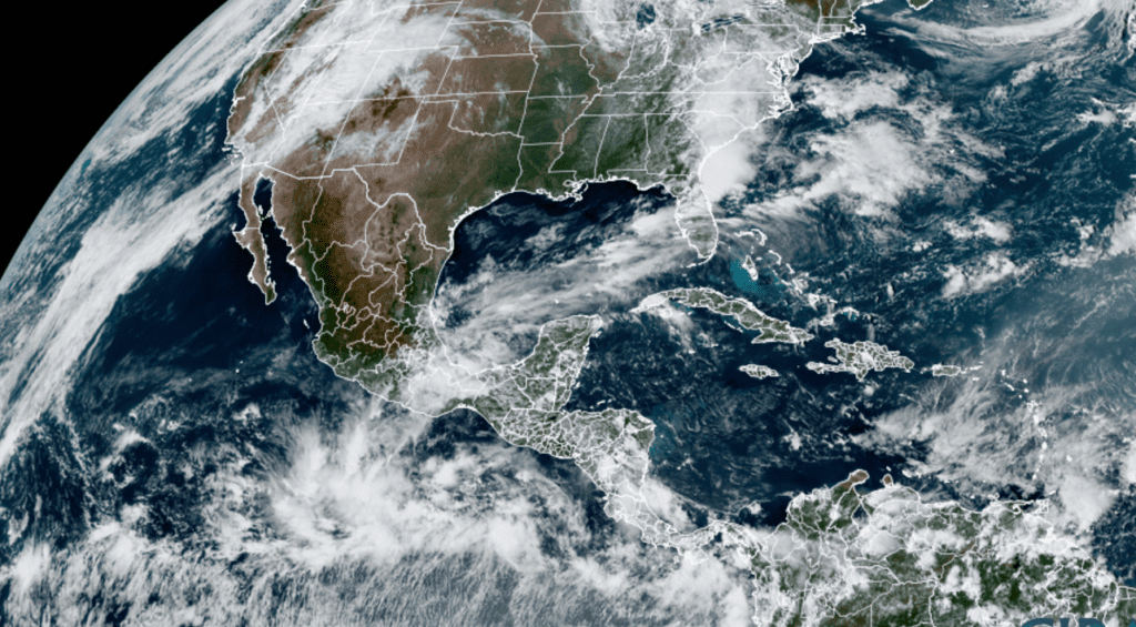
NOAA/Colorado State University/RAMMB 10/08/21 2:00 pm CDT
Catch the Moon and Venus Each Evening this Weekend
Beginning this evening, October 8, a young moon will return to the evening sky just after sunset and it will sweep past the bright planet Venus over the next several evenings. Venus will be just to the left of the thin moon Friday evening. Venus and the moon will be extremely close to each other Saturday evening. By Sunday evening, the moon will be located to the left of Venus.
While you’re checking out the evening sky, don’t miss the planets Jupiter and Saturn shining high in the southern sky shortly after sunset.
Have a good weekend.
Bob
Social Media