Sunday turned out to be the hottest day so far this summer, with the temperature approaching 100 degrees across much of the region. And the heat isn’t done by any means. Overnight, a large complex of showers and thunderstorms developed on the west side of the DFW metroplex and tracked very slowly to the west-southwest. As of noon, the complex of storms was located over the area from west of Abilene to San Angelo and Big Spring. Forecasts call for the complex of storms to spread further into West Texas this afternoon, having no impact on the Hill Country or Central Texas regions.
The huge weather story on this Monday is the forecast for more very hot temperatures across the state and the region. Monday’s weather maps showed an unusually strong ridge of high pressure in the upper atmosphere covering the western and central U.S. The ridge was centered over western New Mexico. Sinking air from the ridge combined with the drying ground is expected to cause very hot afternoon temperatures—very much like what we saw on Sunday. Clouds on the periphery of the West Texas storm complex may help hold down temperatures a few degrees across the western and northern Hill Country. Under a mostly sunny sky, this afternoon’s temperature is forecast to climb to around 98-101 degrees across the eastern half of the Hill Country and all of Central Texas. Across the coastal plains and western Hill Country, high temperatures are forecast to reach the mid-90s. Do note a couple of isolated showers and thunderstorms will be possible across the coastal plains region this afternoon as the Sea Breeze pushes inland from the coast.
Only minor changes in the current pattern are forecast for Tuesday through Friday as the broad ridge of high pressure remains anchored over the western and Central U.S. The ridge is forecast to reach peak intensity mid-week, then shift further west and weaken late week and into the weekend. A slight chance for a few scattered afternoon rain showers and thunderstorms will continue across the coastal plains region, while other locations should remain mostly sunny and dry. Forecasts call for high temperatures each day to generally be in the mid and upper 90s.
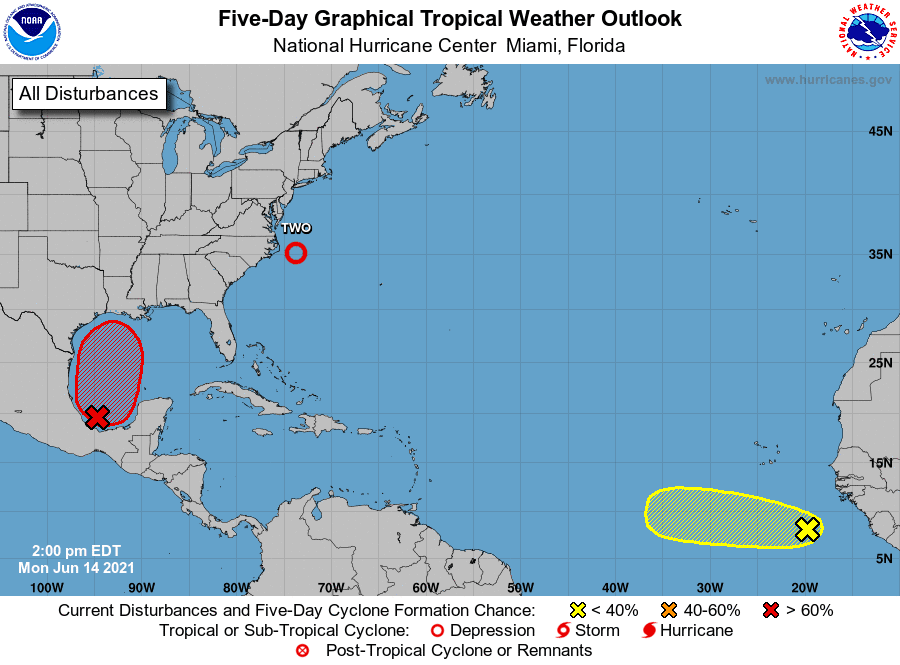
There is some uncertainty in the outlook for Friday and the upcoming weekend hinging on the potential development of a tropical disturbance in the western Gulf of Mexico. National Hurricane Center forecasters are monitoring an area of disorganized showers and thunderstorms located over the Bay of Campeche that are associated with a broad low pressure area. So far, there is no defined surface low pressure system at the surface. NHC forecasters and global model solutions indicate a surface low/tropical depression may develop here over the next couple of days as the system moves slowly northward into the west-central Gulf of Mexico. NHC forecasters are giving this system a 70 percent chance for tropical development over the next 5 days. Global forecast solutions call for the system to generally move toward upper Texas or Louisiana coasts by about Saturday. At this time it appears the majority of the weather and impacts associated with this system should remain east of Southeast Texas, but there is still uncertainty on where the exact center forms and where the system will eventually move inland. A more westward track could bring a better chance for rain and impacts to the middle Texas coast and possibly Central Texas.
Aside from the potential tropical disturbance/tropical depression, forecasts call for the ridge to become much weaker across Texas this weekend as a broad trough of low pressure sets up across the northern and central Plains states. With a weaker ridge overhead, a few spotty rain showers will be possible across the region. The chance for rain will only be 20 percent and rain amounts, if any, will total less than a tenth of an inch. High temperatures should lower to the low and mid-90s.
The outlook for next week calls for mostly sunny weather. There will be a slight chance for showers and thunderstorms Tuesday into Wednesday when a weak cold front sags south into North Texas. Rain amounts, if any should be low. High temperatures are forecast to remain in the low and mid-90s.
Tropical Weather Outlook
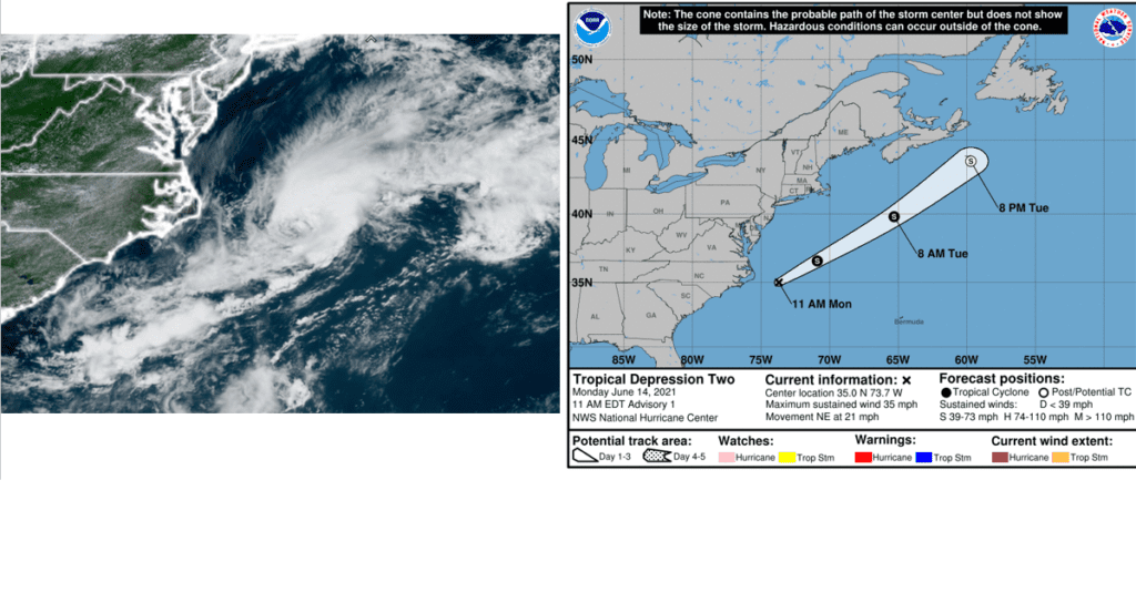
Satellite and radar images show that the low pressure area that NHC forecasters have been following since Sunday off the coast of North Carolina has become better organized with a small central dense overcast over the center and more prominent banding features. As a result, the system has been upgraded to tropical depression Two.
At 10 am CDT, the center of Tropical Depression Two was located about 105 miles east of Cape Hatteras, North Carolina. The depression was moving toward the northeast near 21 mph, and this general motion is expected through Wednesday with increasing forward speed. Maximum sustained winds are near 35 mph with higher gusts. The depression is expected to become a tropical storm by tonight and could continue to strengthen on Tuesday. The system should begin to weaken by Tuesday night and is expected to dissipate on Wednesday as it moves over the waters south of Nova Scotia.
NHC forecasters are also monitoring a strong tropical wave located just offshore of west Africa. The system is producing a large area of disorganized shower and thunderstorm activity. Some development of this system will be possible during the next few days before a combination of dry air aloft and strong upper-level winds limit any chance of formation while the wave is over the central tropical Atlantic Ocean late week. NHC forecasters are giving this system a 20 percent chance for tropical development over the next 5 days.
Bob
Social Media