This past weekend turned out to be the hottest weekend so far this summer. Temperatures Sunday generally reached 100-102 degrees across most of the Hill Country, 98-100 degrees across Central Texas and between 95 and 98 degrees across the coastal plains. For much of the Hill Country, Sunday’s 100-degree readings were the first triple-digit temperatures of the summer. They certainly won’t be the last as numerous triple-digit temperatures are in the forecast over the next 2-3 weeks.
The very hot weekend temperatures developed as a strong ridge of high pressure in the middle and upper atmosphere spread north across Texas out of the western Gulf of Mexico. Monday’s weather maps showed that ridge has merged into a broad ridge of high pressure covering most of the western, Central and Southeastern U.S. This broad ridge, or heat dome, is currently bringing very hot weather to a large part of the nation. Forecasts call for the center of the heat dome to be parked over the southern Rockies today through Wednesday, with the center shifting east to the southern Plains states late week and this coming weekend. The presence of the heat dome is expected to keep our weather generally dry with temperatures quite hot this week, continuing into next week.
This afternoon and Tuesday, expect a sunny sky with hot temperatures. Readings both days are forecast to top out around 98-100 degrees across the Hill Country and Central Texas regions and in the mid-90s across the coastal plains. There will be a slight chance for a few spotty afternoon rain showers across the coastal plains region on Tuesday, but other locations should stay dry.
Wednesday, a slight chance for a few isolated rain showers and thunderstorms is predicted as a weak, non-tropical area of low pressure over the Gulf of Mexico pushes inland over Deep South Texas and northeastern Mexico. This feature is expected to push an area of tropical moisture northward, possibly resulting in the development of a few spotty showers and isolated thunderstorms. For locations that do happen to see rain, totals should only average around a tenth of an inch. High temperatures Wednesday should generally be around 95-97 degrees.
Thursday, Friday and this coming weekend, sunny and hot weather is forecast as the center of the upper ridge moves to the southern Plains. High temperatures Thursday and Friday are forecast to be in the upper 90s across the Hill Country and Central Texas regions and in mid-90s across the coastal plains. High temperatures Saturday and Sunday are forecast to warm a bit to near 98-101 degrees across the Hill Country and Central Texas regions but remain in the mid-90s across the coastal plains region.
The outlook for next week calls for no significant change in the hot and dry pattern as the center of the heat dome remains over the southern Plains states. High temperatures are forecast to be near 99-102 degrees across the Hill Country and Central regions while holding in the mid-90s across the coastal plains region.
Tropical Weather Outlook
Satellite images and radar data indicate that shower and thunderstorm activity associated with a weak low pressure system located a short distance east of the southeastern Georgia coast remains disorganized and limited in coverage. National Hurricane Center forecasters state development of this system is no longer likely before the low moves inland over the Georgia coast later today or tonight. Locally heavy rainfall will be possible over portions of the northeastern Florida and Georgia coasts through tonight.
NHC forecasters are giving this system a low chance (20 percent chance) for development over the next 5 days.
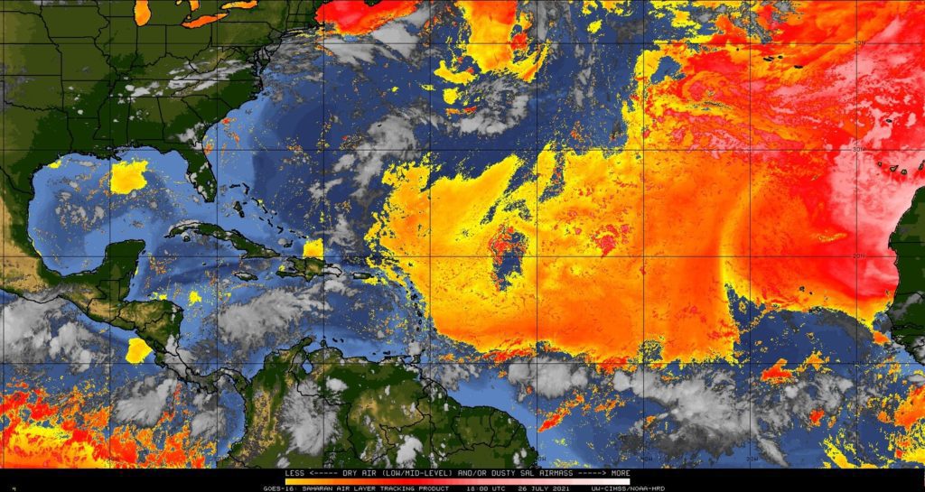
Elsewhere across the tropical Atlantic, weather conditions are quite. Saharan dust levels have decreased across the Caribbean Sea and the Gulf of Mexico but remain high across the eastern half of the Atlantic. Tropical cyclone formation is not expected for at least the next 5 days.
UW-CIMSS/NOAA-HRD
Have a good week.
Bob
Social Media