Two strong cold fronts moving in today and early Monday will finally bring a noticeable change from the late summer weather we have been experiencing for most of October. In addition to the change in temperature behind the fronts, an overrunning pattern next week looks to bring our region the first decent chance for rain in over a month.
As of noon Friday, the cold front was pushing south across the Hill Country and beginning to move into Central Texas. The front stretched from Georgetown to Junction to Fort Stockton. Temperatures behind the front were generally in the 60s and 50s. The front is forecast to make steady progress to the south and southeast this afternoon, moving across Central Texas early to mid-afternoon. The front should reach the Columbus/Interstate 10 corridor mid-afternoon and move off the middle Texas coast shortly after sunset. Ahead of the front, temperatures are forecast to reach the mid-80s across Central Texas and the upper 80s across the coastal plains region. Behind the front, readings should quickly fall into the 60s and 50s. Northerly winds will increase to 10-20 mph, with gusts to 30 mph this afternoon and overnight.
An area of rain showers and thunderstorms developed along the cold front this morning over as it moved over North and Northeast Texas. However, the rain activity has had a hard time developing further west across the Hill Country and Central Texas where the atmosphere is a bit more stable. High-resolution forecasts indicate there will be a slight chance for a few scattered showers and isolated thunderstorms along the cold front when moves across our region this afternoon, but significant rain is not expected. The probability for rain will only be near 20-30 percent and for locations that do see rain, totals should only average around a tenth of an inch. The chance for rain should diminish shortly behind the cold front.
Mostly cloudy, breezy and cooler weather is forecast Friday night. Lows Saturday morning will include the mid and upper 40s across the Hill Country, the upper 40s to low 50s across Central Texas and the mid to upper 50s towards the coast. Saturday will start off with widespread clouds but scattered sunshine is expected by the afternoon. High temperatures are forecast to be around 70-72 degrees. Wind speeds should decrease to around 5-10 mph Saturday afternoon. The sky will be mostly clear Saturday night as light southerly breezes return to the region. Lows Sunday morning should range from the mid-50s across the Hill Country to the low 60s near the coast.
Sunday’s weather will be mostly sunny, breezy and much warmer with high temperatures in the upper 80s. Expect a south wind at 10-15 mph with gusts to 25mph.
Cold front number two is predicted to blast into Northwest Texas Sunday evening. Forecasts call for the front to spread across the Hill Country late Sunday night, reaching the Austin area by daybreak Monday. The front is forecast to continue moving to the southeast Monday morning into Monday afternoon, but it is expected to slow its forward progress and not reach the middle Texas coast until Monday evening. Windy and much cooler weather is expected behind the cold front Sunday night into Monday. Behind the front, northerly winds will increase to 15-25 mph, with gusts to 35 mph. The strong winds are expected to continue Monday night through Tuesday morning.
Forecasts call for a few scattered rain showers to develop along the cold front late Sunday night into Monday. However, a better chance for rain showers is forecast to develop beginning Monday afternoon and continue through Wednesday night when an area of low pressure sinks south to the Desert Southwest, causing a pattern over overrunning clouds and rain across much of Texas. Periods of light rain shows are forecast. Some occasional rumbles of thunder cannot be ruled out. With the recent stretch of warm and dry weather, next week’s rain will be very beneficial. The rainy pattern is forecast to diminish Thursday morning as the stalled trough over the Desert Southwest exits to the northeast.
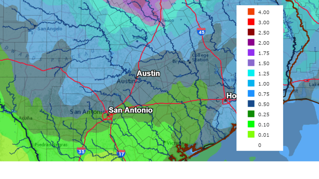
Rain amounts between Monday and Thursday are forecast to generally total between 0.5 and 1 inch across the Hill Country and Central Texas regions while totaling less than a half inch across the coastal plains region.
NWS Rainfall Forecast for the Period 7 am Friday through 7 am Next Friday:
Much cooler temperatures will be in place next week due to the cold front, the overcast sky and occasional rain.
- High temperatures Monday will include the mid and upper 50s across the Hill Country, the mid and upper 60s across Central Texas with lower 80s across the coastal plains.
- Lows Tuesday morning are forecast to reach the upper 30s to low 40s across the Hill Country, the mid and upper 40s across Central Texas and the mid to upper 50s near the coast.
- High temperatures Tuesday will be near 50-55 degrees across the Hill Country and Central Texas regions and near 68-72 degrees towards the coast.
- Lows Wednesday morning are forecast to be in the low 40s across the Hill Country, the mid and upper 40s across Central Texas and the mid to upper 50s near the coast.
- High temperatures Wednesday will be in the low and mid-60s across the Hill Country and Central Texas regions and in the low 70s towards the coast.
- Lows Thursday morning will be in the upper 40s across the Hill Country, the low to mid-50s across Central Texas and the upper 50s towards the coast.
- High temperatures Thursday will be in the low 70s.
Clouds will clear next Thursday afternoon followed by sunny and dry conditions next Friday into next weekend. High temperatures will be around 78-80 degrees, with low temperatures in the 50s.
Long-range forecasts for the week of November 2nd call for continued sunny and dry weather. High temperatures look to stay around 80 degrees with low temperatures mostly in the 50s to low 60s.
Tropical Weather Outlook
National Hurricane Center forecasters are closely monitoring broad area of low pressure in the Caribbean Sea, located near Grand Cayman Island. This system is producing a large area of showers and thunderstorms mainly east and south of the center. This system has become much better organized since yesterday, and a tropical depression could form during the next couple of days while the low moves slowly off toward the northwest. This system is anticipated to move near western Cuba this weekend and move slowly across the southeastern Gulf of Mexico by early next week. NHC forecasters are giving this system a 60 percent chance for development over the next 5 days.
This system poses no threat to the western Gulf of Mexico and the Texas coast.
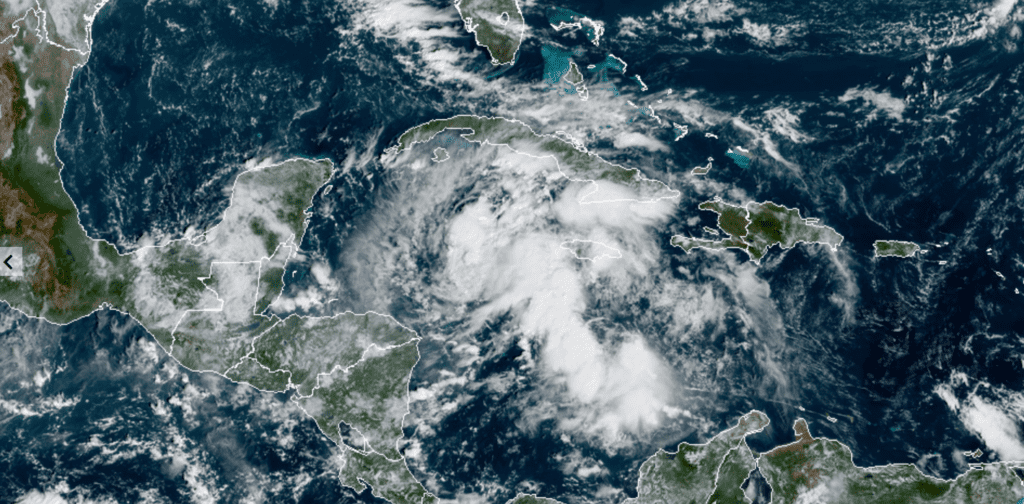
RAMMB-CIRA/Colorado State University 10/23/2020 8:50 am CDT
Hurricane Epsilon continues to move over the Atlantic Ocean, to the north of Bermuda. As of 10 am CDT, the center of Hurricane Epsilon was located about 225 miles northeast of Bermuda and moving to the north near 10 mph. A general northward motion with increasing forward speed is expected through early Saturday, with a very fast forward motion toward the northeast early next week.
Maximum sustained winds remain near 85 mph with higher gusts. Some fluctuations in strength could occur for the next day or so before gradual weakening begins on Sunday. Epsilon could lose tropical characteristics late Sunday.
Have a good weekend.
Bob
Social Media