Our region’s recent brush with wintery precipitation has come to an end. While sleet pellets and light freezing rain were observed at several locations across the region, very dry air in the lower atmosphere precluded much of the precipitation from reaching the surface. As a result, travel impacts were minimal. The last of the precipitation exited the region and moved out over the Gulf of Mexico before sunrise Friday morning.
Sunny and dry weather will be in place this afternoon as a ridge of high pressure spreads over Texas out of Mexico. An area of clouds over the coastal region this morning will push offshore early this afternoon. Despite the sunshine, today’s temperatures will remain cold, with readings topping out only in the mid and upper 40s. Wind speeds will be considerably lighter than the past couple of days, generally ranging between 5 and 10 mph.
Very cold temperatures are forecast Friday night into Saturday morning. The combination of a clear sky and light winds will allow readings to fall steadily after sunset. A freeze is expected across the entire region.
- Lows Saturday morning will include the upper teens to low 20s across the Hill Country, the low and mid-20s across Central Texas and the upper 20s to 30 degrees across the coastal plains region.
A gradual warmup is forecast this weekend as the arctic air mass slowly pushes off to the east. The sky will be sunny Saturday. On Sunday, clouds are forecast to increase in advance of a trough of low pressure tracking into northern Mexico out of the Desert Southwest.
- High temperatures Saturday are forecast to be in the low 50s.
- Lows Sunday morning will range from about 30 degrees across the Hill Country, to the low and mid-30s across Central Texas, to the mid-30s near the coast.
- High temperatures Sunday will generally be in the upper 50s.
- Lows Monday morning will range from the upper 30s across the Hill Country, to the low and mid-40s at most other locations.
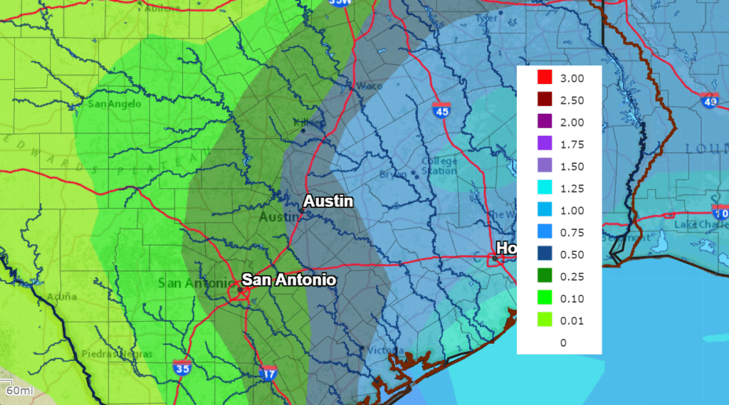
The trough of low pressure over northern Mexico is forecast to track to the east, moving across Central and North Texas Monday into Monday night. The trough is predicted to pull significant moisture north from the Gulf of Mexico beginning Sunday night. With the atmosphere moistening up, there will be a 40 percent chance for rain showers developing after midnight Sunday night. On Monday, widespread rain showers are forecast across the region as the trough moves overhead. Scattered thunderstorms will possible across the coastal plains region. The rain is predicted to end from west to east late Monday afternoon into Monday evening.
Rain amounts Sunday night through Monday evening will be highest across the coastal plains, and lowest across the Hill Country. Totals are forecast to average less than a quarter inch across the western Hill Country and between 0.25 and 0.5 inches across the eastern Hill Country. Across Central Texas, totals are predicted to average between 0.5 and 0.75 inches while coastal totals will average near 1-1.25 inches.
NWS Rainfall Forecast for the Period 6 pm Friday through 6 pm Thursday:
High temperatures Monday are forecast to be in the mid and upper 50s. Lows Tuesday morning will be in the low 40s.
Mostly sunny weather is forecast Tuesday. Expect a high temperature around 58-60 degrees. A strong, Canadian cold front is predicted to push south through our area sometime Tuesday afternoon into Tuesday evening, bringing another blast of cold air. However, the magnitude of this next cold push doesn’t look quite as cold as the arctic air we’ve seen this week. No rain is expected with front. Sunny, breezy and cooler weather will follow next Wednesday and Thursday.
- High temperatures Tuesday will be around 60 degrees.
- Lows Wednesday and Thursday mornings will include the upper 20s Hill Country, the low and mid-30s Central Texas, and in the upper 30s towards the coast.
- High temperatures Wednesday and Thursday are forecast to be in the low 50s.
The outlook for next Friday into next weekend calls for sunny, dry and slightly warmer weather. Expect high temperatures in the low 60s, with lows in the 40s. Taking a peek into the first week of February, mild temperatures look to continue, with highs in the 60s and lows in the 40s.
Catch a Great View of Orion
Tonight look for the constellation Orion the Hunter. It’s a constant companion on winter evenings in the Northern Hemisphere. It’s probably the easiest constellation to spot thanks to its distinctive Belt. Orion’s Belt consists of three medium-bright stars in a short, straight row at the Hunter’s waistline. If you see any three equally bright stars in a row this evening, you’re probably looking at Orion. Orion is now high in the southeastern sky right after dark, standing highest due south around 9 pm.
Below Orion, look for the star Sirius, twinkling brightly after dinnertime. Sirius is the brightest star in the night sky.
Have a good weekend.
Bob
Social Media