Quiet, fall weather continues across Central and South Texas in the wake of Sunday’s weak cold front. The reinforcing push of cool, dry air allowed temperatures to fall into the 40s and 30s across the region earlier this morning. According to LCRA’s Hydromet, the lowest gauged temperature was 28 degrees, recorded in northwestern Kimble County, about 17 miles to the northwest of Junction. Several Hill Country sites showed low temperatures near 30-32 degrees.
Monday’s weather maps show yesterday’s cold front has reached the eastern Gulf of Mexico. A large dome of Canadian high pressure now covers Texas and the southern U.S., promoting cool, dry and sunny weather. The high pressure system is forecast to begin moving off to the east Tuesday, promoting the return of southerly breezes for Tuesday and the remainder of the week. These breezes will bring slowly warming temperatures and somewhat higher humidity levels late week. A broad ridge of high pressure in the upper atmosphere in place over Texas will keep this week’s weather sunny and dry.
High temperatures will be around 72-75 degrees this afternoon, warming to the mid and upper 70s Tuesday and to around 78-80 degrees Wednesday through Friday.
Low temperatures Tuesday morning will generally be in the low and mid-40s while lows Wednesday morning will be in the mid and upper 40s. Lows Thursday, Friday and Saturday mornings will be in the mid and upper 50s.
Long-range forecasts continue to call for changes in our weather pattern this weekend into early next week when a large trough of low pressure pushes inland along the West Coast and slowly lifts up to the northeast. In advance of the trough, warm and moist Gulf air is forecast to spread into Texas. Our region will see a pattern of morning clouds and afternoon sunshine Saturday and Sunday. A few spotty rain showers will be possible across the coastal plains region by Sunday. High temperatures both days will be near 80-82 degrees while low temperatures will be in the 60s.
A cold front associated with the upper trough is predicted to track across Texas late Monday into Tuesday. Forecasts call for an area of rain showers and scattered thunderstorms to develop ahead of and along the cold front, with the rain tapering off Tuesday night into Wednesday morning. Sunny and dry weather is forecast the latter half of next week. Although there is considerable uncertainty into just how much rain will develop across our region, ensemble solutions call for totals to average around a half inch.
High temperatures next Monday will still be in the low 80s but cooler air will arrive Tuesday and continue for the reminder of the week. High temperatures will be around 70-72 degrees while low temperatures will generally be in the 50s.
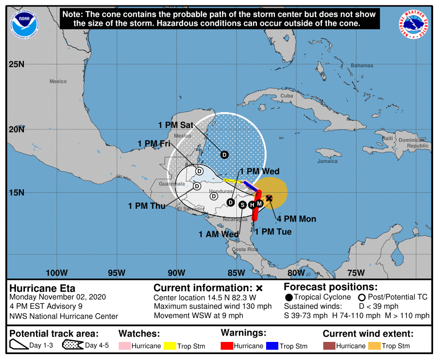
Tropical Weather Outlook
…Hurricane Eta becomes a Category 4 Hurricane…
As of 4:00 pm CST, the center of Hurricane Eta was located over the southwestern Caribbean Sea, or about 70 miles east-southeast of Cabo Gracias a Dios, on the Nicaragua/Honduras border. Eta is moving toward the west-southwest near 9 mph (15 km/h), and this general motion is expected to continue through early Tuesday. A slower westward or west-northwestward motion is forecast to begin on Tuesday and continue through Thursday. On the forecast track, the center of Eta is expected to make landfall along the coast of Nicaragua Monday night or early Tuesday. The center of Eta is forecast to move farther inland over northern Nicaragua through Wednesday night, and then move across central portions of Honduras on Thursday.
Maximum sustained winds have increased to near 130 mph with higher gusts. Eta is a category 4 hurricane on the Saffir-Simpson Hurricane Wind Scale. Additional strengthening is forecast until Eta reaches the coast of Nicaragua. Weakening will begin after the system moves inland.

RAMMB-CIRA Colorado State University 11/02/2020 2:10 pm CST
After landfall, a weakening Eta is expected to continue moving to the west at a slow rate of speed and into the higher terrain over inland central America. By the end of this week, a weakness will begin to develop over the eastern Gulf of Mexico and FL and the remains of Eta may get pulled northward into the far western Caribbean Sea. While forecast models continue to show some sort of tropical system lifting northward over the western Caribbean Sea late this week, it is unclear if this modeled forecasted system is Eta or a new tropical system that forms. Given the amount of time Eta is expected to spend over the mountains of central America, it is unclear if much will be left of the low level circulation to enter the far southwestern/western Caribbean Sea.
October Climate Summary
Despite several spells of cool weather, October temperatures averaged between 1 and 2 degrees above normal across the majority of the Hill Country, Central Texas and the middle Texas coast. Rainfall was well below normal across the entire region, with most totals averaging less than a half inch. As a result, rainfall averaged 3-4 inches below normal.
In Austin, Camp Mabry’s October temperature averaged 71.8 degrees, which was 0.6 degrees above normal. October 2020 ranks as the 32nd warmest October on record. Rainfall totaled 0.35 inches, which was 3.52 inches below normal. October 2020 ranks as the 14th driest October on record.
Austin-Bergstrom’s October temperature averaged 69.6 degrees, which was 0.6 degrees above normal. October 2020 ranks as the 28th coolest on record. Rainfall totaled 0.34 inches, which was 3.90 inches below normal. October 2020 ranks as the 6th driest October on record.
Have a good week.
Bob
Social Media