Few changes in the current hot, summer pattern are expected as we head into the weekend. This week’s weather pattern has been dominated by a strong area of high pressure in the upper atmosphere ridging into Texas out of the western U.S. While forecasts call for the ridge to flatten and weaken slightly over the next few days, the ridge is still expected to cause more sunny and very hot weather through Monday. Some changes in the pattern do look to take place beginning late Monday, continuing through the middle of next week when the ridge weakens enough to allow a weak cold front to sag south into Texas. The front is expected bring our region a chance for rain showers and thunderstorms along with two to three days of less hot temperatures. Potential Tropical Cyclone Three is forecast to make landfall somewhere along the eastern Gulf coast of Louisiana late tonight or early Saturday morning, having little to no impact on weather conditions across the middle Texas coast or Central Texas.
This afternoon through Sunday afternoon, weather conditions will continue mostly sunny and quite hot across the region. An isolated thunderstorm or two cannot be ruled out across Central Texas this afternoon and again Saturday afternoon, but the chance for rain at any given location will be less than 20 percent. There will be a 20 percent chance for a few scattered rain showers and thunderstorms across the middle Texas coast Saturday and Sunday afternoons as an area of tropical moisture spreads inland behind the tropical system. Rain amounts, if any, are predicted to total less than a quarter inch.
- High temperatures this afternoon and Saturday are forecast to be in the mid and upper 90s across the Hill Country and Central Texas regions, with low and mid-90s across the coastal plains.
- High temperatures on Father’s Day are forecast to be near 98-100 degrees across the Hill Country and Central Texas regions and in the mid-90s across the coastal plains.
Mostly sunny, dry and very hot weather is forecast to continue Monday. High temperatures are forecast to be near 98-101 degrees across the Hill Country and Central Texas regions, with middle 90s expected across the coastal plains.
An unusual, late season cold front is forecast to sag south out of the Plains states and into North Texas Monday night. Forecasts call for the front to reach the Austin/Central Texas region Tuesday morning where it will pull up stationary. With a very moist atmosphere in place, the front will bring a chance for showers and thunderstorms. Rainfall is not expected to be all that heavy. Severe thunderstorms are not expected, but a couple of strong storms will be possible Monday night through Tuesday.
Forecasts call for a 40-50 percent chance for scattered rain showers and thunderstorms developing across the Hill Country and Central Texas regions Monday night, followed by a 40-50 percent chance for additional showers and storms across the entire region on Tuesday. Just a slight chance for scattered rain showers and thunderstorms is forecast Tuesday night through Wednesday. Rainfall between Monday night and Wednesday night is forecast to generally average around a half inch, with a few isolated totals to near 1 inch possible.
- A short break from the very hot temperatures is forecast Tuesday and Wednesday, with high temperatures Tuesday near 90 degrees, and in the low 90s Wednesday.
Thursday into the following weekend, familiar summertime weather will resume as the unusual cold front lifts back to the north and the ridge to our west nudges a bit to the east. Expect high temperatures back into the mid and upper 90s across the Hill Country and Central Texas regions, with low to mid-90s expected towards the coast.
Looking out into the week of June 28th, some forecasts are indicating another unusual June cold front will sink south into Texas, possibly bringing our region a few showers.
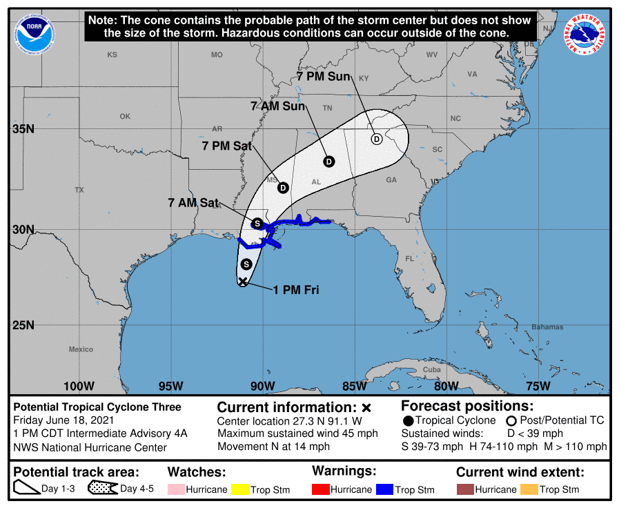
Potential Tropical Cyclone Three
Forecasters continue to closely monitor a strong tropical disturbance in the Gulf of Mexico that is attempting to develop into a tropical depression or tropical storm. Friday’s satellite images showed the disturbance was gradually becoming better organized. Air Force Hurricane Hunters have been investigating the system and they found a surface center a little to the east of where it was previously expected it to be, but have otherwise reported generally light winds.
As of 1:00 pm CDT Friday, the tropical disturbance was centered over the west-central Gulf of Mexico, roughly 165 miles south of Morgan City, Louisiana. The system was moving toward the north near 14 mph, and a north to north-northeast motion is expected during the next day or so. On the forecast track, the system will make landfall along the north-central Gulf Coast tonight or early Saturday. A northeastward motion across the southeastern United States is likely after landfall through the weekend.
Satellite data indicate that maximum sustained winds have increased to near 45 mph with higher gusts. The circulation is gradually becoming better defined, and a tropical storm is likely to form over the north-central Gulf of Mexico later on Friday or Friday night.
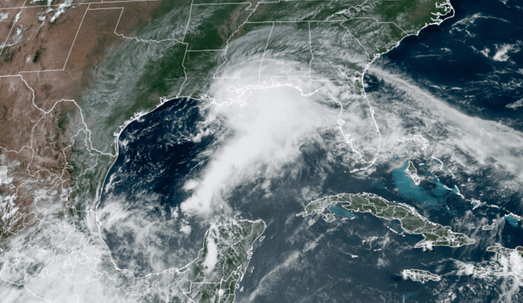
Colorado State University/RAMMB 06/18/2021 2:10 pm CDT
Summer Officially Begins Sunday Night
The summer solstice will occur precisely Sunday night June 20 , at 10:32 pm CDT. For us in the Northern Hemisphere, this solstice will mark the beginning of summer and the longest day of the year. Early dawns. Long days. Late sunsets. Short nights. Meanwhile, south of the equator, winter will begin.
The solstice is also the day when the midday Sun passes the closest it ever can to being straight overhead, and thus when your shadow becomes the shortest it can ever be at your location. And if you have a good west-northwest horizon, mark carefully where the Sun sets. In a few days you should be able to detect that the Sun is again starting to set a just little south (left) of that point.
In Austin, the sun will rise Monday at 6:29 am and set at 8:35pm, making daylength 14 hours and 6 minutes. The midday sun will reach a peak altitude in the sky of 83 degrees.
Have a good weekend.
Bob
Social Media