Thursday’s weather featured some of the windiest conditions our region has seen quite some time. For much of the afternoon, most areas across the Hill Country, Central Texas and the middle Texas coast saw sustained winds of at least 20 mph. Peak wind gusts were generally in the range 40-45 mph. According to the National Weather Service, the highest observed wind gust across Central Texas was 52 mph at the Burnet Municipal Airport. Austin-Bergstrom International Airport recorded a peak gust of 48 mph. Across Texas, Dallas-Fort Worth International Airport and Forth Meacham Field both recorded a peak gust of 60 mph while Houston’s Hobby Airport recorded a peak gust of 61 mph!
Thursday’s unusually strong winds were caused by a strong area of low pressure located over northern Arkansas. A strong north-to-south low-level jet of air developed on the west side of the low Thursday morning. With warming temperatures in the afternoon, mixing of the lower atmosphere allowed these strong winds to spread down to surface. Fortunately, wind speeds decreased overnight as temperatures cooled into the 50s and 40s.
Sunny and windy weather is forecast again this afternoon, but wind speeds shouldn’t be quite as high as what we saw on Thursday. Friday’s weather maps showed the intense low pressure area has moved from northern Arkansas to western Kentucky, and the low-level jet has shifted east toward the Texas/Louisiana border. Winds across the region through late afternoon are forecast to be in the range of 15-25 mph. Some occasional gusts up to 35 mph can be expected. Afternoon temperatures are predicted to warm into the low and middle 70s. Wind speeds are forecast to decrease beginning around sunset. Expect northwesterly winds to settle down to around 5-10 mph this evening and overnight. However, some occasional gusts to 25 can be expected up till midnight.
Take note: elevated to near critical fire weather conditions will be in place this afternoon due to the combination of the strong winds and very low relative humidity levels.
Sunny, pleasant, fall-like weather is forecast this weekend and early next week as the intense area of low pressure moves off to the northeast. Light winds are predicted for Saturday and Sunday. A stable ridge of high pressure in the middle and upper atmosphere will cause dry and stable atmospheric conditions. Daytime temperatures will be mild while nighttime readings will be cool.
- Lows Saturday morning will include the upper 30s to low 40s across the Hill Country, the low and mid-40s across Central Texas and the mid-40s across the coastal plains.
- Lows Sunday morning will generally range from 45 to 50 degrees.
- Lows Monday morning will generally be around 50-52 degrees.
- High temperatures Saturday, Sunday and Monday are forecast to be near 78-80 degrees.
For the “Trick or Treaters” Sunday evening, expect temperatures to be in the 70s in the early evening, with readings falling into the 60s by 9 or 10 pm.
Tuesday’s weather will likely feature a sunny sky with a slow increase in clouds. Lows Tuesday morning will range from the low 50s west, to the upper 50s towards the coast. High temperatures will be close to 80 degrees.
A cloudy, somewhat unsettled and cooler weather pattern is predicted for the second half of next week. Forecasts call for a strong, Canadian cold front to sink south across the area late Wednesday late afternoon into Wednesday evening. Ahead of the front, clouds and moisture will increase Wednesday morning, followed by a 30-40 percent chance for scattered rain showers and thunderstorms Wednesday afternoon and Wednesday night. Temperatures Wednesday night are forecast to fall into the mid and upper 40s across the Hill Country and Central Texas.
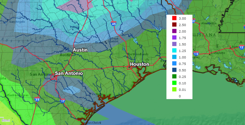
Cloudy and cool conditions are forecast Thursday through Friday. Periods of light to moderate rain can be expected both days as a series of low pressure troughs move over the area from the west. The chance for rain is forecast to diminish late Friday into Saturday morning. Total rain amounts through the periods are forecast to generally average between a half inch and 1 inch.
NWS Rainfall Forecast for the Period 7 pm Friday through 7 pm Next Friday:
Temperatures will be on the cool side next Thursday and Friday, with highs in the low and mid-60s. Lows will be in the 40s.
Looking out to next weekend, sunny and cool weather is forecast. Highs will be in the 60s to near 70 degrees with low temperatures close to 50 degrees.
The outlook for the week of November 8th calls for high temperatures to be in the 70s, with lows staying in the 50s.
Tropical Weather Outlook
Weather conditions are quiet across the Gulf of Mexico and Caribbean Sea. There are no systems in place which pose a threat for tropical development over the next 5 days.
National Hurricane Center forecasters are monitoring a large are of showers and thunderstorms located several hundred miles south of Cape Race, Newfoundland that are associated with a strong frontal low pressure area. The non-tropical low is forecast to move east-southeastward and southeastward toward slightly warmer waters during the next few days, and it could lose its associated fronts and acquire some subtropical characteristics this weekend or early next week while over the central Atlantic. NHC forecasters are giving this system a 30 percent chance for tropical or subtropical development over the next 5 days.
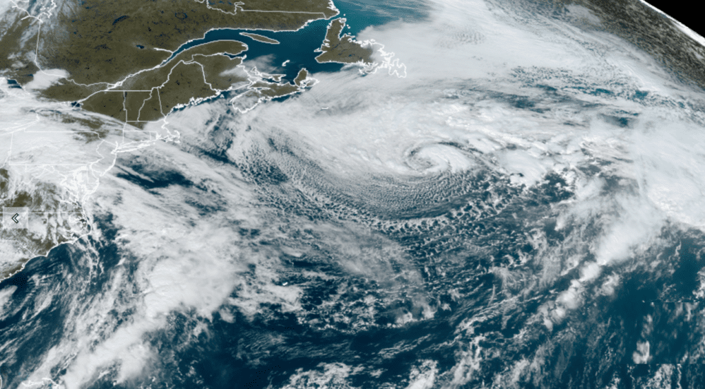
NOAA/Colorado State University/RAMMB 10/29/21 12:00 pm CDT
Catch a Stunning View of Venus, Jupiter and Saturn
Venus is currently shining at a brilliant magnitude –4.6, in the southwest during and after twilight. Venus now stays up for nearly an hour after dark. It will continue to get a little higher and brighter into early December. Venus reaches its greatest elongation – its farthest point from the sunset – on October 29th.
Jupiter and Saturn continue to shine in the south during evening, 15° apart in the constellation Capricornus. Jupiter is the bright one at magnitude –2.5. Saturn, to its right or lower right, is fainter at mag +0.6. In twilight they’re just beginning to tilt. As evening advances they tilt more steeply as they move westward. Saturn sets around 11 or midnight daylight-saving time, Jupiter about an hour later.
This Will be the Last Week of Daylight Saving Time
Just a heads up: the seasonal time change to Standard Time will occur next Sunday, Nov. 7th. At that time, we will set our clocks back one hour, gaining an hour of daylight in the mornings
Have a great weekend and Happy Halloween!
Bob
Social Media