A quiet, late summer weather pattern continues across Central and South Texas. The biggest change in the weather to have taken place recently was the passage of a weak, Canadian cold front Sunday afternoon. The front shifted winds out of the northeast and brought in noticeably drier air. The combination of a clear sky and drier air allowed temperatures early Monday morning to fall into the 60s across the Hill Country and most of Central Texas. According to LCRA’s Hydromet, minimum temperatures included the low and mid-60s across the Hill Country, mid and upper 60s across most of Central Texas, and low to mid-70s for areas south of Interstate 10.
The weather looks to stay sunny, warm, and dry throughout the week as a stable ridge of high pressure in the upper atmosphere spreads over Texas out of the Desert Southwest and northern Mexico. The drier air currently in place is predicted to remain over the area through Wednesday, before humid Gulf air makes a return late week and through the upcoming weekend. Daytime temperatures will still be quite warm.
- High temperatures Monday will be near 88-90 degrees across the Hill Country, and in the low 90s across Central Texas and the coastal plains.
- High temperatures Tuesday through Friday are forecast to be in the mid-90s across Central Texas, and in the low 90s across the Hill Country and coastal regions.
- Lows Tuesday, Wednesday, and Thursday mornings are forecast to be in the mid and upper 60s across the Hill Country and Central Texas regions, and near 68-70 degrees across the coastal plains.
- Lows Friday morning are predicted to be near 68-70 degrees.
Do note increasing moisture Thursday into Friday will bring a very slight chance for a few isolated afternoon rain showers to parts of Central Texas. AT the same time, there will be 30-40 percent chance for scattered rain showers and isolated thunderstorms across the coastal region. Rain amounts, if any are forecast to average less than a tenth of an inch across Central Texas, and be below a quarter inch across the coastal plains.
Few changes are expected over the upcoming weekend. Weather conditions will remain mostly sunny and warm. There will be a 30 percent chance for scattered rain showers across the coastal region, while other areas look to stay dry. High temperatures are forecast to be in the mid to upper 90s across the Hill Country and Central Texas regions, and in the low 90s coastal area. Low temperatures will generally be in the low 70s.
The outlook for next week calls for little change. A sunny, dry, and warm late summer pattern will continue as a weak ridge of high pressure remains across Texas. Expect high temperatures generally in the low and mid-90s, with lows in the low to mid-70s.
Unfortunately, this late summer pattern is not showing any signs of backing down anytime soon.
Tropical Weather Update
In the wake of hurricanes Danielle and Earl last week, conditions have now trended fairly quiet across the tropical Atlantic.
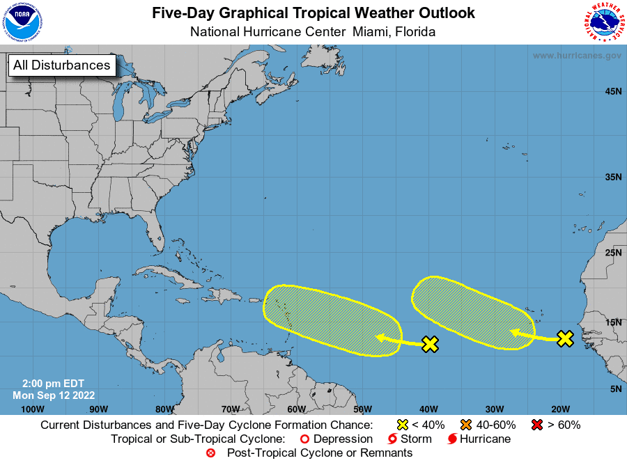
National Hurricane Center forecasters are monitoring a tropical wave located midway between the west coast of Africa and the Windward Islands, and a second tropical wave situated just off the west coast of Africa. Both systems are located in environments that are just marginally conducive for tropical development. NHC forecasters are giving both systems a low chance, just a 20 percent chance, for tropical development over the next 5 days.
Weather conditions are currently quiet across the Gulf of Mexico and the Caribbean Sea. There are no systems in place which pose a threat for tropical development over the next 5 days.
Watch for the International Space Station this Week
The International Space Station will be returning to the evening sky this week, with passes visible each night through Friday. The transit Wednesday evening will be especially good, with the ISS quite bright and passing nearly overhead around 8:30 pm.
To find our more specific for your particular area, visit NASA’s Spot the Station website: https://spotthestation.nasa.gov
Bob
Social Media