After a week of cloudy, cold and damp weather, it’s nice to finally see the sun again. The recent cold pattern is finally beginning to move out, but not before bringing our region another freeze earlier this morning. Freezing temperatures were observed early Monday across the Hill Country and Central Texas regions, and even into parts of the coastal plains. According to LCRA’s Hydromet, spots across the northern and western Hill Country saw readings dip into the upper teens. Across the rest of the region, low temperatures were generally in the 20s, with 30s noted across the coastal plains. In Austin, the low temperature at Austin-Bergstrom Airport was a record-setting 21 degrees. At Austin-Camp Mabry, the low temperature was 33 degrees. Monday’s very chilly temperatures may very well be the last of the really cold readings for this winter as a milder and more spring-like weather pattern is forecast to take shape over the next couple of weeks.
Dry, quiet and very stable atmospheric conditions are in place as we start off the week. A ridge of high pressure located over northern Mexico and the Desert Southwest is forecast to spread over Texas Tuesday through Friday, keeping the weather pattern dry and stable.
This afternoon through Tuesday, scattered high-level clouds are predicted to spread over Texas out of the eastern Pacific. They should have little to no impact on our region’s weather. Light south and southwesterly breezes will return Monday night and continue through Tuesday. A light freeze is forecast for much of the Hill Country early Tuesday, while readings stay just above freezing across the rest of the region.
- High temperatures Monday will be in the mid-60s.
- Low temperatures Tuesday will include the low 30s across the Hill Country, the mid-30s across Central Texas and the upper 30s across the coastal plains.
- High temperatures Tuesday are forecast to be near 68-70 degrees.
- Low temperatures Wednesday morning will generally be in the upper 30s to low 40s.
For Wednesday and Thursday, expect mostly sunny conditions and even warmer temperatures:
- High temperatures Wednesday are forecast to reach the low and mid-70s.
- Low temperatures Thursday morning will be in the low and mid-40s.
- High temperatures Thursday are predicted to be in the mid and upper 70s.
- Low temperatures Friday morning will generally be in the low 50s.
Friday through Saturday, expect a mostly cloudy to partly cloudy sky and even warmer temperatures as moisture begins returning off the Gulf of Mexico ahead of a trough of low pressure located over the Desert Southwest. No rain is forecast, but relative humidity levels will be noticeably higher.
- High temperatures Friday are forecast to be in the mid and upper 70s.
- Lows Saturday morning are predicted to be near 60-62 degrees.
- High temperatures Saturday are forecast to be near 80-82 degrees.
- Lows Sunday morning are predicted to be close to 60 degrees.
Forecasts call for a slight chance for scattered rain showers and isolated thunderstorms across the region next Sunday into midday Monday as the western trough lifts to the northeast and helps push the dry line and a Pacific cold front across Texas. The most favorable area for rain is predicted to be across North and Northeast Texas, closer to the position of the upper trough. Just a slight chance for rain and thunderstorms is expected across the Hill Country, Central Texas, and the middle Texas coast. Rain amounts should total well below a quarter inch.
- High temperatures Sunday and Monday are forecast to be in the mid and upper 70s.
- Low temperatures next Monday are predicted to be in the low 50s.
The outlook for the rest of next week calls for mostly sunny weather Tuesday through Thursday. High temperatures are predicted to be near 68-70 degrees, with low temperatures around 50 degrees. Forecasts call for a chance for rain to develop late next week as another Pacific trough of low pressure tracks east out of the Southwestern U.S.
February Has Been an Unusually Cold Month
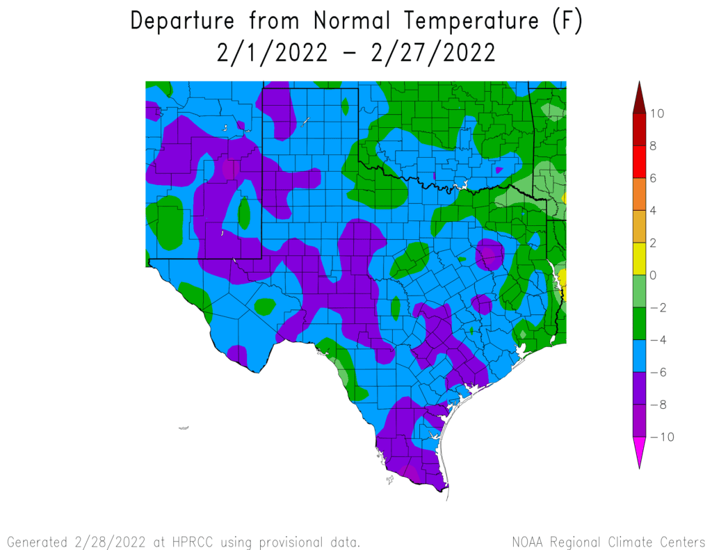
If you thought we had more cold weather than normal in February, you are correct. Data through February 27th shows temperatures this month have generally averaged between 4 and 8 degrees below normal across the majority of Texas. This will likely rank February 2022 among some of the coldest Februarys on record. In Austin, the temperature at Austin-Bergstrom Airport has averaged 47.0 degrees, which is 7.2 degrees below normal. This will likely end up being be the 3rd coldest February on record at Austin-Bergstrom. At Austin-Camp Mabry, the temperature has averaged 49.9 degrees, which is 6.1 degrees below normal. Here, February 2022 will likely rank as the 23rd coldest February on record.
Bob
Social Media