This has been quite a week for extreme heat, with most areas seeing several days with triple digit temperatures. For example, Austin-Camp Mabry has now seen 8 consecutive days with the temperature at or above 100 degrees. The hottest of these days had a sizzling temperature of 108 degrees! After a such a miserably hot and dry week, a few changes in the weather pattern are finally on the horizon. The powerful high pressure ridge which was centered earlier this week near El Paso has shifted to the northeast. Friday morning’s analysis showed the ridge is now centered over western Arkansas. With the ridge centered northeast of our region, a clockwise wind flow around the ridge is causing an easterly flow of wind from the Gulf of Mexico into the southern half of Texas. Meteorologists refer to this flow as the “tropical easterlies” as they will often bring clouds, and moisture from the tropics inland into Texas.
Friday morning, a weak trough of low pressure embedded within this easterly flow was pushing inland along the middle and upper Texas coast, spreading tropical moisture inland. Radar showed an a fairly large area of scattered rain showers and thunderstorms occurring between Victoria, Wharton, Houston and Beaumont. The area of showers is forecast to continue spreading inland this afternoon to near or just north of the Interstate 10 corridor. Here, the probability for rain will be near 80 percent this afternoon. Rain amounts are forecast to average around a half inch, with isolated totals to around 1.5 inches possible. Further inland, a few widely scattered rain showers will be possible in the area between La Grange and Austin , but the probability for rain here will only be near, or less than 20 percent.
For the Hill Country and the majority of Central Texas, this afternoon’s weather will be mostly sunny and continued hot, with high temperatures near 100 degrees. High temperatures across the coastal plains will be in the upper 80s to low 90s. This afternoon’s rain shower activity is predicted to diminish in the late afternoon and evening followed by dry and quiet weather overnight.
This weekend, mostly sunny and hot weather is forecast across the region. Friday’s trough of low pressure is forecast to track to the southwest and move into Mexico. A persistent moist flow off the Gulf of Mexico will cause a slight (20 percent) chance for scattered rain showers across the coastal plains region both days. Rain amounts will generally average less than a quarter inch. Dry weather will continue across the Hill Country and Central Texas regions. High temperatures are predicted to trend down slightly as influence from the high pressure ridge diminishes a bit. High temperatures across the Hill Country and Central Texas regions are predicted to be in the upper 90s, with low and mid-90s expected toward the coast.
For the first half of next week, few changes are expected. Mostly sunny and dry weather will continue across the Hill Country and Central Texas regions while isolated to scattered rain showers will be continue across the coastal plains. High temperatures will be in the upper 90s inland, with low to mid-90s expected towards the coast.
Forecasts call for a second and slightly stronger wave of low pressure to push inland along the Texas coast late Wednesday into Thursday. This next system is forecast to pull tropical moisture further inland than what we are seeing from the today’s first system. Scattered rain showers and isolated thunderstorms are forecast to develop across the coastal plains and Central Texas regions and even into parts of the Hill Country late week into next weekend. Rain amounts are not expected to be very heavy, with most totals staying below a half inch. Higher totals are forecast to towards the coast. High temperatures late week and next weekend are predicted to fall to the mid-90s.
Longer-range outlooks call for the period of showers to come to an end as we move into the last week of July. Forecast solutions call for the center of the high pressure ridge to shift from the middle Mississippi Valley region southwest to southern Oklahoma and northwestern Texas, shutting down the tropical easterlies. Sunny, dry and hot weather looks to return, along with more triple-digit temperatures.
Tropical Weather Outlook
Weather conditions are quiet across the tropical Atlantic, the Caribbean Sea and the Gulf of Mexico. There are no systems in place which pose a threat for tropical cyclone development over the next 5 days.
Viewing Comet NEOWISE at Dusk
This will be a great weekend to try to catch a view of comet NEOWISE. The comet is currently visible to the unaided eye, low in the northwestern sky in late twilight. Plan to start looking about 30-45 minutes after sunset. The comet has been fading a little less rapidly than predicted; it is still hanging on at about 2nd magnitude as of July 16th.
To find it, start by spotting the Big Dipper located high in the northwest in late twilight as the stars come out. The Dipper is hanging down by its handle.
From July 17 through 21, the comet is located below the Dipper’s bowl, as shown below, by about 20° to 15°. From July 21 through 2,5 the comet is lower left of the Dipper’s bowl, by roughly 15°. The comet should appear about 10° above the horizon. Holding your fist toward the horizon, the comet’s location will be towards the top of your fist.
You may or may not need binoculars to detect it, depending on how it’s performing, the state of twilight, and the clarity of your sky low in the northwest. Sharan dust, haze and possible clouds may hinder your view. Finding a really dark sky will certainly help.
The comet will be gaining altitude night to night over the next couple of weeks as it gradually fades.
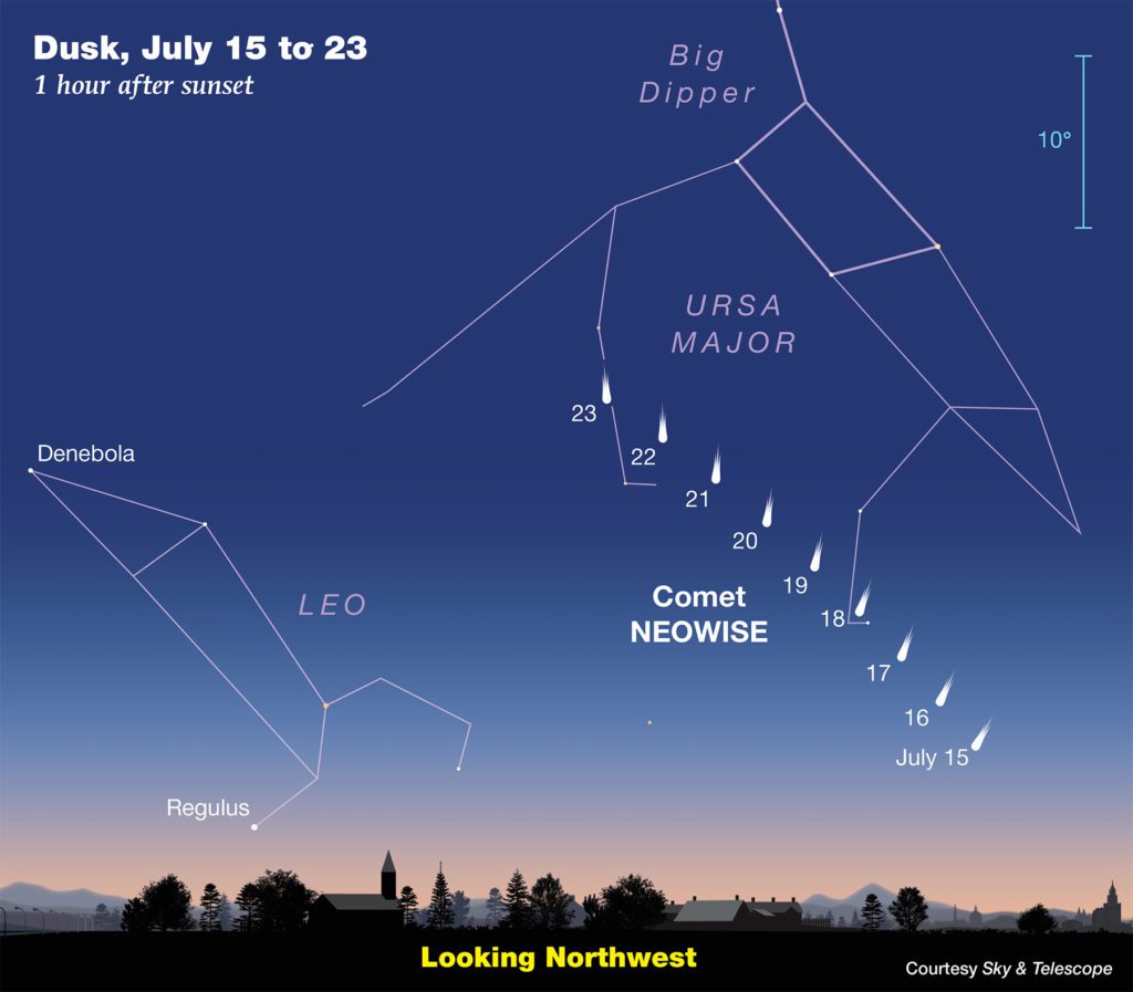
Image Courtesy Sky &Telescope
Have a good weekend.
Bob
Social Media