Pleasant, fall weather conditions are in place across all of Central and South Texas. A weak cold front moved across our region late Thursday, ushering in more cool dry air. This is part of the pattern that has been in place since early in the week when the first strong cold front moved through our area. Friday’s weather maps showed an unusually strong ridge of high pressure along the West Coast, stretching north into western Canada. An unusually deep trough of low pressure stretched from eastern Canada to the southeastern US. Waves of low pressure along the jet stream are sending periodic cold fronts south across the Plains states and into Texas, reinforcing the pleasant, fall-like conditions that are already in place. This type of pattern results in no rain and few clouds as moisture from the Gulf and the Pacific is shunted well off to the south. Forecasts call for this “ridge/trough” type pattern to remain in place through late next week, followed by less amplified ridges and troughs next weekend, continuing into the following week.
Sunny weather is forecast this afternoon, this weekend and all of next week. A reinforcing cold front is predicted to move through the area Sunday, with another front expected on Thursday. No rain is expected with either front.
- High temperatures will be in the low and mid-80s this afternoon, warming to the mid-80s to near 90 degrees Saturday and Sunday. High temperatures next week will generally be in the upper 80s.
- Low temperatures this weekend and next week will range from the mid-50s across the Hill Country to the low and mid-60s across the coastal plains region.
Long-range forecasts for the week of October 12th call for a nearly zonal jet stream pattern across the contiguous U.S. A flow off the Gulf of Mexico is forecast to develop, which should bring a return of somewhat more humid air. There are some indications a few rain showers may develop during the second half of the week, but significant rain is not expected. Little change in the temperature pattern is suggested, with high temperatures staying mostly around 88-90 degrees.
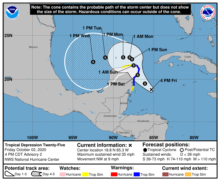
Tropical Depression Twenty-Five
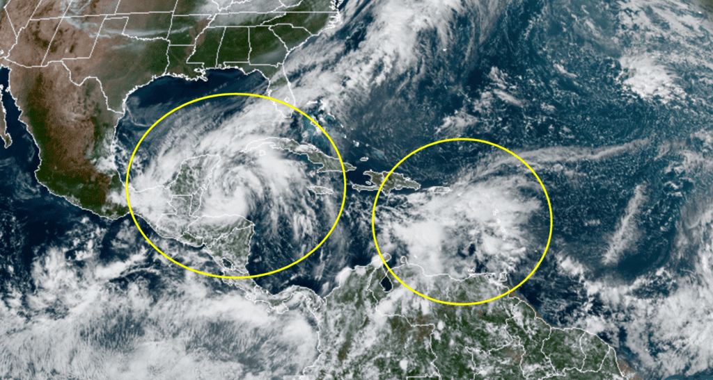
Visible satellite images Friday morning showed cloudiness and showers associated with a persistent area of low pressure area over the northwestern Caribbean Sea became much better organized, compared to Thursday. In addition, low cloud motions suggested a closed circulation had developed and become well defined. Based on these factors, the National Hurricane Center declared the system a tropical depression.
As of 4 pm CDT, the center of Tropical Depression Twenty-Five was located in the western Caribbean Sea, about 155 miles southeast of Cozumel, Mexico. The depression was moving toward the northwest near 9 mph, and a gradual turn toward the north-northwest with a decrease in forward speed is expected over the next couple of days. Maximum sustained winds are near 35 mph, with higher gusts. Some strengthening is forecast, and the depression is expected to become a tropical storm Friday night.
For the next couple of days, the system is forecast to move northwestward to north-northwestward on the southwestern edge of a mid-level high pressure area. This will take the center near or over the northeastern Yucatan Peninsula on Saturday. Beginning Sunday, the steering currents are not so well-defined and there is considerable spread in the track models. However, the National Hurricane Center is calling for the cyclone to move slowly westward over the southern Gulf of Mexico through the first half of next week in response to weak ridging in place over the north-central Gulf of Mexico.
NOAA-RAMMB/CIRA 10/02/20 1:20 pm CDT
The series of cold fronts moving across Texas through late next week is expected to keep the tropical system well to the south of Brownsville. As of now, there appears to be little chance the system will come north to the middle or upper Texas coast.
National Hurricane Center forecasters are also keeping a close eye on the eastern Caribbean Sea, where a tropical wave is producing widespread cloudiness, showers, and thunderstorms. Locally heavy rainfall and gusty winds are currently affecting portions of the ABC Islands, the Lesser Antilles, the Virgin Islands, and Puerto Rico. Environmental conditions are expected to become a little more conducive for development over the next few days, and a tropical depression could form here, while the system moves westward or west-northwestward at about 15 mph across the central and western Caribbean Sea. NHC forecasters are giving this system a 40 percent chance for development over the next 5 days.
MOON-MARS CONJUNCTION
Don’t miss this! Tonight, Oct. 2nd, the Harvest Moon and Mars will be in conjunction, meaning they will be less than 1 degree apart from each other. The Moon will be nearly full, and bright red Mars is only days away from its closest approach to Earth, making the conjunction extra bright and beautiful. The pair will rise in the east just after sunset and stay up all night long. Although they will look like companions, Mars will be 155 times farther away than the Moon. And although Mars looks tiny, it’s twice the Moon’s diameter.
Have a good weekend.
Bob
Social Media