This week’s cold front brought with it some of the coolest air of the season. According to LCRA’s Hydromet, low temperatures Friday morning were generally between 36 and 42 degrees across Central Texas and between 45 and 48 degrees across the coastal plains. The lowest recorded temperature was 34 degrees at a couple of gauges located in northern Travis County, plus another gauge located near Dripping Springs, in Hays County. Across the Hill Country, temperatures stayed a bit warmer overnight thanks to a persistent area of low clouds. Here, lows Friday morning were generally in the upper 40s. In Austin, the temperature reached as low as 42 degrees at Camp Mabry and 38 degrees at Austin-Bergstrom Airport.
Friday morning satellite images showed widespread low clouds persisting across the Hill Country, the Edwards Plateau, and Southwest Texas. These clouds are predicted to slowly thin beginning late morning, with the sky becoming sunny early to mid-afternoon. A sunny sky will be in place across the rest of the region. With abundant sunshine, afternoon high temperatures will range from the low 60s across the Hill Country to the upper 60s towards the coast. Expect a light northeast wind at 5-10 mph. It will be chilly again Friday night. Lows Saturday morning are predicted to be near 40-42 degrees across the Hill Country and Central Texas regions and in the mid-40s across the coastal plains.
Sunny and beautiful weather is forecast over the weekend. A large area of Canadian high pressure will remain over Texas through early Sunday, keeping temperatures very fall-like. The high pressure area is forecast to begin moving off to the east Sunday afternoon and Sunday night, bringing a return of light southeasterly winds.
- High temperatures Saturday are predicted to be in the low 70s, warming to the mid-70s on Sunday.
- Lows Sunday morning are forecast to be in the low and mid-40s, with upper 40s expected towards the coast.
- Lows Monday morning will include the upper 40s across the Hill Country, the upper 40s to low 50s across Central Texas and the low 50s near the coast.
Looking ahead to next week, mostly sunny, dry, and warmer weather is forecast Monday through Wednesday. Southerly winds off the Gulf of Mexico will bring in warmer air and increasing humidity levels. Expect late night and morning clouds followed by mostly sunny conditions in the afternoon.
- High temperatures will be in the upper 70s Monday, warming to near 80 degrees Tuesday and into the low 80s on Wednesday.
- Low temperatures Tuesday through Thursday mornings will generally be in the 50s.
Some slight changes to the weather pattern are forecast to take place Thursday, Veterans Day, when a Pacific cold front pushes southeast across the area. As of now, atmospheric conditions are not shaping up to be all that favorable for rain when the front moves across the Hill Country. The Interstate 35 corridor and areas to the east are predicted to see a slight chance for rain showers—mainly in the afternoon. Rain amounts are forecast to total under a quarter inch. Thursday’s sky will be partly cloudy, with high temperatures in the mid-70s.
Sunny, dry and slightly cooler weather will follow the cold front next Friday. Expect a high temperature near 70 degrees.
A sunny, quiet and fall-like weather pattern is forecast next weekend and most of the week of November 15th as the storm track shifts north and a large ridge of high pressure sets up over the western U.S. High temperatures through the period will generally be in the low 70s, with lows mostly in the upper 40s to low 50s.
Tropical Weather Outlook
Aside from Tropical Storm Wanda over the north Atlantic, weather conditions are quiet across the Gulf of Mexico, the Caribbean Sea and the tropical Atlantic and tropical cyclone formation is not expected for at least the next 5 days.
As of 10 am CDT Friday, the center of Tropical Storm Wanda was located roughly 970 miles west-northwest of the Azores. Wanda was moving toward the south-southeast near 8 mph (13 km/h). A southward motion is expected this afternoon through Saturday, and a turn toward the northeast is expected Saturday night or Sunday. Wanda is forecast to merge with a frontal zone Monday, and become a non-tropical low pressure system by Tuesday. The system is forecast to track north of Ireland the middle of next week. Maximum sustained winds are near 50 mph (with higher gusts. Little change in strength is expected today and tonight, while slight strengthening is possible on Saturday.
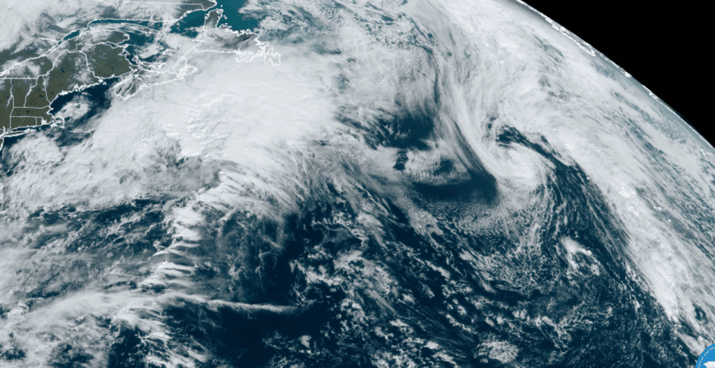
NOAA/Colorado State University/RAMMB 11-05-21 9:50 am CDT
Time Change Weekend
Don’t forget this Sunday morning at 2:00 am, Daylight Saving Time will come to an end. At that time, we will move our clocks back one hour, gaining an extra hour of sleep.
The Moon and Venus
Watch for a young, very thin moon in the western sky over the next few evenings. On Sunday evening, The bright planet Venus and the crescent moon will be very close together as twilight fades.
Have a great weekend!
Bob
Social Media